Welcome to Visit Mickleham, Surrey Places
The Walkfo guide to things to do & explore in Mickleham, Surrey
 Visit Mickleham, Surrey places using Walkfo for free guided tours of the best Mickleham, Surrey places to visit. A unique way to experience Mickleham, Surrey’s places, Walkfo allows you to explore Mickleham, Surrey as you would a museum or art gallery with audio guides.
Visiting Mickleham, Surrey Walkfo Preview
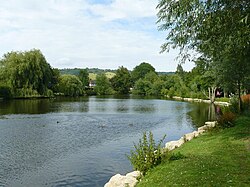
Mickleham is a village between Dorking and Leatherhead in Surrey. The civil parish covers 7.31 square kilometres (1,810 acres) and includes the hamlet of Fredley. The larger ecclesiastical parish includes the majority of the neighbouring village of Westhumble. When you visit Mickleham, Surrey, Walkfo brings Mickleham, Surrey places to life as you travel by foot, bike, bus or car with a mobile phone & headphones.
Mickleham, Surrey Places Overview: History, Culture & Facts about Mickleham, Surrey
Visit Mickleham, Surrey – Walkfo’s stats for the places to visit
With 43 audio plaques & Mickleham, Surrey places for you to explore in the Mickleham, Surrey area, Walkfo is the world’s largest heritage & history digital plaque provider. The AI continually learns & refines facts about the best Mickleham, Surrey places to visit from travel & tourism authorities (like Wikipedia), converting history into an interactive audio experience.
Mickleham, Surrey history
Mickleham appears in the Domesday Book of 1086 as Michelham and Micleham. It was partly held by Nigel from the Bishop of Bayeux and partly by Oswald from (under) Richard de Tonbridge. It rendered £10 per year to its overlords.
Mickleham, Surrey landmarks
The surrounding area contains many Sites of Special Scientific Interest (SSSI) including the Mickleham Downs and panoramic beauty spot of Box Hill. River Mole flows underground due to the chalk bed being dissolved, forming swallow holes (sinkholes)
Why visit Mickleham, Surrey with Walkfo Travel Guide App?
 You can visit Mickleham, Surrey places with Walkfo Mickleham, Surrey to hear history at Mickleham, Surrey’s places whilst walking around using the free digital tour app. Walkfo Mickleham, Surrey has 43 places to visit in our interactive Mickleham, Surrey map, with amazing history, culture & travel facts you can explore the same way you would at a museum or art gallery with information audio headset. With Walkfo, you can travel by foot, bike or bus throughout Mickleham, Surrey, being in the moment, without digital distraction or limits to a specific walking route. Our historic audio walks, National Trust interactive audio experiences, digital tour guides for English Heritage locations are available at Mickleham, Surrey places, with a AI tour guide to help you get the best from a visit to Mickleham, Surrey & the surrounding areas.
“Curated content for millions of locations across the UK, with 43 audio facts unique to Mickleham, Surrey places in an interactive Mickleham, Surrey map you can explore.”
Walkfo: Visit Mickleham, Surrey Places Map
43 tourist, history, culture & geography spots
Mickleham, Surrey historic spots | Mickleham, Surrey tourist destinations | Mickleham, Surrey plaques | Mickleham, Surrey geographic features |
| Walkfo Mickleham, Surrey tourism map key: places to see & visit like National Trust sites, Blue Plaques, English Heritage locations & top tourist destinations in Mickleham, Surrey | |||
Best Mickleham, Surrey places to visit
Mickleham, Surrey has places to explore by foot, bike or bus. Below are a selection of the varied Mickleham, Surrey’s destinations you can visit with additional content available at the Walkfo Mickleham, Surrey’s information audio spots:
 | Epsom & Ewell F.C. Epsom & Ewell Football Club groundshare at Leatherhead’s Fetcham Grove. The club have played outside Epsom since leaving their West Street Ground in 1993. Epsom are currently members of the Southern Combination Division One. |
 | Church of St Mary & St Nicholas, Leatherhead The Church of St Mary & St Nicholas is an Anglican parish church in Leatherhead, Surrey. Dating originally to around the 11th century, it remains a place of worship to this day. It is a Grade II* listed building. |
 | Church of St Mary, Fetcham St Mary’s Church, Fetcham, Surrey, is a Church of England parish church (community) but also refers to its building which dates to the 11th century, that of the Norman Conquest. It is set off the residential road of its address, The Ridgeway, behind a small park, in the suburban part of the largely 20th century railway settlement adjoining the M25 London Orbital Motorway. |
 | Bocketts Farm Bocketts Farm in Surrey is a visitor attraction farm set in the countryside on the slopes of the North Downs 1.6 miles (2.6 km) due south of Leatherhead. |
 | Norbury Park Norbury Park is a swathe of mixed wooded and agricultural land associated with its Georgian manor house near Leatherhead and Dorking, Surrey. It occupies mostly prominent land reaching into a bend in the Mole in the parish of Mickleham. |
 | St Martin’s Church, Dorking St Martin’s Church is an Anglican parish church in Dorking, Surrey. It is a Grade II* listed building and surviving parts of the structure date back to the Middle Ages. It was refurbished to the designs of Henry Woodyer. |
 | Vale of Holmesdale Holmesdale is a valley in South-East England that falls between the North Downs and the Greensand Ridge of the Weald. It stretches from Folkestone on the Kent coast, through Ashford, Harrietsham, Maidstone, Redhill, Reigate, Dorking, Gomshall, and Guildford. |
 | Dorking West railway station Dorking West is one of three stations serving the town (Dorking Deepdene) It is 30 miles 42 chains (49.13 km) measured from London Charing Cross via Redhill. The station is unstaffed, and there is no ticket office at the station. |
 | Pipp Brook The Pipp Brook is a left-bank tributary of the River Mole in Surrey. It rises at two main springs north of Leith Hill on the Greensand Ridge. It descends steeply in a northward direction before flowing eastwards along the Vale of Holmesdale. It discharges into the Mole at Pixham, Surrey. |
 | Denbies Wine Estate Denbies Wine Estate, near Dorking, Surrey, has the largest vineyard in England. It has 265 acres under vines, representing more than 10 per cent of the plantings in the whole of the UK. |
Visit Mickleham, Surrey plaques
 11
11
plaques
here Mickleham, Surrey has 11 physical plaques in tourist plaque schemes for you to explore via Walkfo Mickleham, Surrey plaques audio map when visiting. Plaques like National Heritage’s “Blue Plaques” provide visual geo-markers to highlight points-of-interest at the places where they happened – and Walkfo’s AI has researched additional, deeper content when you visit Mickleham, Surrey using the app. Experience the history of a location when Walkfo local tourist guide app triggers audio close to each Mickleham, Surrey plaque. Explore Plaques & History has a complete list of Hartlepool’s plaques & Hartlepool history plaque map.


 Trying to encourage visitors to Mickleham, Surrey?