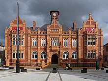
Welcome to Visit Merthyr Tydfil Places
The Walkfo guide to things to do & explore in Merthyr Tydfil
 Visit Merthyr Tydfil places using Walkfo for free guided tours of the best Merthyr Tydfil places to visit. A unique way to experience Merthyr Tydfil’s places, Walkfo allows you to explore Merthyr Tydfil as you would a museum or art gallery with audio guides.
Visiting Merthyr Tydfil Walkfo Preview
Merthyr means “martyr” in modern Welsh, but closer to the Latin martyrium: a place of worship built over a martyr’s relics . It is said to be named after Tydfil, daughter of King Brychan of Brycheiniog, who according to legend was slain by pagans about 480 CE . When you visit Merthyr Tydfil, Walkfo brings Merthyr Tydfil places to life as you travel by foot, bike, bus or car with a mobile phone & headphones.
Merthyr Tydfil Places Overview: History, Culture & Facts about Merthyr Tydfil
Visit Merthyr Tydfil – Walkfo’s stats for the places to visit
With 43 audio plaques & Merthyr Tydfil places for you to explore in the Merthyr Tydfil area, Walkfo is the world’s largest heritage & history digital plaque provider. The AI continually learns & refines facts about the best Merthyr Tydfil places to visit from travel & tourism authorities (like Wikipedia), converting history into an interactive audio experience.
Merthyr Tydfil history
Pre-history
Peoples migrating north from Europe had lived in the area for many thousands of years . Hillforts were built during the Iron Age and the tribe that inhabited them in the south of Wales was called the Silures . From their language, the Welsh language developed .
The Roman invasion
The Romans arrived in Roman Wales by about 47–53 CE and established a network of forts, with roads to link them . In 74 AD they built an auxiliary fortress at Penydarren, overlooking the River Taff . It covered an area of about three hectares, and formed part of the network of roads and fortifications . The Silures resisted this invasion fiercely from their mountain strongholds, but the Romans eventually prevailed .
The coming of Christianity
The Latin language and some Roman customs and culture became established before the withdrawal of the Roman army . The Christian religion was introduced throughout much of Wales by the Romans . It may have been introduced locally by monks from Ireland and France .
Local legends
Local tradition holds that a girl called Tydfil was an early convert to Christianity . She was pursued and murdered by a band of marauding Picts and Saxons . The girl was considered a martyr after her death in 480 . A church was eventually built on the traditional site of her burial .
The Normans
Norman barons moved in after the Norman Conquest of England, but by 1093 they occupied only the lowlands . The uplands remained in the hands of the local Welsh rulers . During this time Morlais Castle was built two miles north of the town .
Early modern Merthyr
Merthyr was little more than a village until well into the Middle Ages . In 1754, it was recorded that the valley was almost entirely populated by shepherds .
The Industrial Revolution

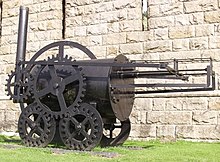
Merthyr was close to reserves of iron ore, coal, limestone, timber and water, making it an ideal site for ironworks. Small-scale iron working and coal mining had been carried out at some places in South Wales since the Tudor period, but in the wake of the Industrial Revolution the demand for iron led to the rapid expansion of Merthyr’s iron operations. By the peak of the revolution, the districts of Merthyr housed four of the greatest ironworks in the world: Dowlais Ironworks, Plymouth Ironworks, Cyfarthfa Ironworks and Penydarren. The companies were mainly owned by two dynasties, the Guest and Crawshay families. The families supported the establishment of schools for their workers. Starting in the late 1740s, land within the Merthyr district was gradually being leased for the smelting of iron to meet the growing demand, with the expansion of smaller furnaces dotted around South Wales. By 1759, with the management of John Guest, the Dowlais Ironworks was founded. This would later become the Dowlais Iron Company and also the first major works in the area. Following the success at Dowlais, Guest took a lease from the Earl of Plymouth which he used to build the Plymouth Ironworks. However, this was less of a success until the arrival in 1763 of a “Cumberland ironmaster, Anthony Bacon, who leased an area of eight miles by five for £100 a year on which he started the Cyfarthfa Ironworks and also bought the Plymouth Works”. After the death of Anthony Bacon in 1786, the ownership of the works passed to Bacon’s sons, and was divided between Richard Hill, their manager and Richard Crawshay. Hill now owned the Plymouth Iron Works and Crawshay the works at Cyfarthfa. The fourth ironworks was Penydarren, built by Francis Homfray and his son Samuel Homfray in 1784. It was the need to export goods from Cyfarthfa that led to the construction of the Glamorganshire Canal running from their works right down the valley to Cardiff Bay, stimulating other businesses along the way. During the first few decades of the 19th century, the ironworks at Cyfarthfa (and neighbouring Dowlais) continued to expand, and at their height were the most productive ironworks in the world: 50,000 tons of rails left just one ironworks in 1844, for the railways across Russia to Siberia. With the growing industry in Merthyr, several railway companies established routes linking the works with ports and other parts of Britain. They included the Brecon and Merthyr Railway, Vale of Neath Railway, Taff Vale Railway and Great Western Railway. They often shared routes to allow access to coal mines and ironworks through rugged country, which presented great engineering challenges. According to David Williams, in 1804, the world’s first railway steam locomotive, “The Iron Horse”, developed by the Cornish engineer Richard Trevithick, pulled 10 tons of iron with passengers on the new Merthyr Tramroad from Penydarren to Quakers Yard. He also claims that this was the “first ‘railway’ and the work of George Stephenson was merely an improvement upon it”. A replica of this locomotive is in the National Waterfront Museum in Swansea. The tramway passed through what is arguably the oldest railway tunnel in the world, part of which can be seen alongside Pentrebach Road at the lower end of the town. The demand for iron was also fuelled by the Royal Navy, which needed cannon for its ships, and later by the railways. In 1802, Admiral Lord Nelson visited Merthyr to witness cannon being made. Famously, upon visiting Merthyr in 1850, Thomas Carlyle wrote that the town was filled with such “unguided, hard-worked, fierce, and miserable-looking sons of Adam I never saw before. Ah me! It is like a vision of Hell, and will never leave me, that of these poor creatures broiling, all in sweat and dirt, amid their furnaces, pits, and rolling mills.” China was the name given to a nineteenth-century slum in the Pont-Storehouse area of Merthyr Tydfil. This was not a ‘Chinatown’ in the modern sense, and its residents were mainly English, Irish and Welsh. The inhabitants of China were seen as a separate class, away from the respectable areas of Merthyr, and were clearly recognisable by their lifestyle and appearance. In his article, In search of the Celestial Empire, historian Keith Strange compares China to areas of Liverpool, Nottingham and Derby, and states that this area was just as bad if not worse than those “little Sodoms”. The worst of housing conditions were to be found in this area, and China was also home to what many regarded as a criminal class. The inhabitants became known as the Chinese and formed a society that became known as the “Empire”. There were at least 1,500 people living in the slum, the inhabitants of which were the poorest of society and had a bad reputation. Their living conditions were some of the most squalid in Britain. The slum was based around narrow streets, badly ventilated and full of crowded houses that led to festering diseases. China became known as “Little Hell” and was notorious for having no toilets but open sewers, which caused diseases such as cholera and typhoid. Lice were common, especially amongst workers who worked and slept side by side in the cramped conditions of the slum. These conditions were a concern for health visitors and housing inspectors who visited its dirty streets. Some of the most memorable and detested dwellings in the slum were the cellars, which were mere one or two-roomed dwellings close together, and often with an outrageous number of inhabitants. In the 19th century, people lived in cellars only if they could not afford anything better; or perhaps they preferred being within four cell walls as they had proper shelter and were fed daily. Poor living conditions and poverty led to crime. Perhaps fewer children would have committed crimes if the standard of living had been higher. Some of these children were living with their families in these desperate conditions, but there were also numerous homeless, destitute children living on the streets. Many children were turned out of their home and left to fend for themselves at an early age, and many more ran away because of ill treatment. Many youngsters who had experienced the living conditions in China’s slum had grown up in a culture of poverty and often saw criminal offences, such as petty theft, as the only way to get regular meals. These meals were provided in the warmth of a prison cell, conditions many were unfamiliar with. Living conditions were so bad in China’s slums that for many young offenders sent to prison, the prospect of regular meals and a roof over their head was an improvement on their normal living conditions. With the Industrial Revolution came a sharp decline in young men working in agriculture, who were attracted by higher wages paid in industries such as iron. In 1829, the depression hit Merthyr hard, as ironmasters responded with dismissals, wage cuts and short-term working. Any sudden downturn in the market plunged workers into hardship, widening the class distinctions. The Merthyr Rising of 1831 was precipitated by ruthless collection of debts, frequent wage reductions, and imposition of truck shops. Some workers were paid in specially minted coins or credit notes known as “truck”, which could be spent only at shops owned by their employers. Many workers objected to the price and quality of goods sold there. Throughout May 1831, the coal miners and others who worked for William Crawshay took to the streets of Merthyr Tydfil, calling for reform, and protesting against the lowering of their wages and general unemployment. Between 7,000 and 10,000 workers marched, and for four days magistrates and ironmasters were under siege in the Castle Hotel, with the protesters effectively controlling the town. Soldiers called in from Brecon clashed with the rioters, and several on both sides were killed. Despite the hope of negotiating with the owners, the skilled workers lost control of the movement. Several supposed leaders of the riots were arrested. One of them, popularly known as Dic Penderyn, was hanged for stabbing a soldier in the leg, becoming known as the first local working-class martyr. It was claimed in 1876 that it was not Lewis who stabbed Black, but another man, Ianto Parker, who fled to America after the incident to avoid prosecution. Such claims have never been fully verified, although Lewis’s innocence is widely accepted in Merthyr. The Chartist movement of 1831 did not consider the reforms put forward by The Reform Act of 1832 to be extensive enough.
The decline of coal and iron

The population of Merthyr reached 51,949 in 1861, but then went into decline for several years . Penydarren closed in 1859 and Plymouth in 1880; thereafter some ironworkers migrated to the U.S. or Ukraine . In the 1870s the advent of coal mining to the south of the town gave renewed impetus to the local economy and population growth .
Post-Second World War
Merthyr Tydfil County Borough Council announced a bid to apply for city status in 2021 . The declining coal and iron industries gave space for new businesses to start up there and grow . The strong growth of employment of women after the Second World War can be seen as a result of the introduction of light manufacturing and consumer-based business .
Merthyr Tydfil culture & places
Merthyr Tydfil hosted the National Eisteddfod in 1881 and 1901. Several choirs perform locally and abroad and in the media. Several bands have achieved national success, including The Blackout and Midasuno.
Why visit Merthyr Tydfil with Walkfo Travel Guide App?
 You can visit Merthyr Tydfil places with Walkfo Merthyr Tydfil to hear history at Merthyr Tydfil’s places whilst walking around using the free digital tour app. Walkfo Merthyr Tydfil has 43 places to visit in our interactive Merthyr Tydfil map, with amazing history, culture & travel facts you can explore the same way you would at a museum or art gallery with information audio headset. With Walkfo, you can travel by foot, bike or bus throughout Merthyr Tydfil, being in the moment, without digital distraction or limits to a specific walking route. Our historic audio walks, National Trust interactive audio experiences, digital tour guides for English Heritage locations are available at Merthyr Tydfil places, with a AI tour guide to help you get the best from a visit to Merthyr Tydfil & the surrounding areas.
“Curated content for millions of locations across the UK, with 43 audio facts unique to Merthyr Tydfil places in an interactive Merthyr Tydfil map you can explore.”
Walkfo: Visit Merthyr Tydfil Places Map
43 tourist, history, culture & geography spots
Merthyr Tydfil historic spots | Merthyr Tydfil tourist destinations | Merthyr Tydfil plaques | Merthyr Tydfil geographic features |
| Walkfo Merthyr Tydfil tourism map key: places to see & visit like National Trust sites, Blue Plaques, English Heritage locations & top tourist destinations in Merthyr Tydfil | |||
Best Merthyr Tydfil places to visit
Merthyr Tydfil has places to explore by foot, bike or bus. Below are a selection of the varied Merthyr Tydfil’s destinations you can visit with additional content available at the Walkfo Merthyr Tydfil’s information audio spots:

Gurnos
Gurnos is a community of Merthyr Tydfil County Borough in Wales. The population in 2011 was 5,280. It consists principally of the Gurno Estate.

Joseph Parry’s Cottage
Joseph Parry’s Cottage, also known as 4 Chapel Row, is a cottage in Merthyr Tydfil, South Wales. It was built in the early 19th century for ironworkers and is now open to the public as a museum.

Morlais Castle
Morlais Castle was first begun by Gilbert de Clare, 3rd Earl of Gloucester in 1290. The castle was captured by Madog ap Llywelyn in 1294 and is believed to have never been fully completed. The location was too remote and exposed to serve as a residence.

Canolfan Soar
Canolfan Soar is a Grade II-listed community facility in Merthyr Tydfil, Wales, that includes a theatre and other facilities. It was converted from the closed Grade II listed, eighteenth-century, Zoar Chapel in the first decade of the twenty-first century.

Merthyr Tydfil bus station
Merthyr Tydfil bus station is the main operator at the station. Main operator is Stagecoach South Wales. NAT Group and First Call Travel also run services. The former bus station closed and was demolished.
![]()
The Wern
The Wern is a sports stadium in Merthyr Tydfil, Wales. Opened in 1958, the stadium is home to rugby union and rugby league club South Wales Ironmen. The stadium is a combination of seating and standing with a capacity of 4,500.

Merthyr Synagogue
The former Merthyr Synagogue is located on Bryntirion Road in the Thomastown section of Merthry Tydfil. It is a Grade II listed building and is the oldest purpose-built synagogue still standing in Wales.

Ffos-y-fran Land Reclamation Scheme
The Ffos-y-fran Land Reclamation Scheme is a major opencast coaling operation to the north-east of Merthyr Tydfil in South Wales. It will extract 10 million tonnes of coal over 15 years, the revenues from which will redevelop the current former industrial workings into residential and recreational use. The opencast coal mine has provoked criticism at a local and national scale.

The Hoover Factory, Pentrebach
The Hoover Factory, situated in Pentrebach, Merthyr Tydfil, Wales, opened on 19 October 1948 in order to manufacture Hoover washing machines. The initial workforce consisted of only 350 people but throughout the years, the growth of the company saw this figure rise to 5,000 in the 1960s and 70s.

Mynydd Cilfach-yr-encil
Mynydd Cilfach-yr-encil is the high point of the ridge of high ground between Taff Vale and Cwm Bargod in the Valleys region of South Wales. It lies within the unitary area of Merthyr Tydfil.
Visit Merthyr Tydfil plaques
 2
2
plaques
here Merthyr Tydfil has 2 physical plaques in tourist plaque schemes for you to explore via Walkfo Merthyr Tydfil plaques audio map when visiting. Plaques like National Heritage’s “Blue Plaques” provide visual geo-markers to highlight points-of-interest at the places where they happened – and Walkfo’s AI has researched additional, deeper content when you visit Merthyr Tydfil using the app. Experience the history of a location when Walkfo local tourist guide app triggers audio close to each Merthyr Tydfil plaque. Explore Plaques & History has a complete list of Hartlepool’s plaques & Hartlepool history plaque map.


 Trying to encourage visitors to Merthyr Tydfil?