Welcome to Visit Merseybank Places The Walkfo guide to things to do & explore in Merseybank
Visit Merseybank places using Walkfo for free guided tours of the best Merseybank places to visit. A unique way to experience Merseybank’s places, Walkfo allows you to explore Merseybank as you would a museum or art gallery with audio guides.
Visiting Merseybank Walkfo Preview Merseybank is a suburb of Chorlton-cum-Hardy situated towards West Didsbury 4 miles south of Manchester city centre . When you visit Merseybank, Walkfo brings Merseybank places to life as you travel by foot, bike, bus or car with a mobile phone & headphones.
Merseybank Places Overview: History, Culture & Facts about Merseybank
Visit Merseybank – Walkfo’s stats for the places to visit
With 128 audio plaques & Merseybank places for you to explore in the Merseybank area, Walkfo is the world’s largest heritage & history digital plaque provider. The AI continually learns & refines facts about the best Merseybank places to visit from travel & tourism authorities (like Wikipedia), converting history into an interactive audio experience.
Why visit Merseybank with Walkfo Travel Guide App?
You can visit Merseybank places with Walkfo Merseybank to hear history at Merseybank’s places whilst walking around using the free digital tour app. Walkfo Merseybank has 128 places to visit in our interactive Merseybank map, with amazing history, culture & travel facts you can explore the same way you would at a museum or art gallery with information audio headset. With Walkfo, you can travel by foot, bike or bus throughout Merseybank, being in the moment, without digital distraction or limits to a specific walking route. Our historic audio walks, National Trust interactive audio experiences, digital tour guides for English Heritage locations are available at Merseybank places, with a AI tour guide to help you get the best from a visit to Merseybank & the surrounding areas.
“Curated content for millions of locations across the UK, with 128 audio facts unique to Merseybank places in an interactive Merseybank map you can explore.”
Walkfo Merseybank tourism map key: places to see & visit like National Trust sites, Blue Plaques, English Heritage locations & top tourist destinations in Merseybank
Best Merseybank places to visit
Merseybank has places to explore by foot, bike or bus. Below are a selection of the varied Merseybank’s destinations you can visit with additional content available at the Walkfo Merseybank’s information audio spots:
Hough End Hall Hough End Hall is a historic house now in Chorlton-cum-Hardy, (originally in Withington), Manchester . It was built in 1596 during the reign of Queen Elizabeth I by Sir Nicholas Mosley . The Mosleys were an influential Mancunian family from the 16th century onwards .
Chorlton Poor Law Union Chorlton Poor Law Union was founded in January 1837 in response to the Poor Law Amendment Act 1834 . It was overseen by an elected board of 19 guardians representing the 12 parishes in the area it served .
Southern Cemetery, Manchester Southern Cemetery is a large municipal cemetery in Chorlton-cum-Hardy, Manchester, England . It opened in 1879 and is owned and administered by Manchester City Council . It is the second largest cemetery in Europe and the largest in the UK .
St Ann’s, Stretford St Ann’s Church, Stretford is a Grade II listed Roman Catholic church . It was constructed between 1862 and 1863, on the east side of the A56 Chester Road . The parish functions under the jurisdiction of the Roman Catholic Diocese of Salford .
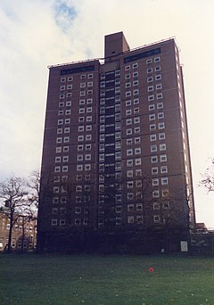
Owens Park Owens Park is a large hall of residence located in the Fallowfield district of the city of Manchester . The hall is owned by the University of Manchester and houses 1,056 students . The terms ‘Owens Park’ and ‘Fallowfield Campus’ are sometimes used interchangeably .
Fallowfield Campus Fallowfield Campus is the main residential campus of the University of Manchester . It is located 2 miles (3 km) south of the main university site . The campus is connected by Wilmslow Road and the A34 .
Municipal Borough of Sale Sale was, from 1867 to 1974, a district in Cheshire. The district had the status of local government district, urban district and municipal borough. Its area now forms part of the Metropolitan Borough of Trafford.
Heaton Mersey Heaton Mersey is a mostly residential area and commuter zone for Manchester. It is situated on the north-western border of Stockport, adjacent to Didsbury and Burnage in Manchester. Heaton Norris, Heaton Chapel and Heaton Moor are collectively known as the Four Heatons.
Parrs Wood Parrs Wood is an area of East Didsbury, in south Manchester, England. It was formerly the estate surrounding Parrrs Wood House, an 18th-century Georgian villa. Today the area incorporates part of Wilmslow Road and is home to a Tesco supermarket.
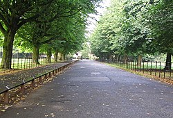
Wythenshawe Park Wythenshawe Park is a Green Flag awarded park covering 270 acres. The park features woodland, bedding, grassland and meadows, sporting facilities, a community farm and a horticulture centre.
Visit Merseybank plaques
27 plaques hereMerseybank has 27 physical plaques in tourist plaque schemes for you to explore via Walkfo Merseybank plaques audio map when visiting. Plaques like National Heritage’s “Blue Plaques” provide visual geo-markers to highlight points-of-interest at the places where they happened – and Walkfo’s AI has researched additional, deeper content when you visit Merseybank using the app. Experience the history of a location when Walkfo local tourist guide app triggers audio close to each Merseybank plaque. Explore Plaques & History has a complete list of Hartlepool’s plaques & Hartlepool history plaque map.
Experience Merseybank audio walks & tours
Walkfo guides for things to do / places to visit in Merseybank allows exploration as you would do an art gallery or museum. Walk close to one of Merseybank’s 128 historic places & our digital tour guide will create an audio story for that spot. With headphone connected, you can explore Merseybank freely by foot, bike or bus – with your own personal tour guide in your pocket.
Explore Merseybank Map App
Our visit Merseybank map shows you things-to-do & places you can visit in Merseybank & surrounding areas using the Walkfo digital audio tour guide app. Each spot has plaque, building, street or area information on history, culture or tourism.
You can set your Walkfo’s Merseybank tourist map to find historic & tourism spots within 1km, 3km & 5km of the Merseybank centre, depending on how far you plan to explore whilst you visit Merseybank area at LONG:-2.263, LAT:53.423.
Walkfo App
Walkfo
Walkfo is free to download & use (for a limited time period), so if you are looking to explore Merseybank, go to your App Store to search for “Walkfo” or follow a links below and install on your mobile phone. Walkfo is designed for use with headphones or AirPods, so you can walk & explore whilst learning about the things around you without digital distraction.
Things to do & visit in Merseybank / surrounding areas
● Northen Etchells ● Benchill tram stop ● Wythenshawe Amateurs F.C. ● Benchill ● Gatley ● Sharston Hall ● Sharston ● Menorah Synagogue ● Stockport Etchells ● Haveley tram stop ● Wythenshawe Bus Garage ● Rose Hill, Northenden ● Newall Green ● Micker Brook ● Barnes Hospital, Cheadle ● Old Bedians ● Martinscroft tram stop ● Baguley ● Ladybrook Valley ● Church of St Wilfrid, Northenden ● Roundthorn tram stop ● British Muslim Heritage Centre ● Manley Hall, Manchester ● Chorlton tram stop ● Unicorn Grocery ● Whalley Range, Manchester ● Chorlton-cum-Hardy ● Hough End tram stop ● Stretford Memorial Hospital ● Firswood tram stop
● Hough End Hall ● Firswood ● Chorlton Poor Law Union ● Alexandra Park, Manchester ● Chorlton (ward) ● St Clement’s Church, Chorlton-cum-Hardy ● Chorlton Park Apartments ● Alexandra Park Aerodrome ● Chorltonville ● Chorlton Park (ward) ● Old Trafford tram stop ● Withington tram stop ● Barlow Moor ● West Didsbury & Chorlton A.F.C. ● 2018 Moss Side mass shooting ● Howard Harker ● Hardy Farm tram stop ● Moss Side ● Southern Cemetery, Manchester ● Gorse Hill ● The Kippax ● Old Moat ● Old Moat (ward) ● Chorlton-cum-Hardy Golf Club ● Barlow Hall ● Chorlton Brook ● Christ Church, West Didsbury ● Merseybank ● St Ann’s, Stretford ● Stretford tram stop ● Withington Community Hospital ● Holy Trinity Platt Church ● Platt Fields Park ● Trafford ● Cine City, Withington ● Sale Water Park tram stop ● Sale Water Park ● Withington ● Wolfson Molecular Imaging Centre ● Didsbury Mosque ● St Paul’s Church, Withington ● South Manchester Synagogue ● XS Malarkey ● Owens Park ● Fallowfield Campus ● Fallowfield Stadium ● Sale Town Hall ● Sale tram stop ● Sale, Greater Manchester ● Municipal Borough of Sale ● Ladybarn ● Withington (ward) ● The Christie NHS Foundation Trust ● Christie Hospital ● Heaton Mersey ● Parrs Wood House ● East Didsbury tram stop ● Parrs Wood ● Shirley Institute ● Northenden ● Wythenshawe Park ● Wythenshawe Hall ● Wythenshawe community farm ● Baguley tram stop ● Northern Moor ● Burnage (ward) ● Burnage ● Wythenshawe Town F.C. ● Manchester (Wythenshawe) Aerodrome ● Church of St Michael and All Angels, Northenden ● Church of St John the Divine, Brooklands ● Brooklands (Trafford ward) ● Brooklands (Manchester ward) ● Walkden Gardens ● Church of St Nicholas, Burnage ● Capitol Theatre, Manchester ● Didsbury East (ward) ● Didsbury Village tram stop ● Didsbury Campus ● St Paul’s Methodist Church, Didsbury ● Fletcher Moss Botanical Garden ● Church of St James, Didsbury ● Didsbury ● West Didsbury tram stop ● Northern Lawn Tennis Club ● Didsbury West (ward) ● Northern Moor tram stop ● Wythenshawe Park tram stop ● Fletcher Moss Rangers F.C. ● Wythenshawe ● Baguley Hall ● Fallowfield ● The Towers (Manchester) ● Brooklands, Greater Manchester ● Mural of Marcus Rashford ● Rookwood Cricket Ground, Sale
Getting to / around Merseybank – transport link, station & street map
Getting around in Merseybank using public transportation may include road, street, train, underground, bus or tram transport options. Walkfo has identified the following Merseybank places with historic / cultural / factual content when you visit:
Local Merseybank Public Transport Stations
Merseybank Notable Streets & Road Destinations
Gatley railway station
Northenden railway station
Wilbraham Road railway station
Withington and West Didsbury railway station
Fallowfield railway station
Mauldeth Road railway station
Heaton Mersey railway station
Cheadle North railway station
East Didsbury railway station
Didsbury railway station
Burnage railway station
Maine Road F.C.
St Werburgh’s Road tram stop
Barlow Moor Road tram stop
A5103 road
Maine Road
Burton Road tram stop
Dane Road tram stop
Wilmslow Road bus corridor
Wilmslow Road
Moor Road tram stop
Heywood Road
[transportsummary]
Local Merseybank historians & Merseybank tour guides
Trying to encourage visitors to Merseybank? Walkfo has millions audio places already available but Walkfo Creator gives Merseybank’s places, attractions & landmarks ability to create their own unique outdoor audio museums & using our simple & easy to use Walkfo Creator. – Creating a new audio experience for your Merseybank place is free* and quick (15+ minutes if you prepare text content) to use, with Walkfo Creator doing the hard work of generating AI audio files for geo-spots from the text you provide with a simply click on a map. – The 100 Amazing Merseybank Places is just one example of an outdoor museum created using Walkfo Creator (pictured to the left) for people to safely explore during Covid-19 times whilst visiting a city. Our tool is open to tourism organisations, travel destinations & National Trust locations to create their own audio walks to offer free when people visit Merseybank destinations. – Walkfo itself is looking to partner with websites offering things-to-do / what’s on events listings to enhance the content of our ‘visit-Merseybank’ web pages (for example: www.visitMerseybank.com). If you are interested in partnering, please contact us to discuss options.
* Walkfo Creator is free to use for a limited number of audio spots within a map with a license fee applicable when more than 20 audio spots within location walk are created. v1.1336
 Visit Merseybank places using Walkfo for free guided tours of the best Merseybank places to visit. A unique way to experience Merseybank’s places, Walkfo allows you to explore Merseybank as you would a museum or art gallery with audio guides.
 You can visit Merseybank places with Walkfo Merseybank to hear history at Merseybank’s places whilst walking around using the free digital tour app. Walkfo Merseybank has 128 places to visit in our interactive Merseybank map, with amazing history, culture & travel facts you can explore the same way you would at a museum or art gallery with information audio headset. With Walkfo, you can travel by foot, bike or bus throughout Merseybank, being in the moment, without digital distraction or limits to a specific walking route. Our historic audio walks, National Trust interactive audio experiences, digital tour guides for English Heritage locations are available at Merseybank places, with a AI tour guide to help you get the best from a visit to Merseybank & the surrounding areas.


 27
27


 Trying to encourage visitors to Merseybank?