Welcome to Visit Marloes Places
The Walkfo guide to things to do & explore in Marloes
 Visit Marloes places using Walkfo for free guided tours of the best Marloes places to visit. A unique way to experience Marloes’s places, Walkfo allows you to explore Marloes as you would a museum or art gallery with audio guides.
Visiting Marloes Walkfo Preview
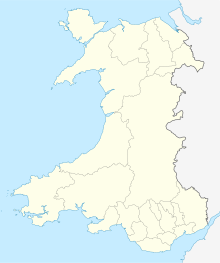
Marloes is 7 miles (11 km) west of Milford Haven and forms the western tip of the southern shore of St Brides Bay. It is within part of the Pembrokeshire Coast National Park. The parish has 6 miles (9.7 km) of mainland coastline. When you visit Marloes, Walkfo brings Marloes places to life as you travel by foot, bike, bus or car with a mobile phone & headphones.
Marloes Places Overview: History, Culture & Facts about Marloes
Visit Marloes – Walkfo’s stats for the places to visit
With 13 audio plaques & Marloes places for you to explore in the Marloes area, Walkfo is the world’s largest heritage & history digital plaque provider. The AI continually learns & refines facts about the best Marloes places to visit from travel & tourism authorities (like Wikipedia), converting history into an interactive audio experience.
Marloes history
Every place in Wales was described by Samuel Lewis in his 1833 book A Topographical Dictionary of Wales. His description of Marloes is as follows: Marlais (MARLOES), a parish in the hundred of RHÔS, county of PEMBROKE, SOUTH WALES, containing 427 inhabitants.
Marloes geography / climate

Marloes includes the island of Skomer, accessible from Martin’s Haven at the tip of the peninsula, and the small islands of Grassholm and Gateholm. The National Trust owns the western half of the Peninsula, including the open-access deer park on its western tip. The deer park, which was originally part of the Kensington estate of St Brides, has never contained any deer.
Why visit Marloes with Walkfo Travel Guide App?
 You can visit Marloes places with Walkfo Marloes to hear history at Marloes’s places whilst walking around using the free digital tour app. Walkfo Marloes has 13 places to visit in our interactive Marloes map, with amazing history, culture & travel facts you can explore the same way you would at a museum or art gallery with information audio headset. With Walkfo, you can travel by foot, bike or bus throughout Marloes, being in the moment, without digital distraction or limits to a specific walking route. Our historic audio walks, National Trust interactive audio experiences, digital tour guides for English Heritage locations are available at Marloes places, with a AI tour guide to help you get the best from a visit to Marloes & the surrounding areas.
“Curated content for millions of locations across the UK, with 13 audio facts unique to Marloes places in an interactive Marloes map you can explore.”
Walkfo: Visit Marloes Places Map
13 tourist, history, culture & geography spots
Marloes historic spots | Marloes tourist destinations | Marloes plaques | Marloes geographic features |
| Walkfo Marloes tourism map key: places to see & visit like National Trust sites, Blue Plaques, English Heritage locations & top tourist destinations in Marloes | |||
Best Marloes places to visit
Marloes has places to explore by foot, bike or bus. Below are a selection of the varied Marloes’s destinations you can visit with additional content available at the Walkfo Marloes’s information audio spots:
 | Marloes Mere Marloes Mere is a Site of Special Scientific Interest (or SSSI) in Pembrokeshire, South Wales. The site has an area of 17.17 hectares (42.4 acres) and is managed by Natural Resources Wales. |
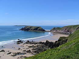 | Gateholm Gateholm or Gateholm Island is a small tidal island off the south west coast of Pembrokeshire. It is owned by the National Trust as part of their Marloes Sands and Mere estate. |
 | Dale Castle Dale Castle is a 13th-century castle located close to the village of Dale in Pembrokeshire, Wales. In 1910, part of the castle was removed and other parts incorporated into a new private dwelling house. |
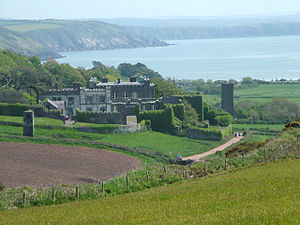
 | St Brides Castle St Brides Castle is a 19th-century castellated Baronial Style mansion in Pembrokeshire, southwest Wales. |
 | Dale Fort Dale Fort is a mid-nineteenth century coastal artillery fort at Dale Head, Pembrokeshire, to the west of Milford Haven in Wales. It is one of the centres run by Field Studies Council and offers residential and non residential fieldwork for schools, colleges and universities. |
Visit Marloes plaques
 0
0
plaques
here Marloes has 0 physical plaques in tourist plaque schemes for you to explore via Walkfo Marloes plaques audio map when visiting. Plaques like National Heritage’s “Blue Plaques” provide visual geo-markers to highlight points-of-interest at the places where they happened – and Walkfo’s AI has researched additional, deeper content when you visit Marloes using the app. Experience the history of a location when Walkfo local tourist guide app triggers audio close to each Marloes plaque. Currently No Physical Plaques.


 Trying to encourage visitors to Marloes?