Welcome to Visit Loose, Kent Places
The Walkfo guide to things to do & explore in Loose, Kent
 Visit Loose, Kent places using Walkfo for free guided tours of the best Loose, Kent places to visit. A unique way to experience Loose, Kent’s places, Walkfo allows you to explore Loose, Kent as you would a museum or art gallery with audio guides.
Visiting Loose, Kent Walkfo Preview
Loose is 2 miles (3 km) south of Maidstone, Kent, situated at the head of the Loose Valley. The fast- flowing River Loose runs through the centre of the village and once supported a paper-making industry. An area round the village is also known as Loose. When you visit Loose, Kent, Walkfo brings Loose, Kent places to life as you travel by foot, bike, bus or car with a mobile phone & headphones.
Loose, Kent Places Overview: History, Culture & Facts about Loose, Kent
Visit Loose, Kent – Walkfo’s stats for the places to visit
With 37 audio plaques & Loose, Kent places for you to explore in the Loose, Kent area, Walkfo is the world’s largest heritage & history digital plaque provider. The AI continually learns & refines facts about the best Loose, Kent places to visit from travel & tourism authorities (like Wikipedia), converting history into an interactive audio experience.
Loose, Kent history

Loose, Boughton Monchelsea and Bockingford developed around the seven mills powered by the Loose Stream. There are several remains of the mills, including millraces at Leg O’Mutton Pond, Gurney’s Mill, Loose Village Mill in Bridge Street, the mill ponds at Little and Great Ivy mills.
Why visit Loose, Kent with Walkfo Travel Guide App?
 You can visit Loose, Kent places with Walkfo Loose, Kent to hear history at Loose, Kent’s places whilst walking around using the free digital tour app. Walkfo Loose, Kent has 37 places to visit in our interactive Loose, Kent map, with amazing history, culture & travel facts you can explore the same way you would at a museum or art gallery with information audio headset. With Walkfo, you can travel by foot, bike or bus throughout Loose, Kent, being in the moment, without digital distraction or limits to a specific walking route. Our historic audio walks, National Trust interactive audio experiences, digital tour guides for English Heritage locations are available at Loose, Kent places, with a AI tour guide to help you get the best from a visit to Loose, Kent & the surrounding areas.
“Curated content for millions of locations across the UK, with 37 audio facts unique to Loose, Kent places in an interactive Loose, Kent map you can explore.”
Walkfo: Visit Loose, Kent Places Map
37 tourist, history, culture & geography spots
Loose, Kent historic spots | Loose, Kent tourist destinations | Loose, Kent plaques | Loose, Kent geographic features |
| Walkfo Loose, Kent tourism map key: places to see & visit like National Trust sites, Blue Plaques, English Heritage locations & top tourist destinations in Loose, Kent | |||
Best Loose, Kent places to visit
Loose, Kent has places to explore by foot, bike or bus. Below are a selection of the varied Loose, Kent’s destinations you can visit with additional content available at the Walkfo Loose, Kent’s information audio spots:

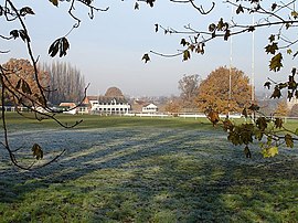
Mote Park
Mote Park is a 440-acre (1.8 km) multi-use public park in Maidstone, Kent. Includes the former stately home Mote House together with a miniature railway and boating lake. A ground of the same name within the park has also been used as a first-class cricket ground by Kent County Cricket Club.
Mote Park (cricket ground)
Mote Park, also known as The Mote, is a cricket ground in Maidstone, Kent. The ground is inside the grounds of the Mote Cricket Club and is owned by The Motes Cricket Club. It was used by Kent County Cricket Club as one of their out-grounds for county cricket matches.

Loose Stream
The Loose Stream is a tributary of the River Medway. It rises in Langley, flows through Boughton Monchelsea, Loose and enters the Medway at Tovil. The stream has been dammed in many places, resulting in many mill ponds.
![]()
Battle of Maidstone
The Battle of Maidstone (1 June 1648) was fought in the Second English Civil War. Parliamentarian troops won the battle over the defending Royalist forces.

Tithe Barn, Maidstone
The Tithe Barn in Maidstone, Kent, was constructed in the 14th century as a tithe barn for the nearby Archbishop’s Palace. It was later used as the palace’s stables. The barn is a Grade I listed building and a scheduled monument.

Hazlitt Theatre
The Hazlitt Theatre is one of the main theatres in Maidstone, Kent. It was named after the famous essayist William Hazlit, who was born in 1778. The traditional proscenium arch theatre seats 353.

Fremlin Walk
Fremlin Walk is an outdoor shopping centre in Maidstone town centre, Kent. It opened in 2005 after several years of development by Centros Miller. The original owner was Land Securities plc. Legal & General Property bought the centre in 2011 for £92 million.

Maidstone Museum
Maidstone Museum is a local authority-run museum located in Maidstone, Kent. The museum is one of three operated by Maidstone Borough Council. The building is Grade II* listed.
Visit Loose, Kent plaques
 5
5
plaques
here Loose, Kent has 5 physical plaques in tourist plaque schemes for you to explore via Walkfo Loose, Kent plaques audio map when visiting. Plaques like National Heritage’s “Blue Plaques” provide visual geo-markers to highlight points-of-interest at the places where they happened – and Walkfo’s AI has researched additional, deeper content when you visit Loose, Kent using the app. Experience the history of a location when Walkfo local tourist guide app triggers audio close to each Loose, Kent plaque. Explore Plaques & History has a complete list of Hartlepool’s plaques & Hartlepool history plaque map.


 Trying to encourage visitors to Loose, Kent?