Welcome to Visit Lockleaze Places
The Walkfo guide to things to do & explore in Lockleaze
 Visit Lockleaze places using Walkfo for free guided tours of the best Lockleaze places to visit. A unique way to experience Lockleaze’s places, Walkfo allows you to explore Lockleaze as you would a museum or art gallery with audio guides.
Visiting Lockleaze Walkfo Preview
Lockleaze is 3 miles (5 km) north of the city centre, south of Filton, east of Horfield and west of Frenchay. The suburb was developed immediately after World War II. It is a residential area of social housing built on the western flank of Purdown on a north-south axis, that was separated from Horfield by the main Bristol to South Wales railway line. When you visit Lockleaze, Walkfo brings Lockleaze places to life as you travel by foot, bike, bus or car with a mobile phone & headphones.
Lockleaze Places Overview: History, Culture & Facts about Lockleaze
Visit Lockleaze – Walkfo’s stats for the places to visit
 With 134 audio plaques & Lockleaze places for you to explore in the Lockleaze area, Walkfo is the world’s largest heritage & history digital plaque provider. The AI continually learns & refines facts about the best Lockleaze places to visit from travel & tourism authorities (like Wikipedia), converting history into an interactive audio experience.
Lockleaze history

Lockleaze Farm stood roughly where Bonnington Walk is today, between Stothard Road, Branwhite Close and Thornycroft Close. The name Lock Leaze comes from the Anglo-Saxon for a fold in a field or pasture.
Why visit Lockleaze with Walkfo Travel Guide App?
 You can visit Lockleaze places with Walkfo Lockleaze to hear history at Lockleaze’s places whilst walking around using the free digital tour app. Walkfo Lockleaze has 134 places to visit in our interactive Lockleaze map, with amazing history, culture & travel facts you can explore the same way you would at a museum or art gallery with information audio headset. With Walkfo, you can travel by foot, bike or bus throughout Lockleaze, being in the moment, without digital distraction or limits to a specific walking route. Our historic audio walks, National Trust interactive audio experiences, digital tour guides for English Heritage locations are available at Lockleaze places, with a AI tour guide to help you get the best from a visit to Lockleaze & the surrounding areas.
“Curated content for millions of locations across the UK, with 134 audio facts unique to Lockleaze places in an interactive Lockleaze map you can explore.”
Walkfo: Visit Lockleaze Places Map
134 tourist, history, culture & geography spots
Lockleaze historic spots | Lockleaze tourist destinations | Lockleaze plaques | Lockleaze geographic features |
| Walkfo Lockleaze tourism map key: places to see & visit like National Trust sites, Blue Plaques, English Heritage locations & top tourist destinations in Lockleaze | |||
Best Lockleaze places to visit
Lockleaze has places to explore by foot, bike or bus. Below are a selection of the varied Lockleaze’s destinations you can visit with additional content available at the Walkfo Lockleaze’s information audio spots:
 | St George’s Park, Bristol St George Park is a park on the eastern edge of the inner city in Bristol . Built on land that was originally The Fire Engine Farm, the park had many architectural features . The St George Library is situated on the edge the park, on Church Road . |
 | Eastville Workhouse The Eastville Workhouse was a workhouse situated at 100 Fishponds Road, in Bristol, U.K. It was converted into a home for the elderly in the 1920s and demolished in 1972 . |
 | Circomedia Circomedia is a school for contemporary circus and physical theatre based in Bristol . The school offers a variety of training courses and workshops that teach circus skills in the context of physical theatre, performance and creativity . |
 | Westmoreland House Westmoreland House was a building at Nos. 104–106 Stokes Croft, Bristol, next door to the Carriage Works . |
| Carriage Works, Bristol The Carriage Works (grid reference ST591740) are in Stokes Croft, Bristol, England . Carriage works are located in Bristol . |
 | South Purdown, Bristol South Purdown, Bristol, is an ancient green space located in north Bristol . The area of land is bordered by central Muller Road, Sir Johns Lane Allotment site, Stoke Park, Lockleaze Open Space and the Priory Hospital . It has been designated a Site of Nature Conservation Interest . |
 | Pen Park Hole Pen Park Hole is a large cavern situated underground, at the edge of Filton Golf Course. The cavern was discovered accidentally in the 17th Century and the first descent was made by Captain Sturmy in 1669. Access to the entrance is tightly controlled by Bristol City Council. |
 | North Bristol NHS Trust North Bristol NHS Trust is a National Health Service trust providing community healthcare and hospital services to Bristol, South Gloucestershire and North Somerset. Trust has over 8,000 staff delivering healthcare across Southmead Hospital, Cossham Hospital and Bristol Centre for Enablement. Medical teaching facilities are provided in association with the University of the West of England, Bristol University and Bristol University. |
 | North Fringe of Bristol The North Fringe of Bristol lies between the M4 and M5 motorways. Its eastern edge is usually defined as the M32 motorway. The area falls within South Gloucestershire Council, and is northern part of Greater Bristol. |
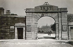 | Horfield Barracks Horfield Barracks is a former military installation in the Horfield area of Bristol. It is located near the town of Horfield and is located on the outskirts of the city. |
Visit Lockleaze plaques
 18
18
plaques
here Lockleaze has 18 physical plaques in tourist plaque schemes for you to explore via Walkfo Lockleaze plaques audio map when visiting. Plaques like National Heritage’s “Blue Plaques” provide visual geo-markers to highlight points-of-interest at the places where they happened – and Walkfo’s AI has researched additional, deeper content when you visit Lockleaze using the app. Experience the history of a location when Walkfo local tourist guide app triggers audio close to each Lockleaze plaque. Explore Plaques & History has a complete list of Hartlepool’s plaques & Hartlepool history plaque map.


 Trying to encourage visitors to Lockleaze?