Welcome to Visit Llangar Places The Walkfo guide to things to do & explore in Llangar
Visit Llangar places using Walkfo for free guided tours of the best Llangar places to visit. A unique way to experience Llangar’s places, Walkfo allows you to explore Llangar as you would a museum or art gallery with audio guides.
Visiting Llangar Walkfo Preview Llangar is 1 mile (1.6 km) south west of Corwen, its post town, and 10 miles (16 km) north east of Bala. It is situated at the confluence of the rivers Alwen and Dee, and includes the small hamlets of Bryn, Cymer, and Gwynodl. The small village stands on the road from Corwen by the Vale of Edeyrnion. When you visit Llangar, Walkfo brings Llangar places to life as you travel by foot, bike, bus or car with a mobile phone & headphones.
Llangar Places Overview: History, Culture & Facts about Llangar
Visit Llangar – Walkfo’s stats for the places to visit
With 15 audio plaques & Llangar places for you to explore in the Llangar area, Walkfo is the world’s largest heritage & history digital plaque provider. The AI continually learns & refines facts about the best Llangar places to visit from travel & tourism authorities (like Wikipedia), converting history into an interactive audio experience.
Why visit Llangar with Walkfo Travel Guide App?
You can visit Llangar places with Walkfo Llangar to hear history at Llangar’s places whilst walking around using the free digital tour app. Walkfo Llangar has 15 places to visit in our interactive Llangar map, with amazing history, culture & travel facts you can explore the same way you would at a museum or art gallery with information audio headset. With Walkfo, you can travel by foot, bike or bus throughout Llangar, being in the moment, without digital distraction or limits to a specific walking route. Our historic audio walks, National Trust interactive audio experiences, digital tour guides for English Heritage locations are available at Llangar places, with a AI tour guide to help you get the best from a visit to Llangar & the surrounding areas.
“Curated content for millions of locations across the UK, with 15 audio facts unique to Llangar places in an interactive Llangar map you can explore.”
Walkfo Llangar tourism map key: places to see & visit like National Trust sites, Blue Plaques, English Heritage locations & top tourist destinations in Llangar
Best Llangar places to visit
Llangar has places to explore by foot, bike or bus. Below are a selection of the varied Llangar’s destinations you can visit with additional content available at the Walkfo Llangar’s information audio spots:
Edeirnion Edeirnion or Edeyrnion is an ancient commote of medieval Wales in the cantref of Penllyn. It was nominally a part of the Kingdom of Powys but was often subject to border intrusions by the neighbouring Kingdom of Gwynedd. The area still exists as a bro, or region, located around Corwen and near the Berwyn Range.
Corwen F.C. Corwen F.C. is a Welsh football club based in Corwen, Denbighshire. Corwen play in the Ardal Leagues North East, the third tier of the Welsh football pyramid.
SS Mael and Sulien’s Church, Corwen Saint Mael and Saint Sulien’s Church is located in the town of Corwen in Denbighshire in Wales. It was formerly in the ancient county of Merionethshire.
Rhug Rhug (normally Y Rug in Welsh; sometimes given the antiquarian spelling Rûg) is a township in the parish of Corwen, Denbighshire, Wales. It was formerly in the old cantref of Edeirnion and later a part of Merionethshire. It is situated near the River Dee, under Berwyn range.
Caer Drewyn Caer Drewyn is an early Iron Age hillfort to the north of the town of Corwen, Denbighshire. It has a large stone rampart with entrances on the west and north sides; there is a guard chamber within the north-east entrance.
Llangar Church Llangar Church, or All Saints Old Parish Church, is a grade I Listed Building. It is now under the guardianship of Cadw and is a Scheduled Monument.
Plas Uchaf Plas Uchaf (English: Upper Hall) is a 15th-century cruck-and-aisle-truss hall house. It is 1.5 miles (2.4 km) south-west of Corwen, Denbighshire, Wales and 1.6 km north of Cynwyd.
Cynwyd Forest Quarry The Cynwyd Forest Quarry is a Site of Special Scientific Interest (SSSI) located aside a track in North Wales. It exposes Late Ordovician micaceous siltstones and mudstones of the Dolhir Formation (Ashgill Series, Rawtheyan Stage) which yields a rich shelly (brachiopod) fauna. Trilobites are represented by several genera although the fauna is dominated by Gravicalymene arcuata Price, 1982.
Visit Llangar plaques
1 plaques hereLlangar has 1 physical plaques in tourist plaque schemes for you to explore via Walkfo Llangar plaques audio map when visiting. Plaques like National Heritage’s “Blue Plaques” provide visual geo-markers to highlight points-of-interest at the places where they happened – and Walkfo’s AI has researched additional, deeper content when you visit Llangar using the app. Experience the history of a location when Walkfo local tourist guide app triggers audio close to each Llangar plaque. Explore Plaques & History has a complete list of Hartlepool’s plaques & Hartlepool history plaque map.
Experience Llangar audio walks & tours
Walkfo guides for things to do / places to visit in Llangar allows exploration as you would do an art gallery or museum. Walk close to one of Llangar’s 15 historic places & our digital tour guide will create an audio story for that spot. With headphone connected, you can explore Llangar freely by foot, bike or bus – with your own personal tour guide in your pocket.
Explore Llangar Map App
Our visit Llangar map shows you things-to-do & places you can visit in Llangar & surrounding areas using the Walkfo digital audio tour guide app. Each spot has plaque, building, street or area information on history, culture or tourism.
You can set your Walkfo’s Llangar tourist map to find historic & tourism spots within 1km, 3km & 5km of the Llangar centre, depending on how far you plan to explore whilst you visit Llangar area at LONG:-3.397, LAT:52.971.
Walkfo App
Walkfo
Walkfo is free to download & use (for a limited time period), so if you are looking to explore Llangar, go to your App Store to search for “Walkfo” or follow a links below and install on your mobile phone. Walkfo is designed for use with headphones or AirPods, so you can walk & explore whilst learning about the things around you without digital distraction.
Getting to / around Llangar – transport link, station & street map
Getting around in Llangar using public transportation may include road, street, train, underground, bus or tram transport options. Walkfo has identified the following Llangar places with historic / cultural / factual content when you visit:
Local Llangar Public Transport Stations
Llangar Notable Streets & Road Destinations
Corwen railway station
Corwen East railway station
Bonwm Halt railway station
Cynwyd railway station (Wales)
A494 road
[transportsummary]
Local Llangar historians & Llangar tour guides
Trying to encourage visitors to Llangar? Walkfo has millions audio places already available but Walkfo Creator gives Llangar’s places, attractions & landmarks ability to create their own unique outdoor audio museums & using our simple & easy to use Walkfo Creator. – Creating a new audio experience for your Llangar place is free* and quick (15+ minutes if you prepare text content) to use, with Walkfo Creator doing the hard work of generating AI audio files for geo-spots from the text you provide with a simply click on a map. – The 100 Amazing Llangar Places is just one example of an outdoor museum created using Walkfo Creator (pictured to the left) for people to safely explore during Covid-19 times whilst visiting a city. Our tool is open to tourism organisations, travel destinations & National Trust locations to create their own audio walks to offer free when people visit Llangar destinations. – Walkfo itself is looking to partner with websites offering things-to-do / what’s on events listings to enhance the content of our ‘visit-Llangar’ web pages (for example: www.visitLlangar.com). If you are interested in partnering, please contact us to discuss options.
* Walkfo Creator is free to use for a limited number of audio spots within a map with a license fee applicable when more than 20 audio spots within location walk are created. v1.1336
 Visit Llangar places using Walkfo for free guided tours of the best Llangar places to visit. A unique way to experience Llangar’s places, Walkfo allows you to explore Llangar as you would a museum or art gallery with audio guides.
 You can visit Llangar places with Walkfo Llangar to hear history at Llangar’s places whilst walking around using the free digital tour app. Walkfo Llangar has 15 places to visit in our interactive Llangar map, with amazing history, culture & travel facts you can explore the same way you would at a museum or art gallery with information audio headset. With Walkfo, you can travel by foot, bike or bus throughout Llangar, being in the moment, without digital distraction or limits to a specific walking route. Our historic audio walks, National Trust interactive audio experiences, digital tour guides for English Heritage locations are available at Llangar places, with a AI tour guide to help you get the best from a visit to Llangar & the surrounding areas.
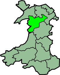


 1
1


 Trying to encourage visitors to Llangar?