Welcome to Visit Leigh-on-Mendip Places The Walkfo guide to things to do & explore in Leigh-on-Mendip
Visit Leigh-on-Mendip places using Walkfo for free guided tours of the best Leigh-on-Mendip places to visit. A unique way to experience Leigh-on-Mendip’s places, Walkfo allows you to explore Leigh-on-Mendip as you would a museum or art gallery with audio guides.
Visiting Leigh-on-Mendip Walkfo Preview Leigh-on-Mendip or Leigh upon Mendip (on Ordnance Survey maps) is a small village on the Mendip Hills in Somerset. It lies roughly equidistant from Frome, Radstock and Shepton Mallet at about 5 miles (8 km) from each town. When you visit Leigh-on-Mendip, Walkfo brings Leigh-on-Mendip places to life as you travel by foot, bike, bus or car with a mobile phone & headphones.
Leigh-on-Mendip Places Overview: History, Culture & Facts about Leigh-on-Mendip
Visit Leigh-on-Mendip – Walkfo’s stats for the places to visit
With 41 audio plaques & Leigh-on-Mendip places for you to explore in the Leigh-on-Mendip area, Walkfo is the world’s largest heritage & history digital plaque provider. The AI continually learns & refines facts about the best Leigh-on-Mendip places to visit from travel & tourism authorities (like Wikipedia), converting history into an interactive audio experience.
Leigh-on-Mendip history
The name of this village is pronounced lye or lie by local residents rather than lee, and probably comes from the Old English meaning grove or glade. The estate formed part of the manor and liberty of Mells and was held by Glastonbury Abbey from Saxon times until the dissolution of the monasteries. On 19 June 1643 the village was the site of a skirmish in the English Civil War.
Why visit Leigh-on-Mendip with Walkfo Travel Guide App?
You can visit Leigh-on-Mendip places with Walkfo Leigh-on-Mendip to hear history at Leigh-on-Mendip’s places whilst walking around using the free digital tour app. Walkfo Leigh-on-Mendip has 41 places to visit in our interactive Leigh-on-Mendip map, with amazing history, culture & travel facts you can explore the same way you would at a museum or art gallery with information audio headset. With Walkfo, you can travel by foot, bike or bus throughout Leigh-on-Mendip, being in the moment, without digital distraction or limits to a specific walking route. Our historic audio walks, National Trust interactive audio experiences, digital tour guides for English Heritage locations are available at Leigh-on-Mendip places, with a AI tour guide to help you get the best from a visit to Leigh-on-Mendip & the surrounding areas.
“Curated content for millions of locations across the UK, with 41 audio facts unique to Leigh-on-Mendip places in an interactive Leigh-on-Mendip map you can explore.”
Walkfo Leigh-on-Mendip tourism map key: places to see & visit like National Trust sites, Blue Plaques, English Heritage locations & top tourist destinations in Leigh-on-Mendip
Best Leigh-on-Mendip places to visit
Leigh-on-Mendip has places to explore by foot, bike or bus. Below are a selection of the varied Leigh-on-Mendip’s destinations you can visit with additional content available at the Walkfo Leigh-on-Mendip’s information audio spots:
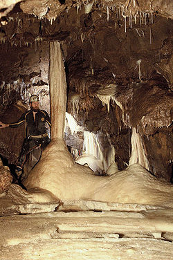
Stoke Lane Slocker Stoke Lane Slocker is 2.18 km in length and reaches a depth of 30m. It was previously known as Stoke Lane Swallet, but now the local name is preferred. The origin of the word “Slocker” is obscure.
Dinies Camp Dinies Camp is a univallate Iron Age hill fort enclosure in Mendip district of Somerset. The hill fort is situated approximately 1 mile (1.6 km) south-west from the village of Downhead.
St. Dunstan’s Well Catchment St Dunstan’s Well Catchment (grid reference ST668475) is a Site of Special Scientific Interest. Formerly known as Stoke St Michael Slocker, it contains nine SSSI units. The site was notified in 1967.
Church of St Michael, Stoke St Michael The Anglican Church of St Michael in Stoke St Michael, Somerset, was built around 1400. It is a Grade II* listed building.
Shatter Cave Shatter Cave is a cave in Fairy Cave Quarry, near Stoke St Michael in the limestone of the Mendip Hills, in Somerset. It falls within the St. Dunstan’s Well Catchment Site of Special Scientific Interest.
Torr Works Torr Works quarry, grid reference ST695446 is a limestone quarry at East Cranmore, near Shepton Mallet, Somerset. The quarry was formerly known as Merehead, a name which has been retained for its rail depot on the opposite side of the A361 road.
Mells Village Hall Mells Village Hall in Mells, Somerset, was built in the 14th century as a tithe barn. It is a Grade II* listed building and is now the village hall.
Mells Manor Mells Manor at Mells, Somerset, was built in the 16th century for Edward Horner. The house, along with the garden walls, has been designated as a Grade I listed building. The gardens are listed, Grade I, on the Register of Historic Parks and Gardens of special historic interest.
Mells Park Mells Park is a country estate of 140 hectares (350 acres) near Mells, Somerset. It originated as a 17th-century deer park, probably created by the Horner family. It contains Park House, a Grade II* listed building, built in 1925 in neoclassical style by the architect Edwin Lutyens.
St James’ Church, East Cranmore St James’ Church is a former Church of England church in East Cranmore, Somerset. It was built in 1846 to replace an earlier church on the same site and closed in 1958. The church is a Grade II listed building.
Visit Leigh-on-Mendip plaques
0 plaques hereLeigh-on-Mendip has 0 physical plaques in tourist plaque schemes for you to explore via Walkfo Leigh-on-Mendip plaques audio map when visiting. Plaques like National Heritage’s “Blue Plaques” provide visual geo-markers to highlight points-of-interest at the places where they happened – and Walkfo’s AI has researched additional, deeper content when you visit Leigh-on-Mendip using the app. Experience the history of a location when Walkfo local tourist guide app triggers audio close to each Leigh-on-Mendip plaque. Currently No Physical Plaques.
Experience Leigh-on-Mendip audio walks & tours
Walkfo guides for things to do / places to visit in Leigh-on-Mendip allows exploration as you would do an art gallery or museum. Walk close to one of Leigh-on-Mendip’s 41 historic places & our digital tour guide will create an audio story for that spot. With headphone connected, you can explore Leigh-on-Mendip freely by foot, bike or bus – with your own personal tour guide in your pocket.
Explore Leigh-on-Mendip Map App
Our visit Leigh-on-Mendip map shows you things-to-do & places you can visit in Leigh-on-Mendip & surrounding areas using the Walkfo digital audio tour guide app. Each spot has plaque, building, street or area information on history, culture or tourism.
You can set your Walkfo’s Leigh-on-Mendip tourist map to find historic & tourism spots within 1km, 3km & 5km of the Leigh-on-Mendip centre, depending on how far you plan to explore whilst you visit Leigh-on-Mendip area at LONG:-2.4374, LAT:51.2263.
Walkfo App
Walkfo
Walkfo is free to download & use (for a limited time period), so if you are looking to explore Leigh-on-Mendip, go to your App Store to search for “Walkfo” or follow a links below and install on your mobile phone. Walkfo is designed for use with headphones or AirPods, so you can walk & explore whilst learning about the things around you without digital distraction.
Things to do & visit in Leigh-on-Mendip / surrounding areas
● Colemans Quarry ● Holwell Quarries ● Cloford Quarry ● Church of St George, Whatley ● Manor Farmhouse Gatehouse, Whatley ● Whatley, Mendip ● Whatley Quarry ● Leigh-on-Mendip ● Halecombe ● Church of All Saints, Downhead ● Downhead ● Stoke Lane Slocker ● Dinies Camp ● St. Dunstan’s Well Catchment ● Cook’s Wood Quarry ● Stoke St Michael ● Church of St Michael, Stoke St Michael ● Coleford, Somerset ● Moon’s Hill Quarry ● Edford Woods and Meadows ● Asham Wood ● Holcombe, Somerset ● Cranmore Tower ● W/L Cave ● Fairy Cave Quarry ● Shatter Cave ● Balch Cave ● Hillier’s Cave ● Torr Works ● Babington, Somerset
● Babington House ● Mells, Somerset ● Mells Village Hall ● Mells War Memorial ● St Andrew’s Church, Mells ● Equestrian statue of Edward Horner ● Mells Manor ● Mells Park ● St James’ Church, East Cranmore
Getting to / around Leigh-on-Mendip – transport link, station & street map
Getting around in Leigh-on-Mendip using public transportation may include road, street, train, underground, bus or tram transport options. Walkfo has identified the following Leigh-on-Mendip places with historic / cultural / factual content when you visit:
Local Leigh-on-Mendip historians & Leigh-on-Mendip tour guides
Trying to encourage visitors to Leigh-on-Mendip? Walkfo has millions audio places already available but Walkfo Creator gives Leigh-on-Mendip’s places, attractions & landmarks ability to create their own unique outdoor audio museums & using our simple & easy to use Walkfo Creator. – Creating a new audio experience for your Leigh-on-Mendip place is free* and quick (15+ minutes if you prepare text content) to use, with Walkfo Creator doing the hard work of generating AI audio files for geo-spots from the text you provide with a simply click on a map. – The 100 Amazing Leigh-on-Mendip Places is just one example of an outdoor museum created using Walkfo Creator (pictured to the left) for people to safely explore during Covid-19 times whilst visiting a city. Our tool is open to tourism organisations, travel destinations & National Trust locations to create their own audio walks to offer free when people visit Leigh-on-Mendip destinations. – Walkfo itself is looking to partner with websites offering things-to-do / what’s on events listings to enhance the content of our ‘visit-Leigh-on-Mendip’ web pages (for example: www.visitLeigh-on-Mendip.com). If you are interested in partnering, please contact us to discuss options.
* Walkfo Creator is free to use for a limited number of audio spots within a map with a license fee applicable when more than 20 audio spots within location walk are created. v1.1336
 Visit Leigh-on-Mendip places using Walkfo for free guided tours of the best Leigh-on-Mendip places to visit. A unique way to experience Leigh-on-Mendip’s places, Walkfo allows you to explore Leigh-on-Mendip as you would a museum or art gallery with audio guides.
 You can visit Leigh-on-Mendip places with Walkfo Leigh-on-Mendip to hear history at Leigh-on-Mendip’s places whilst walking around using the free digital tour app. Walkfo Leigh-on-Mendip has 41 places to visit in our interactive Leigh-on-Mendip map, with amazing history, culture & travel facts you can explore the same way you would at a museum or art gallery with information audio headset. With Walkfo, you can travel by foot, bike or bus throughout Leigh-on-Mendip, being in the moment, without digital distraction or limits to a specific walking route. Our historic audio walks, National Trust interactive audio experiences, digital tour guides for English Heritage locations are available at Leigh-on-Mendip places, with a AI tour guide to help you get the best from a visit to Leigh-on-Mendip & the surrounding areas.


 0
0


 Trying to encourage visitors to Leigh-on-Mendip?