Welcome to Visit Leigh, Kent Places
The Walkfo guide to things to do & explore in Leigh, Kent
 Visit Leigh, Kent places using Walkfo for free guided tours of the best Leigh, Kent places to visit. A unique way to experience Leigh, Kent’s places, Walkfo allows you to explore Leigh, Kent as you would a museum or art gallery with audio guides.
Visiting Leigh, Kent Walkfo Preview
Leigh is located six miles (10 km) south of Sevenoaks town and three miles (5 km) west of Tonbridge. There is a large village green; nearby is Hall Place, once Leigh Hall, occasionally open to the public, built in 1876. When you visit Leigh, Kent, Walkfo brings Leigh, Kent places to life as you travel by foot, bike, bus or car with a mobile phone & headphones.
Leigh, Kent Places Overview: History, Culture & Facts about Leigh, Kent
Visit Leigh, Kent – Walkfo’s stats for the places to visit
With 26 audio plaques & Leigh, Kent places for you to explore in the Leigh, Kent area, Walkfo is the world’s largest heritage & history digital plaque provider. The AI continually learns & refines facts about the best Leigh, Kent places to visit from travel & tourism authorities (like Wikipedia), converting history into an interactive audio experience.
Leigh, Kent history
Leigh is thought to have grown from a hamlet, evidence of which dates back to the 11th century. The name of the village derives from the Old English leah, meaning a forest glade or clearing. The village grew substantially in the 19th century when the Baily and Morley families built many of the distinctive buildings present today.
Why visit Leigh, Kent with Walkfo Travel Guide App?
 You can visit Leigh, Kent places with Walkfo Leigh, Kent to hear history at Leigh, Kent’s places whilst walking around using the free digital tour app. Walkfo Leigh, Kent has 26 places to visit in our interactive Leigh, Kent map, with amazing history, culture & travel facts you can explore the same way you would at a museum or art gallery with information audio headset. With Walkfo, you can travel by foot, bike or bus throughout Leigh, Kent, being in the moment, without digital distraction or limits to a specific walking route. Our historic audio walks, National Trust interactive audio experiences, digital tour guides for English Heritage locations are available at Leigh, Kent places, with a AI tour guide to help you get the best from a visit to Leigh, Kent & the surrounding areas.
“Curated content for millions of locations across the UK, with 26 audio facts unique to Leigh, Kent places in an interactive Leigh, Kent map you can explore.”
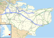
Walkfo: Visit Leigh, Kent Places Map
26 tourist, history, culture & geography spots
Leigh, Kent historic spots | Leigh, Kent tourist destinations | Leigh, Kent plaques | Leigh, Kent geographic features |
| Walkfo Leigh, Kent tourism map key: places to see & visit like National Trust sites, Blue Plaques, English Heritage locations & top tourist destinations in Leigh, Kent | |||
Best Leigh, Kent places to visit
Leigh, Kent has places to explore by foot, bike or bus. Below are a selection of the varied Leigh, Kent’s destinations you can visit with additional content available at the Walkfo Leigh, Kent’s information audio spots:
 | Bidborough Windmill Bidborough Mill is a Grade II listed, house converted tower mill west of Bidborough, Kent. It is now incorporated into a housing development called Mill Court. |
 | River Eden, Kent River Eden is a tributary of the River Medway in south east England. It rises at the foot of the North Downs escarpment near Titsey in Surrey. The name ‘Eden’ is a back-formation from Edenbridge, (Eadhelmsbrigge) in Old English. |
 | Penshurst Park Penshurst Park Cricket Ground, also known as Earl of Leicester’s Park, is a cricket ground at Penshurst in Kent. It is one of the oldest cricket venues in England and hosted its first recorded match in 1724. |
 | Oast Theatre, Tonbridge The Oast Theatre is based in an old oast house in Tonbridge, Kent. It is home to the Tonbridge Theatre and Arts Club. The theatre seats 112 people. |
 | Corn Exchange, Tonbridge The Corn Exchange is a former chapel, trading facility and military installation at Bank Street in Tonbridge, Kent. It was a former military installation and trading facility at the Corn Exchange. |
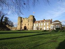 | Tonbridge Castle Tonbridge Castle is situated in Tonbridge, Kent, England. The castle is located in the town of Tonbridge in the middle of Kent. |
 | Lullingstone Country Park Lullingstone Country Park is a former deer park of a large estate. It was later sold to become an open-space and woodland park. The park is a biological Site of Special Scientific Interest Kent. |
 | Haysden Country Park Haysden Country Park is a 64-hectare (160-acre) country park and Local Nature Reserve. It is owned by Tonbridge and Malling Borough Council, the Highways Agency, Network Rail and the Environment Agency. |
 | Penshurst railway station Penshurst railway station is located two miles north of Penshurst in Kent, in the village of Chiddingstone Causeway in England. It is 38 miles 3 chains (61.22 km) measured from London Charing Cross via Redhill. |
 | St John the Baptist, Penshurst St John the Baptist Church at Penshurst, Kent is a Grade I listed Anglican parish church in the Diocese of Rochester. Those buried or commemorated here include Knights, Earls, Viscounts, a Viceroy of India, a Governor-General of Australia, a Private Secretary to two Kings, two Field Marshals and two winners of the Victoria Cross. |
Visit Leigh, Kent plaques
 4
4
plaques
here Leigh, Kent has 4 physical plaques in tourist plaque schemes for you to explore via Walkfo Leigh, Kent plaques audio map when visiting. Plaques like National Heritage’s “Blue Plaques” provide visual geo-markers to highlight points-of-interest at the places where they happened – and Walkfo’s AI has researched additional, deeper content when you visit Leigh, Kent using the app. Experience the history of a location when Walkfo local tourist guide app triggers audio close to each Leigh, Kent plaque. Explore Plaques & History has a complete list of Hartlepool’s plaques & Hartlepool history plaque map.


 Trying to encourage visitors to Leigh, Kent?