Welcome to Visit Leigh, Greater Manchester Places
The Walkfo guide to things to do & explore in Leigh, Greater Manchester
 Visit Leigh, Greater Manchester places using Walkfo for free guided tours of the best Leigh, Greater Manchester places to visit. A unique way to experience Leigh, Greater Manchester’s places, Walkfo allows you to explore Leigh, Greater Manchester as you would a museum or art gallery with audio guides.
Visiting Leigh, Greater Manchester Walkfo Preview
When you visit Leigh, Greater Manchester, Walkfo brings Leigh, Greater Manchester places to life as you travel by foot, bike, bus or car with a mobile phone & headphones.
Leigh, Greater Manchester Places Overview: History, Culture & Facts about Leigh, Greater Manchester
Visit Leigh, Greater Manchester – Walkfo’s stats for the places to visit
With 60 audio plaques & Leigh, Greater Manchester places for you to explore in the Leigh, Greater Manchester area, Walkfo is the world’s largest heritage & history digital plaque provider. The AI continually learns & refines facts about the best Leigh, Greater Manchester places to visit from travel & tourism authorities (like Wikipedia), converting history into an interactive audio experience.
Leigh, Greater Manchester history
Toponymy
Leigh is derived from the Old English leah which meant a place at the wood or woodland clearing, a glade and subsequently a pasture or meadow . Legh was spelt Legh in 1276, Leech, 1264; Leeche, 1268; Leghthe, 1305, Leght, 1417; Lech, 1451 and Legh, 16th century . Westleigh, the west clearing, was Westeley in 1237, Westlegh and Westlay in 1292 .
Early history
The earliest signs of human activity in Leigh are evidenced by a Neolithic stone axe and a bronze spearhead from south of Gas Street . A single Roman coin was found at Butts in Bedford .
Townships
In the 12th century the ancient parish of Leigh was made up of six townships . Weekly markets were held by the parish church and a cattle fair held twice-yearly .
Civil War
Leigh was divided in its allegiance during the English Civil War . Some of the population supported the Royalists’ cause while others supported the Parliamentarians . A battle was fought in the town on 2 December 1642, when a group of Chowbenters beat back .
Industrial Revolution
Work was supplied from Manchester by agents who brought work weekly to an inn . At first the work was done to supplement the income of local farmers and their families . The cloth woven in Leigh was fustian, a sort of rough corduroy .
Coal mining

Parsonage Colliery, the last pit to be sunk in Leigh, was one of the deepest in the country, going down to over 3,000 ft (900 m) The entire Lancashire Coalfield is closed to deep mining, although several open-cast mines are still in operation elsewhere in the county .
Manufacturing
Mansley’s Rope works on Twist Lane made rope by hand, using a rope walk . Anchor Cables had a large works close to the Bridgewater Canal . Another major 20th century employer was Sutcliffe Speakman, which made activated carbon and brick-making equipment .
Leigh, Greater Manchester culture & places
Many of Leigh’s old halls have been demolished but the sites of Lilford Park, once the grounds of Atherton Hall, are open to the public. Lilford was a gift to Leigh from Lord Lilford in 1914.
Leigh, Greater Manchester landmarks
Major landmarks in Leigh are the red sandstone parish church and across the civic square, Leigh Town Hall and its associated shops on Market Street. The Grade II listed Obelisk that replaced the original market cross is also situated here.
Leigh, Greater Manchester geography / climate
Astley and Bedford Mosses are fragments of the raised bog that once covered a large area north of the River Mersey. Land to the south and east, close to Chat Moss, is 50 feet (15 m) above mean sea level. Magnesian limestone occurs in Bedford and neighbouring Astley.
Why visit Leigh, Greater Manchester with Walkfo Travel Guide App?
 You can visit Leigh, Greater Manchester places with Walkfo Leigh, Greater Manchester to hear history at Leigh, Greater Manchester’s places whilst walking around using the free digital tour app. Walkfo Leigh, Greater Manchester has 60 places to visit in our interactive Leigh, Greater Manchester map, with amazing history, culture & travel facts you can explore the same way you would at a museum or art gallery with information audio headset. With Walkfo, you can travel by foot, bike or bus throughout Leigh, Greater Manchester, being in the moment, without digital distraction or limits to a specific walking route. Our historic audio walks, National Trust interactive audio experiences, digital tour guides for English Heritage locations are available at Leigh, Greater Manchester places, with a AI tour guide to help you get the best from a visit to Leigh, Greater Manchester & the surrounding areas.
“Curated content for millions of locations across the UK, with 60 audio facts unique to Leigh, Greater Manchester places in an interactive Leigh, Greater Manchester map you can explore.”
Walkfo: Visit Leigh, Greater Manchester Places Map
60 tourist, history, culture & geography spots
Leigh, Greater Manchester historic spots | Leigh, Greater Manchester tourist destinations | Leigh, Greater Manchester plaques | Leigh, Greater Manchester geographic features |
| Walkfo Leigh, Greater Manchester tourism map key: places to see & visit like National Trust sites, Blue Plaques, English Heritage locations & top tourist destinations in Leigh, Greater Manchester | |||
Best Leigh, Greater Manchester places to visit
Leigh, Greater Manchester has places to explore by foot, bike or bus. Below are a selection of the varied Leigh, Greater Manchester’s destinations you can visit with additional content available at the Walkfo Leigh, Greater Manchester’s information audio spots:
| Parsonage Colliery Parsonage Colliery was a coal mine operating on the Lancashire Coalfield . It was sunk between 1913 and 1920 by the Wigan Coal and Iron Company . For many years its shafts to the Arley mine were the deepest in the country . |
 | Mather Lane Mill Mather Lane Mills was a complex of cotton mills built by the Bridgewater Canal in Bedford, Leigh in Lancashire . The No 2 mill and its former warehouse are grade II listed buildings . |
 | Pennington Flash Country Park Pennington Flash Country Park is a 200-hectare (490-acre) country park located between Lowton and Leigh in Greater Manchester . |
 | Howe Bridge Colliery Howe Bridge Colliery was part of Fletcher, Burrows and Company’s collieries at Howe Bridge in Atherton, Greater Manchester, then in the historic county of Lancashire . |
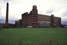
 | Leigh Spinners Leigh Spinners or Leigh Mill is a Grade II* listed double cotton spinning mill in Bedford, Leigh, Greater Manchester . The mill was built in the 1930s . |
 | Damhouse Damhouse or Astley Hall is a Grade II* Listed building in Astley, Greater Manchester. It has served as a manor house, sanatorium and sanatorium. Since restoration in 2000, it houses offices, a clinic, nursery and tearooms. |
 | St Stephen’s Church, Astley St Stephen’s Church is an active Anglican church in Astley, Greater Manchester. It was built in 1968 and part of Leigh deanery in the archdeaconry of Salford and diocese of Manchester. |
 | Higher Folds Higher Folds is 10 miles from Manchester in the unparished area of Leigh, in the Wigan district. In 2018 it had an estimated population of 2,770. Shaun Keaveny grew up in the town and grew up there. |
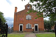 | Tyldesley Top Chapel Top Chapel was built in 1789 on a site of 1,300 square yards at the top of Tyldesley Banks opposite the Square. The site and building materials were all provided by Thomas Johnson. It was properly known as “The Lady Huntingdon Chapel” but became known as Top Chapel because of its position. |
 | Tyldesley Urban District Tyldesley cum Shakerley Urban District was, from 1894 to 1974, a local government district in Lancashire, England. |
Visit Leigh, Greater Manchester plaques
 0
0
plaques
here Leigh, Greater Manchester has 0 physical plaques in tourist plaque schemes for you to explore via Walkfo Leigh, Greater Manchester plaques audio map when visiting. Plaques like National Heritage’s “Blue Plaques” provide visual geo-markers to highlight points-of-interest at the places where they happened – and Walkfo’s AI has researched additional, deeper content when you visit Leigh, Greater Manchester using the app. Experience the history of a location when Walkfo local tourist guide app triggers audio close to each Leigh, Greater Manchester plaque. Currently No Physical Plaques.


 Trying to encourage visitors to Leigh, Greater Manchester?