Welcome to Visit Lambourne Places
The Walkfo guide to things to do & explore in Lambourne
 Visit Lambourne places using Walkfo for free guided tours of the best Lambourne places to visit. A unique way to experience Lambourne’s places, Walkfo allows you to explore Lambourne as you would a museum or art gallery with audio guides.
Visiting Lambourne Walkfo Preview
Lambourne is a civil parish in the Epping Forest district of Essex. It is located approximately 4.5 miles (7 km) South of Epping and 5 miles (8 km) northwest of Romford. It covers an area of 2,590 acres (1,050 ha) and in 2001 its population was 1,828. When you visit Lambourne, Walkfo brings Lambourne places to life as you travel by foot, bike, bus or car with a mobile phone & headphones.
Lambourne Places Overview: History, Culture & Facts about Lambourne
Visit Lambourne – Walkfo’s stats for the places to visit
With 19 audio plaques & Lambourne places for you to explore in the Lambourne area, Walkfo is the world’s largest heritage & history digital plaque provider. The AI continually learns & refines facts about the best Lambourne places to visit from travel & tourism authorities (like Wikipedia), converting history into an interactive audio experience.
Lambourne history
Lambourne was thickly wooded in the Middle Ages with forest gradually being cleared for agriculture. A few remnants of the historic Hainault Forest are found in the southern fringe of the parish, and now form part of a country park.
Lambourne landmarks
The medieval parish church of St Mary is in an isolated location next to the Hall, as is typical for Essex. It has an unusual Georgian internal remodelling. Lieutenant Colonel Amelius Lockwood, 1st Baron Lambourne, is buried in the churchyard.
Lambourne geography / climate
There is no actual village called Lambourne, the principal settlement is the village of Abridge in the far northwest of the parish. The parish is mostly rural and agricultural, and lies in the valley of the River Roding.
Why visit Lambourne with Walkfo Travel Guide App?
 You can visit Lambourne places with Walkfo Lambourne to hear history at Lambourne’s places whilst walking around using the free digital tour app. Walkfo Lambourne has 19 places to visit in our interactive Lambourne map, with amazing history, culture & travel facts you can explore the same way you would at a museum or art gallery with information audio headset. With Walkfo, you can travel by foot, bike or bus throughout Lambourne, being in the moment, without digital distraction or limits to a specific walking route. Our historic audio walks, National Trust interactive audio experiences, digital tour guides for English Heritage locations are available at Lambourne places, with a AI tour guide to help you get the best from a visit to Lambourne & the surrounding areas.
“Curated content for millions of locations across the UK, with 19 audio facts unique to Lambourne places in an interactive Lambourne map you can explore.”
Walkfo: Visit Lambourne Places Map
19 tourist, history, culture & geography spots
Lambourne historic spots | Lambourne tourist destinations | Lambourne plaques | Lambourne geographic features |
| Walkfo Lambourne tourism map key: places to see & visit like National Trust sites, Blue Plaques, English Heritage locations & top tourist destinations in Lambourne | |||
Best Lambourne places to visit
Lambourne has places to explore by foot, bike or bus. Below are a selection of the varied Lambourne’s destinations you can visit with additional content available at the Walkfo Lambourne’s information audio spots:

Loughton Hall
The architect was William Eden Nesfield, and it is grade II listed with Historic England . It is now a 33-bedroom residential care home for elderly people .

Hainault Forest
Hainault Forest Country Park is a Country Park located in Greater London . It is located in the London Borough of Redbridge, Havering and Havering . It also includes portions in the Lambourne parish of the Epping Forest District in Essex .
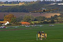
Stapleford Aerodrome
Stapleford Aerodrome (ICAO: EGSG) is an operational general aviation aerodrome in the Epping Forest district of Essex, England. It is about 3.4 nautical miles (6.3 km; 3.9 mi) south of North Weald Airfield. The airfield is just within the M25, close to the junction with the M11.
Visit Lambourne plaques
 1
1
plaques
here Lambourne has 1 physical plaques in tourist plaque schemes for you to explore via Walkfo Lambourne plaques audio map when visiting. Plaques like National Heritage’s “Blue Plaques” provide visual geo-markers to highlight points-of-interest at the places where they happened – and Walkfo’s AI has researched additional, deeper content when you visit Lambourne using the app. Experience the history of a location when Walkfo local tourist guide app triggers audio close to each Lambourne plaque. Explore Plaques & History has a complete list of Hartlepool’s plaques & Hartlepool history plaque map.


 Trying to encourage visitors to Lambourne?