Welcome to Visit Knapton, North Yorkshire Places The Walkfo guide to things to do & explore in Knapton, North Yorkshire
Visit Knapton, North Yorkshire places using Walkfo for free guided tours of the best Knapton, North Yorkshire places to visit. A unique way to experience Knapton, North Yorkshire’s places, Walkfo allows you to explore Knapton, North Yorkshire as you would a museum or art gallery with audio guides.
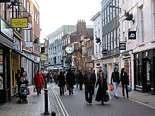
Visiting Knapton, North Yorkshire Walkfo Preview Knapton is 3 miles west of York in the City of York unitary authority and ceremonial county of North Yorkshire. It is bounded by the village of Acomb to the east, the B1224 to the south, the A59 to the north and the A1237 York Outer Ring Road to the west. When you visit Knapton, North Yorkshire, Walkfo brings Knapton, North Yorkshire places to life as you travel by foot, bike, bus or car with a mobile phone & headphones.
Knapton, North Yorkshire Places Overview: History, Culture & Facts about Knapton, North Yorkshire
Visit Knapton, North Yorkshire – Walkfo’s stats for the places to visit
With 96 audio plaques & Knapton, North Yorkshire places for you to explore in the Knapton, North Yorkshire area, Walkfo is the world’s largest heritage & history digital plaque provider. The AI continually learns & refines facts about the best Knapton, North Yorkshire places to visit from travel & tourism authorities (like Wikipedia), converting history into an interactive audio experience.
Knapton, North Yorkshire history
In 1843 the village had a population of 113 in an area of approximately 883 acres made up mainly of farmhouses. In the sixteenth century, the village was a detached part of the parish of Holy Trinity, Micklegate in York. In 1974 the parish was transferred from the West Riding of Yorkshire (which included the Ainsty of York) to the Harrogate district in the new county of North Yorkshire.
Why visit Knapton, North Yorkshire with Walkfo Travel Guide App?
You can visit Knapton, North Yorkshire places with Walkfo Knapton, North Yorkshire to hear history at Knapton, North Yorkshire’s places whilst walking around using the free digital tour app. Walkfo Knapton, North Yorkshire has 96 places to visit in our interactive Knapton, North Yorkshire map, with amazing history, culture & travel facts you can explore the same way you would at a museum or art gallery with information audio headset. With Walkfo, you can travel by foot, bike or bus throughout Knapton, North Yorkshire, being in the moment, without digital distraction or limits to a specific walking route. Our historic audio walks, National Trust interactive audio experiences, digital tour guides for English Heritage locations are available at Knapton, North Yorkshire places, with a AI tour guide to help you get the best from a visit to Knapton, North Yorkshire & the surrounding areas.
“Curated content for millions of locations across the UK, with 96 audio facts unique to Knapton, North Yorkshire places in an interactive Knapton, North Yorkshire map you can explore.”
Walkfo Knapton, North Yorkshire tourism map key: places to see & visit like National Trust sites, Blue Plaques, English Heritage locations & top tourist destinations in Knapton, North Yorkshire
Best Knapton, North Yorkshire places to visit
Knapton, North Yorkshire has places to explore by foot, bike or bus. Below are a selection of the varied Knapton, North Yorkshire’s destinations you can visit with additional content available at the Walkfo Knapton, North Yorkshire’s information audio spots:
Woodthorpe, North Yorkshire The name Woodthorpe is generally used for the areas south of Acomb Wood and east to Moorcroft Road and Acorn Way. To the east is Dringhouses, to the north is Foxwood, and to the west is Acomb Park. In January 2017 Katie Rough was killed by asphyxiation and stabbed in the neck near her home by a 15-year-old female.
Dringhouses Dringhouses is a suburb, formerly a village, in York, England. It is bounded by the Knavesmire, an open area of land on which York Racecourse is situated, to the east, Askham Bog and the A64 to the south, Woodthorpe and Foxwood to the west, and Acomb and Holgate to the north. The name derives from “Drengeshirses” and means “the houses of the drengs”
Wandesford House Wandesford House is one of twelve still-functioning almshouses in York, England. Built in 1739 and opened in 1743, the house is an important example of the classical style in the city. The almshouse is listed by Historic England as a Grade II* building.
Duncombe Place Duncombe Place is a street in the city centre of York, in England. Duncombe Street is one of the streets in the centre of the city.
Museum Street (York) Museum Street is a road in the city centre of York, in England. It is one of the main roads in York and is located in the centre of the city.
Coney Street Coney Street runs north-west from Spurriergate and Market Street to St Helen’s Square. Several snickelways lead from the south-west side down to the River Ouse.
Grand Hotel and Spa (York) The Grand Hotel and Spa is a Grade II* listed hotel in York, England. Opened in May 2010, it is the city’s only 5-star hotel. It was originally the headquarters of the North Eastern Railway.
Jacobs Well, York Jacobs Well is a mediaeval Grade I listed building in the Micklegate area of York, England. It is the church hall of Holy Trinity, Micklegate.
Clifton Hospital Clifton Hospital was a mental health facility in York, England. It was established in the 1930s. It is now owned by a private company.
Rufforth Circuit Rufforth Circuit was built on the site of a World War II bomber base, RAF Rufforth, opened in 1942. The airfield remained in active service after the war, eventually closing in 1954. The circuit hosted Formula 2 and Formula Junior races between 1961-1978.
Visit Knapton, North Yorkshire plaques
68 plaques hereKnapton, North Yorkshire has 68 physical plaques in tourist plaque schemes for you to explore via Walkfo Knapton, North Yorkshire plaques audio map when visiting. Plaques like National Heritage’s “Blue Plaques” provide visual geo-markers to highlight points-of-interest at the places where they happened – and Walkfo’s AI has researched additional, deeper content when you visit Knapton, North Yorkshire using the app. Experience the history of a location when Walkfo local tourist guide app triggers audio close to each Knapton, North Yorkshire plaque. Explore Plaques & History has a complete list of Hartlepool’s plaques & Hartlepool history plaque map.
Experience Knapton, North Yorkshire audio walks & tours
Walkfo guides for things to do / places to visit in Knapton, North Yorkshire allows exploration as you would do an art gallery or museum. Walk close to one of Knapton, North Yorkshire’s 96 historic places & our digital tour guide will create an audio story for that spot. With headphone connected, you can explore Knapton, North Yorkshire freely by foot, bike or bus – with your own personal tour guide in your pocket.
Explore Knapton, North Yorkshire Map App
Our visit Knapton, North Yorkshire map shows you things-to-do & places you can visit in Knapton, North Yorkshire & surrounding areas using the Walkfo digital audio tour guide app. Each spot has plaque, building, street or area information on history, culture or tourism.
You can set your Walkfo’s Knapton, North Yorkshire tourist map to find historic & tourism spots within 1km, 3km & 5km of the Knapton, North Yorkshire centre, depending on how far you plan to explore whilst you visit Knapton, North Yorkshire area at LONG:-1.144956, LAT:53.960308.
Walkfo App
Walkfo
Walkfo is free to download & use (for a limited time period), so if you are looking to explore Knapton, North Yorkshire, go to your App Store to search for “Walkfo” or follow a links below and install on your mobile phone. Walkfo is designed for use with headphones or AirPods, so you can walk & explore whilst learning about the things around you without digital distraction.
Things to do & visit in Knapton, North Yorkshire / surrounding areas
● Woodthorpe, North Yorkshire ● Dringhouses ● Acomb, North Yorkshire ● Gateway Church, York ● Knapton, North Yorkshire ● Dringhouses Yard ● York Cold War Bunker ● Askham Bryan ● Rural West York ● Holgate Windmill ● Goddards House and Garden ● Holgate, North Yorkshire ● Institute of Physics and Engineering in Medicine ● Knavesmire ● Holy Redeemer Church, York ● York Racecourse ● Bootham ● Bootham Crescent ● Bootham Park Hospital ● Ingram House ● BBC Radio York ● Clifton Without ● Wandesford House ● York Art Gallery ● Exhibition Square ● Clifton Park Ground ● Marygate ● King’s Manor ● Department of Archaeology, University of York ● Archaeology Data Service
● St Olave’s Church, York ● St Leonard’s Place ● St Lawrence’s Church, York ● York Theatre Royal ● Anglian Tower ● Duncombe Place ● St Mary’s Abbey, York ● York Museum Gardens ● York Oratory ● York Library ● York Assembly Rooms ● Judges’ Lodgings, York ● Lendal ● Augustinian Friary, York ● St Helen’s Square ● York City War Memorial ● Mansion House, York ● York Guildhall ● St Martin le Grand, York ● York Clifton Carriage Sidings ● RAF Clifton ● The Principal York ● Grand Hotel and Spa (York) ● National Railway Museum ● North Eastern Railway War Memorial ● St John’s Church, Micklegate, York ● Micklegate ● York IECC ● St Martin-cum-Gregory’s Church, Micklegate, York ● Holy Trinity Church, Micklegate, York ● Jacobs Well, York ● 85–89 Micklegate ● Rawcliffe, York ● Micklegate Priory ● Bishophill ● Henry VII Experience at Micklegate Bar ● St Mary Bishophill Junior, York ● Clifton Hospital ● York Rail Operating Centre ● Bar Convent ● Nether Poppleton Tithebarn ● Nether Poppleton ● Upper Poppleton ● Overton, North Yorkshire ● Rufforth ● Rufforth Circuit ● RAF Rufforth ● Clifton, York ● Ivory Bangle Lady ● Yorkshire Museum ● Lendal Tower ● Overton Hoard ● Tanner Row ● Micklegate House ● Micklegate ● Holgate Beck ● York Central (development) ● Garforth House ● St Stephen’s Church, Acomb ● St Everilda’s Church, Nether Poppleton ● Petergate House ● The Red House (York) ● St Nicholas’ Church, Askham Bryan ● Bathurst House
Getting to / around Knapton, North Yorkshire – transport link, station & street map
Getting around in Knapton, North Yorkshire using public transportation may include road, street, train, underground, bus or tram transport options. Walkfo has identified the following Knapton, North Yorkshire places with historic / cultural / factual content when you visit:
Local Knapton, North Yorkshire Public Transport Stations
Knapton, North Yorkshire Notable Streets & Road Destinations
York railway station (1841)
York railway station
Poppleton railway station
York Racecourse railway station
Museum Street (York)
Blake Street (York)
York Leeman Road depot
Coney Street
All Saints’ Church, North Street, York
North Street (York)
Blossom Street
Holgate Road carriage works, York
Wesley Chapel, Priory Street
[transportsummary]
Local Knapton, North Yorkshire historians & Knapton, North Yorkshire tour guides
Trying to encourage visitors to Knapton, North Yorkshire? Walkfo has millions audio places already available but Walkfo Creator gives Knapton, North Yorkshire’s places, attractions & landmarks ability to create their own unique outdoor audio museums & using our simple & easy to use Walkfo Creator. – Creating a new audio experience for your Knapton, North Yorkshire place is free* and quick (15+ minutes if you prepare text content) to use, with Walkfo Creator doing the hard work of generating AI audio files for geo-spots from the text you provide with a simply click on a map. – The 100 Amazing Knapton, North Yorkshire Places is just one example of an outdoor museum created using Walkfo Creator (pictured to the left) for people to safely explore during Covid-19 times whilst visiting a city. Our tool is open to tourism organisations, travel destinations & National Trust locations to create their own audio walks to offer free when people visit Knapton, North Yorkshire destinations. – Walkfo itself is looking to partner with websites offering things-to-do / what’s on events listings to enhance the content of our ‘visit-Knapton, North Yorkshire’ web pages (for example: www.visitKnapton, North Yorkshire.com). If you are interested in partnering, please contact us to discuss options.
* Walkfo Creator is free to use for a limited number of audio spots within a map with a license fee applicable when more than 20 audio spots within location walk are created. v1.1336
 Visit Knapton, North Yorkshire places using Walkfo for free guided tours of the best Knapton, North Yorkshire places to visit. A unique way to experience Knapton, North Yorkshire’s places, Walkfo allows you to explore Knapton, North Yorkshire as you would a museum or art gallery with audio guides.
 You can visit Knapton, North Yorkshire places with Walkfo Knapton, North Yorkshire to hear history at Knapton, North Yorkshire’s places whilst walking around using the free digital tour app. Walkfo Knapton, North Yorkshire has 96 places to visit in our interactive Knapton, North Yorkshire map, with amazing history, culture & travel facts you can explore the same way you would at a museum or art gallery with information audio headset. With Walkfo, you can travel by foot, bike or bus throughout Knapton, North Yorkshire, being in the moment, without digital distraction or limits to a specific walking route. Our historic audio walks, National Trust interactive audio experiences, digital tour guides for English Heritage locations are available at Knapton, North Yorkshire places, with a AI tour guide to help you get the best from a visit to Knapton, North Yorkshire & the surrounding areas.


 68
68


 Trying to encourage visitors to Knapton, North Yorkshire?