Welcome to Visit Kirkthorpe Places
The Walkfo guide to things to do & explore in Kirkthorpe
 Visit Kirkthorpe places using Walkfo for free guided tours of the best Kirkthorpe places to visit. A unique way to experience Kirkthorpe’s places, Walkfo allows you to explore Kirkthorpe as you would a museum or art gallery with audio guides.
Visiting Kirkthorpe Walkfo Preview
Kirkthorpe is a village within the City of Wakefield metropolitan borough of West Yorkshire. It lies 3 miles (4.8 km) east of the city centre. When you visit Kirkthorpe, Walkfo brings Kirkthorpe places to life as you travel by foot, bike, bus or car with a mobile phone & headphones.
Kirkthorpe Places Overview: History, Culture & Facts about Kirkthorpe
Visit Kirkthorpe – Walkfo’s stats for the places to visit
With 46 audio plaques & Kirkthorpe places for you to explore in the Kirkthorpe area, Walkfo is the world’s largest heritage & history digital plaque provider. The AI continually learns & refines facts about the best Kirkthorpe places to visit from travel & tourism authorities (like Wikipedia), converting history into an interactive audio experience.
Kirkthorpe history
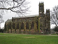
Kirkthorpe is one of the villages on the proposed route north to Leeds of HS2. The village has an Anglican church, the Church of St Peter, which was built in the 14th century and rebuilt in 1875.
Kirkthorpe toponymy
The name “Kirkthorpe” means “outlying or secondary hamlet or farmstead with a church” It is formed of two elements, the Old English throp or the Old Scandinavian thorp.
Why visit Kirkthorpe with Walkfo Travel Guide App?
 You can visit Kirkthorpe places with Walkfo Kirkthorpe to hear history at Kirkthorpe’s places whilst walking around using the free digital tour app. Walkfo Kirkthorpe has 46 places to visit in our interactive Kirkthorpe map, with amazing history, culture & travel facts you can explore the same way you would at a museum or art gallery with information audio headset. With Walkfo, you can travel by foot, bike or bus throughout Kirkthorpe, being in the moment, without digital distraction or limits to a specific walking route. Our historic audio walks, National Trust interactive audio experiences, digital tour guides for English Heritage locations are available at Kirkthorpe places, with a AI tour guide to help you get the best from a visit to Kirkthorpe & the surrounding areas.
“Curated content for millions of locations across the UK, with 46 audio facts unique to Kirkthorpe places in an interactive Kirkthorpe map you can explore.”
Walkfo: Visit Kirkthorpe Places Map
46 tourist, history, culture & geography spots
Kirkthorpe historic spots | Kirkthorpe tourist destinations | Kirkthorpe plaques | Kirkthorpe geographic features |
| Walkfo Kirkthorpe tourism map key: places to see & visit like National Trust sites, Blue Plaques, English Heritage locations & top tourist destinations in Kirkthorpe | |||
Best Kirkthorpe places to visit
Kirkthorpe has places to explore by foot, bike or bus. Below are a selection of the varied Kirkthorpe’s destinations you can visit with additional content available at the Walkfo Kirkthorpe’s information audio spots:
 | St Peter’s Church, Stanley, West Yorkshire St Peter’s Church in Stanley, Wakefield, West Yorkshire, was a Church of England church. The church opened in 1824, closed in 2001 and after falling into disrepair was demolished in 2014. |
 | Wakefield Museum Wakefield Museum is a local museum in Wakefield, West Yorkshire, north England. It covers the history of the city of Wakefield and the local area from prehistoric times onwards. |
 | City of Wakefield The population of the City of Wakefield at the 2011 Census was 325,837. Wakefield is the district’s administrative centre. The district includes the Five Towns, Normanton, Pontefract, Featherstone, Castleford and Knottingley. |
 | Chantry Chapel of St Mary the Virgin, Wakefield The Chantry Chapel of St Mary the Virgin, Wakefield, is a Grade I Listed building. It is located south of the city centre on the medieval bridge over the River Calder. The chapel is the oldest and most ornate of the surviving bridge chapels in England. |
 | Normanton (electoral ward) Normanton is an electoral ward of the City of Wakefield district. It is used for elections to Wakefield Metropolitan District Council elections. Normanton electoral ward is part of the Wakefield District Council. |
| Crofton, West Yorkshire Crofton is about 4 miles (6 km) south-east of Wakefield, some 6 miles (10 km) to the west of the town of Pontefract. The population of the civil parish at the 2011 census was 5,781. |
 | Heath Hall, Heath, West Yorkshire Heath Hall, Heath, Wakefield, West Yorkshire is a Grade I listed country house. Originally called Eshald House, the estate was purchased by John Smyth. His nephew engaged John Carr of York to reconstruct the house between 1754 and 1780. |
 | Fieldhead Hospital Fieldhead Hospital is a psychiatric and learning disability hospital in Wakefield, England. It is managed by South West Yorkshire Partnership NHS Foundation Trust. |
 | Normanton, West Yorkshire Normanton is a town north-east of Wakefield and south-west of Castleford. At the time of the 2011 Census, the population of the civil parish was 20,872. The Normanton ward of the Wakefield City Council had a population of 16,220. |
Visit Kirkthorpe plaques
 37
37
plaques
here Kirkthorpe has 37 physical plaques in tourist plaque schemes for you to explore via Walkfo Kirkthorpe plaques audio map when visiting. Plaques like National Heritage’s “Blue Plaques” provide visual geo-markers to highlight points-of-interest at the places where they happened – and Walkfo’s AI has researched additional, deeper content when you visit Kirkthorpe using the app. Experience the history of a location when Walkfo local tourist guide app triggers audio close to each Kirkthorpe plaque. Explore Plaques & History has a complete list of Hartlepool’s plaques & Hartlepool history plaque map.


 Trying to encourage visitors to Kirkthorpe?