Visit Kinross-shire – things to do & explore
 When you visit Kinross-shire on a day-trip, weekend away or holiday, Walkfo is the digital tour guide to the hidden history & cultural facts that you can explore in Kinross-shire. Millions of audio content spots are available when you travel by foot, bike, bus or car around Kinross-shire through your mobile phone connected to headphones.
Overview of Kinross-shire history & facts by Walkfo

Planning a visit to Kinross-shire?
The County of Kinross or Kinross-shire is a historic county and registration county in eastern Scotland, administered as part of Perth and Kinross since 1930. Surrounding its largest settlement and county town of Kinross, the county borders Perthshire to the north and Fife to the east, south and west. Scotland’s second smallest county, Kinross-shire is dominated by Loch Leven, a large inland loch, with two islands and an internationally important nature reserve. One of the islands contains a castle, where Mary, Queen of Scots was once held prisoner. Much of the land in Kinross-shire is fertile agricultural land and most of the inhabitants were originally employed in farming. The gently-rolling farmland surrounding Loch Leven gives way to steep, more rugged terrain at the outskirts of the county.
Kinross-shire history
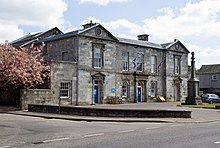
The shire or sheriffdom of Kinross was formed in the thirteenth century when the two parishes of Kinross and Orwell were removed from the Fothriff area of Fife. Cleish, Portmoak and Tullibole were added by act of parliament in 1685. As local government in Scotland evolved, Kinross-shire gained a county council in 1890, which was later amalgamated with Perth County Council under the Local Government (Scotland) Act 1929. Kinross County Council was based at County Buildings, High Street, Kinross. The county suffered a decline in population in the 19th and 20th centuries, as its inhabitants migrated to the cities to find work in manufacturing, etc. The population in 1891 was 6,673; in 1971 it was 6,423. The decline was hastened by the closure of the railways in the county soon after the Second World War. However, in recent years, construction of the M90 motorway north of the Forth Road Bridge has resulted in the area becoming more prominent. Tourism has increased, with visitors attracted by the unspoiled country villages and gently rolling hills reaching the shores of Loch Leven. The villages of Kinnesswood and Scotlandwell are attractive, and there are ancient standing stones at Orwell. The T in the Park music festival was held in Balado from 1993 – 2014. The economic outlook of Kinross-shire has improved and was recorded in 2009 as having an estimated population of 12,997. In addition, it outperformed both the Perth and Kinross area and Scotland averages in economic performance. The area is promoted by the Kinross-shire Partnership, a body bringing together local government, tourist organisations and local organisations.
Kinross-shire geography / climate

Kinross-shire is landlocked and is generally flat, except in the north-west where the Ochil Hills are located, and along the southern boundary where the Cleish Hills can be found. The Ochils contain Innerdouny Hill, Kinross-shire’s highest point at 497 m (1,631 ft). The most notable geographic feature of the county is Loch Leven which is also an important nature reserve; there are also several islands within the loch, the largest of which is St Serf’s Inch (the others are Alice’s Bower, Castle Island, Reed Bower, Roy’s Folly and Scart Island). A much smaller body of water – the Arnot Reservoir – is located to the east of Loch Leven. On the far northern border a portion of the Glenfarg Reservoir lies within the county.
You can visit Kinross-shire, COUNTY/BOROUGH & use Walkfo to discover the best walking places with our free digital tour guide app created especially for Kinross-shire. Walkfo Kinross-shire has 300 locations with history, culture & travel facts, that you can explore the same way you can a museum or art gallery with information audio headset. With Walkfo, you can travel by foot, bike or bus throughout Kinross-shire, being in the moment, without digital distraction and no limitations to a specific walking route – you choose where you want to go, when you want to go and Walkfo Kinross-shire will keep up.
When you visit Kinross-shire
When you visit Kinross-shire, Walkfo is your digital tour guide while exploring by foot, bike or bus. With numerous walks, hikes, tourist locations & travel destinations available in Kinross-shire, our travel AI guide helps you get the best from your visit to Kinross-shire & the surrounding areas. Our explore Kinross-shire app for iPhone & Android, allows you to experience the hidden history, culture and amazing facts throughout Kinross-shire whilst out walking. The digital tour guide creates interactive audio stories driven by where you walk, so you can exploration Kinross-shire’s National Heritage sites, tourist attractions, historic locations or city streets freely, without the restrictions of a predefined walk & walk map.
“The Walkfo AI has curated content for millions of locations across the UK, with 0 audio facts in Kinross-shire alone that form an interactive Kinross-shire walking map for you to explore.”
Best Kinross-shire places to visit
Kinross-shire has hundreds of places to explore by foot, bike or bus. Below are five of Kinross-shire’s best destinations to visit when exploring the area. We have condensed the information with much more detail available within Walkfo when you visit the destinations.
bVisit Kinross-shire plaques

 Kinross-shire has 0 plaques as part of nation or local tourist plaque schemes for you to explore when you visit. Plaque schemes such as National Heritage’s “Blue Plaques” provide a visual geo marker to highlight points of interest things, at the places where they happened. Walkfo has researched each plaque to provide additional content when you visit the Kinross-shire plaques whilst using the app. Experience the hidden history & stories behind each location as the Walkfo local tourist guide app uses GPS to trigger audio close to each Kinross-shire plaque. Walkfo also offers millions of additional ‘virtual geo plaques’ that are unique to Walkfo, created across the UK (and the world).
When using Walkfo to explore Kinross-shire, you will hear the full story of each of these plaques.
Experience Kinross-shire audio walks & tours
Walkfo is a free app that shows you things to do / visit in Kinross-shire on a map. You can explore the area as you wish, as you would do an art gallery or museum, and when you walk close to those locations, our digital tour guide will tell you history, culture & travel facts about the location in audio form. With headphone connected, you can explore Kinross-shire freely by foot, bike or bus – with your own personal tour guide in your pocket.
Visiting Kinross-shire with Walkfo’s things to do interactive map
The “Kinross-shire things to do map” below is a preview of the places you can visit in Kinross-shire and surrounding areas with our digital audio tour guide app. Each spot has content for a plaque, a building, a street or general area, providing history, culture or tourism information the you can explore.
| Interactive ‘Explore Kinross-shire Map’
This Kinross-shire tourism map shows points of interest within a 4km radius of Kinross-shire centre | Walkfo App
Walkfo   |

Walkfo is free to download & use (for a limited time period), so if you are looking to explore Kinross-shire, go to your App Store to search for “Walkfo” or follow a links below and install on your mobile phone. Walkfo is designed for use with headphones or AirPods, so you can walk & explore whilst learning about the things around you without digital distraction.
Apple App Store
Google Play Store
Things to do & visit in Kinross-shire and surrounding areas
Getting to / around Kinross-shire – transport links, stations, streets & traffic map
Getting around in Kinross-shire using public transportation may include roads, streets, trains, undergrounds, buses or trams. Walkfo has the following important Kinross-shire public transport locations with historic / cultural / factual content when you visit:
| Kinross-shire Notable Public Transport Stations | Kinross-shire Notable Streets & Roads | |
|---|---|---|
| | |
[transportsummary]
Attention local Kinross-shire historians, tour guides & Kinross-shire tourism agents
 Looking for a way to get more visitors to Kinross-shire?
Whilst Walkfo has millions audio spots already available, Walkfo Creator allows tourist destinations, attractions & landmarks to create their own unique outdoor audio museums & walks using the simple & easy to use Walkfo Creator. Creating an audio walk for you destination is free* and can be created in under 15 minutes if you have content ready, with Walkfo Creator doing all the hard work generating audio files for geo spot you simply click on a map.
The 100 Amazing Kinross-shire Places outdoor museum was created using Walkfo Creator (pictured to the left) as a way for people to safely explore the area during Covid-19 times whilst improving the experience of visiting a city when tourism boards use Walkfo to market their destination.
Walkfo is currently looking to partner with websites who offer things-to-do / what’s on events listings to add to our content on our webpages (for example: www.visitKinross-shire.com). If you are interested in being a content provider, please contact us to discuss options.
* Walkfo Creator is free to use for a limited number of audio spots within a map with a license fee applicable when more than 20 audio spots within location walk are created.