Welcome to Visit Kimmeridge Places
The Walkfo guide to things to do & explore in Kimmeridge
 Visit Kimmeridge places using Walkfo for free guided tours of the best Kimmeridge places to visit. A unique way to experience Kimmeridge’s places, Walkfo allows you to explore Kimmeridge as you would a museum or art gallery with audio guides.
Visiting Kimmeridge Walkfo Preview
When you visit Kimmeridge, Walkfo brings Kimmeridge places to life as you travel by foot, bike, bus or car with a mobile phone & headphones.
Kimmeridge Places Overview: History, Culture & Facts about Kimmeridge
Visit Kimmeridge – Walkfo’s stats for the places to visit
With 34 audio plaques & Kimmeridge places for you to explore in the Kimmeridge area, Walkfo is the world’s largest heritage & history digital plaque provider. The AI continually learns & refines facts about the best Kimmeridge places to visit from travel & tourism authorities (like Wikipedia), converting history into an interactive audio experience.
Kimmeridge history
In the Iron Age and during the Roman occupation, ornaments and other objects were made from the black bituminous shale, known as blackstone or ‘Kimmeridge coal’ The Romans also used the shale as fuel for boiling sea water to produce salt. Armlets were manufactured from the shale using a lathe, which produced waste in the form of hard black discs.
Kimmeridge geography / climate
Kimmeridge civil parish is 7 miles west of Swanage, 4.5 miles (7.2 km) south of Wareham and 15 miles (24 km) east of Weymouth. It is sited beside a small stream on a roughly southwest-facing slope between the English Channel coast and a line of hills.
Geology
The bedrock is mostly Kimmeridge clay, except for the top of Smedmore Hill and along to Swyre Head, which is formed from Portland stone . Landslip deposits from the Portland stone cover the steep southwest-facing slopes of the hills .
Why visit Kimmeridge with Walkfo Travel Guide App?
 You can visit Kimmeridge places with Walkfo Kimmeridge to hear history at Kimmeridge’s places whilst walking around using the free digital tour app. Walkfo Kimmeridge has 34 places to visit in our interactive Kimmeridge map, with amazing history, culture & travel facts you can explore the same way you would at a museum or art gallery with information audio headset. With Walkfo, you can travel by foot, bike or bus throughout Kimmeridge, being in the moment, without digital distraction or limits to a specific walking route. Our historic audio walks, National Trust interactive audio experiences, digital tour guides for English Heritage locations are available at Kimmeridge places, with a AI tour guide to help you get the best from a visit to Kimmeridge & the surrounding areas.
“Curated content for millions of locations across the UK, with 34 audio facts unique to Kimmeridge places in an interactive Kimmeridge map you can explore.”
Walkfo: Visit Kimmeridge Places Map
34 tourist, history, culture & geography spots
Kimmeridge historic spots | Kimmeridge tourist destinations | Kimmeridge plaques | Kimmeridge geographic features |
| Walkfo Kimmeridge tourism map key: places to see & visit like National Trust sites, Blue Plaques, English Heritage locations & top tourist destinations in Kimmeridge | |||
Best Kimmeridge places to visit
Kimmeridge has places to explore by foot, bike or bus. Below are a selection of the varied Kimmeridge’s destinations you can visit with additional content available at the Walkfo Kimmeridge’s information audio spots:

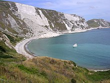
Kimmeridge Oil Field
Kimmeridge Oil Field is on the south coast of the Isle of Purbeck, in Dorset, England . The field is located to the northwest of the Kimmeridge Bay, on the Island Purbeck, south of the Dorset coast .

The Etches Collection
The Etches Collection is an independent fossil museum based in the village of Kimmeridge, Purbeck, Dorset . It is based on the lifetime collection of Steve Etches, a fossil hunter for whom some of his finds have been named .

Smedmore House
Smedmore House was originally built by Sir William Clavell around 1620 . It is not normally open to the public, although there are regular open days . English Heritage have designated it a Grade II* listed building .
Purbeck Hills
The Purbeck Hills, also called the Purbeck Ridge or simply the Purbecks, are a ridge of chalk downs in Dorset, England . The hills are part of a system of chalk downlands in southern England formed from the Chalk Group .

Gad Cliff
Gad Cliff is a south-facing cliff face on the south coast of the Isle of Purbeck in Dorset . Behind it is Gold Down, part of the Lulworth Ranges .

Encombe House
Encombe House is a Grade II* listed country house built in 1735 on the Encombe Estate near the village of Kingston in Dorset. It is 1-mile inland of Dorset’s Jurassic Coast in southern England. The parkland is Grade II listed in the National Register of Historic Parks and Gardens.
Visit Kimmeridge plaques
 0
0
plaques
here Kimmeridge has 0 physical plaques in tourist plaque schemes for you to explore via Walkfo Kimmeridge plaques audio map when visiting. Plaques like National Heritage’s “Blue Plaques” provide visual geo-markers to highlight points-of-interest at the places where they happened – and Walkfo’s AI has researched additional, deeper content when you visit Kimmeridge using the app. Experience the history of a location when Walkfo local tourist guide app triggers audio close to each Kimmeridge plaque. Currently No Physical Plaques.


 Trying to encourage visitors to Kimmeridge?