Welcome to Visit Ingatestone Places
The Walkfo guide to things to do & explore in Ingatestone
 Visit Ingatestone places using Walkfo for free guided tours of the best Ingatestone places to visit. A unique way to experience Ingatestone’s places, Walkfo allows you to explore Ingatestone as you would a museum or art gallery with audio guides.
Visiting Ingatestone Walkfo Preview
Ingatestone lies in the Metropolitan Green Belt 20 miles (32 km) north-east of London. It has become an affluent commuter village, seen as one of the UK’s best places to live. When you visit Ingatestone, Walkfo brings Ingatestone places to life as you travel by foot, bike, bus or car with a mobile phone & headphones.
Ingatestone Places Overview: History, Culture & Facts about Ingatestone
Visit Ingatestone – Walkfo’s stats for the places to visit
With 18 audio plaques & Ingatestone places for you to explore in the Ingatestone area, Walkfo is the world’s largest heritage & history digital plaque provider. The AI continually learns & refines facts about the best Ingatestone places to visit from travel & tourism authorities (like Wikipedia), converting history into an interactive audio experience.
Ingatestone history

Ingatestone appeared in Saxon times on the Essex Great Road (now the A12) between the Roman towns of Londinium (London) and Camulodunum (Colchester) The name means “Ing at the Stone”, the suffix distinguishing it from nearby settlements that also formed part of the manor of Ing.
Why visit Ingatestone with Walkfo Travel Guide App?
 You can visit Ingatestone places with Walkfo Ingatestone to hear history at Ingatestone’s places whilst walking around using the free digital tour app. Walkfo Ingatestone has 18 places to visit in our interactive Ingatestone map, with amazing history, culture & travel facts you can explore the same way you would at a museum or art gallery with information audio headset. With Walkfo, you can travel by foot, bike or bus throughout Ingatestone, being in the moment, without digital distraction or limits to a specific walking route. Our historic audio walks, National Trust interactive audio experiences, digital tour guides for English Heritage locations are available at Ingatestone places, with a AI tour guide to help you get the best from a visit to Ingatestone & the surrounding areas.
“Curated content for millions of locations across the UK, with 18 audio facts unique to Ingatestone places in an interactive Ingatestone map you can explore.”
Walkfo: Visit Ingatestone Places Map
18 tourist, history, culture & geography spots
Ingatestone historic spots | Ingatestone tourist destinations | Ingatestone plaques | Ingatestone geographic features |
| Walkfo Ingatestone tourism map key: places to see & visit like National Trust sites, Blue Plaques, English Heritage locations & top tourist destinations in Ingatestone | |||
Best Ingatestone places to visit
Ingatestone has places to explore by foot, bike or bus. Below are a selection of the varied Ingatestone’s destinations you can visit with additional content available at the Walkfo Ingatestone’s information audio spots:
 | Mountnessing Windmill Mountnessing Windmill is a grade II* listed post mill in Essex. Built in 1807, it was most recently restored to working order in 1983. |
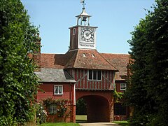 | Ingatestone Hall Ingatestone Hall is a Grade I listed 16th-century manor house in Essex. It was built by Sir William Petre and his descendants live in the house to this day. Part of the house is leased out as offices while the current Lord Petre’s son and heir apparent lives in a private wing with his family. |
| Ingatestone and Fryerning The parish includes the villages of Ingatestone and Fryerning, and covers an area of 3,917 acres (15.85 km) The parish is in the Brentwood borough of Essex. |
 | Fryerning Mill Fryerning Mill (or Mill Green Mill) is a grade II* listed post mill at Mill Green, Fryerning, Essex, which has been restored. |
 | St Mary’s Buttsbury St Mary’s is a Grade II* listed parish church in the village of Buttsbury, Essex. It is located 1.5 miles (2.4 km) north west of Ingatestone and 3.8 miles (6.1 km) south east of Billericay. The site is believed to have been where St Botolph preached under a pear tree. |
Visit Ingatestone plaques
 0
0
plaques
here Ingatestone has 0 physical plaques in tourist plaque schemes for you to explore via Walkfo Ingatestone plaques audio map when visiting. Plaques like National Heritage’s “Blue Plaques” provide visual geo-markers to highlight points-of-interest at the places where they happened – and Walkfo’s AI has researched additional, deeper content when you visit Ingatestone using the app. Experience the history of a location when Walkfo local tourist guide app triggers audio close to each Ingatestone plaque. Currently No Physical Plaques.


 Trying to encourage visitors to Ingatestone?