Welcome to Visit Handbridge Places
The Walkfo guide to things to do & explore in Handbridge
 Visit Handbridge places using Walkfo for free guided tours of the best Handbridge places to visit. A unique way to experience Handbridge’s places, Walkfo allows you to explore Handbridge as you would a museum or art gallery with audio guides.
Visiting Handbridge Walkfo Preview
Handbridge is a district of Chester, England on the south bank of the River Dee. A settlement has existed on the site since the Iron Age, but the site saw major expansion during the collapse of the Roman occupation of Britain. The site was originally mainly a quarry for the abundant red sandstone that much Chester is built from. When you visit Handbridge, Walkfo brings Handbridge places to life as you travel by foot, bike, bus or car with a mobile phone & headphones.
Handbridge Places Overview: History, Culture & Facts about Handbridge
Visit Handbridge – Walkfo’s stats for the places to visit
With 200 audio plaques & Handbridge places for you to explore in the Handbridge area, Walkfo is the world’s largest heritage & history digital plaque provider. The AI continually learns & refines facts about the best Handbridge places to visit from travel & tourism authorities (like Wikipedia), converting history into an interactive audio experience.
Handbridge history
Roman era
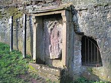
Handbridge is built on a large sandstone outcrop which was used to construct the city walls and buildings. The quarry was also the site of a small shrine to the goddess Minerva which is still visible in what is known as Edgar’s Field.
Post-Roman
By the time of the Domesday Book, the site had grown large enough to be divided into three manors: Overleigh, Netherleigh and Royal Handbridge. Little is known of Handbridge from this time, as Chester was repeatedly attacked by Viking raiders.
Middle Ages

The Welsh name for Handbridge is Treboeth, meaning either “the hot town” or “the burnt town” The current Old Dee Bridge dates from 1353, but at least four other bridges existed on the site beforehand. Chester Weir across the river was built in 1093, under the orders of Hugh Lupus, to provide power to water powered mills along the banks of the river.
English Civil War
During the English Civil War, Chester was one of the last Royalist strongholds, and as such was heavily besieged. Handbridge was burnt once again and the bridge heavily damaged to impede the progress of the Roundhead armies. This forced the Parliamentarians to cross the river at a ford ten miles (16 km) upstream.
Victorian era
Handbridge, Chester, was a poor suburb of the Dee River. The population were primarily industrial workers who worked in the factories that surrounded the area. The Grosvenor Bridge was the largest single-span bridge in the world for 30 years until 1864.
20th century
Handbridge continued to grow in the 20th century with several large schools and a college being built. Among the buildings built were the “Salmon Leap” flats, designed by Gilling Dod and Partners and constructed in 1967/68. On the riverside is a small cottage named “Nowhere”, believed to have originally been a secret tavern.
Why visit Handbridge with Walkfo Travel Guide App?
 You can visit Handbridge places with Walkfo Handbridge to hear history at Handbridge’s places whilst walking around using the free digital tour app. Walkfo Handbridge has 200 places to visit in our interactive Handbridge map, with amazing history, culture & travel facts you can explore the same way you would at a museum or art gallery with information audio headset. With Walkfo, you can travel by foot, bike or bus throughout Handbridge, being in the moment, without digital distraction or limits to a specific walking route. Our historic audio walks, National Trust interactive audio experiences, digital tour guides for English Heritage locations are available at Handbridge places, with a AI tour guide to help you get the best from a visit to Handbridge & the surrounding areas.
“Curated content for millions of locations across the UK, with 200 audio facts unique to Handbridge places in an interactive Handbridge map you can explore.”
Walkfo: Visit Handbridge Places Map
200 tourist, history, culture & geography spots
Handbridge historic spots | Handbridge tourist destinations | Handbridge plaques | Handbridge geographic features |
| Walkfo Handbridge tourism map key: places to see & visit like National Trust sites, Blue Plaques, English Heritage locations & top tourist destinations in Handbridge | |||
Best Handbridge places to visit
Handbridge has places to explore by foot, bike or bus. Below are a selection of the varied Handbridge’s destinations you can visit with additional content available at the Walkfo Handbridge’s information audio spots:

Countess of Chester Country Park
The Countess of Chester Country Park is a country park in Upton, Chester, Cheshire, England. It is named after the adjacent County of Chester Hospital.

Chester Golf Club
Chester Golf Club is located in Curzon Park, Chester, Cheshire. The 18-hole parkland course is contained within a loop of the River Dee. The clubhouse has a licensed bar.

Newtown, Chester
Newtown is an area of Chester, in the unitary authority of Cheshire West and Chester and the ceremonial county of Chester. Newtown is one of the areas in the area of the Cheshire boroughs of Chester and Chester.

Old Bank Buildings, Chester
Old Bank Buildings is row of shops and offices in Foregate Street in Chester. It is located in the centre of Foregate St, Chester, on the banks side of the river.

County Hall, Chester
County Hall is a former municipal building on Castle Drive in Chester, Cheshire, England. It was the headquarters of Cheshire County Council and is now the Riverside campus of the University of Chester.
Chester Crown Court
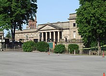
Chester Crown Court is a judicial facility at Castle Square in Chester, Cheshire. The Grade I listed building forms part of a series of imposing buildings at Chester Castle.

Equestrian statue of Viscount Combermere
Equestrian Statue of Viscount Combermere stands on an island in Grosvenor Road, Chester, Cheshire. It commemorates his successful military career, and was made by Carlo Marochetti. It is recorded in the National Heritage List for England as a designated Grade II* listed building.

Chester Raft Race
The Chester Raft Race is an annual charity event taking place every July on the River Dee in Chester. The rafts race against the clock over a quarter mile (400 m) course, starting by the rowing club, and passing under pedestrian suspension bridge.
Chester (district)
Chester was a non-metropolitan local government district of Cheshire from 1974 to 2009. It had the status of a city and a borough. Apart from Chester itself, the district covered a large rural area.

Curzon Park Abbey
Curzon Park Abbey is one of three monasteries of nuns in the English Benedictine Congregation. The Abbey is a Benedictine monastery of nuns.
Visit Handbridge plaques
 40
40
plaques
here Handbridge has 40 physical plaques in tourist plaque schemes for you to explore via Walkfo Handbridge plaques audio map when visiting. Plaques like National Heritage’s “Blue Plaques” provide visual geo-markers to highlight points-of-interest at the places where they happened – and Walkfo’s AI has researched additional, deeper content when you visit Handbridge using the app. Experience the history of a location when Walkfo local tourist guide app triggers audio close to each Handbridge plaque. Explore Plaques & History has a complete list of Hartlepool’s plaques & Hartlepool history plaque map.


 Trying to encourage visitors to Handbridge?