Welcome to Visit Hackney, London Places
The Walkfo guide to things to do & explore in Hackney, London
 Visit Hackney, London places using Walkfo for free guided tours of the best Hackney, London places to visit. A unique way to experience Hackney, London’s places, Walkfo allows you to explore Hackney, London as you would a museum or art gallery with audio guides.
Visiting Hackney, London Walkfo Preview
Hackney is 4 miles (6.4 km) northeast of Charing Cross and includes part of the Queen Elizabeth Olympic Park. Historically it was within the county of Middlesex. In the past it was also referred to as Hackney Proper to distinguish it from the village which developed in the vicinity of Mare Street. When you visit Hackney, London, Walkfo brings Hackney, London places to life as you travel by foot, bike, bus or car with a mobile phone & headphones.
Hackney, London Places Overview: History, Culture & Facts about Hackney, London
Visit Hackney, London – Walkfo’s stats for the places to visit
With 933 audio plaques & Hackney, London places for you to explore in the Hackney, London area, Walkfo is the world’s largest heritage & history digital plaque provider. The AI continually learns & refines facts about the best Hackney, London places to visit from travel & tourism authorities (like Wikipedia), converting history into an interactive audio experience.
Hackney, London history
Pre-Roman
Hackney is a mostly low-lying area in proximity to two rivers, the Lea and Hackney Brook. This would have made the area attractive for pastoral and arable agriculture. There is archaeological evidence for settlement and agriculture as far back as Stone Age.
Roman
There will have been a network of probably minor, local roads in Hackney before the Romans conquered southern Britain after 43AD. The area’s proximity to the provincial capital, Londinium, meant that it was soon crossed by two large long-distance routes. The first was Ermine Street (modern A10) which emerged from Bishopsgate and headed north to Lincoln and York. The second was a route which branched off Ermine and headed SW-NE across Hackney, across the Dalston, Hackney Central and Lower Clapton areas.
Anglo-Saxon
Aescwine, having rebelled against Octa, King of Kent, defeats him in battle and became the (reputed) first King of Essex. The place name Hackney is Old English, so was probably first applied in this era. Hackney was part of the territory of the Middle Saxons, a people who formed a province of the East Saxons.
The Norman Conquest
Hackney is only assessed as part of the Manor of Stepney, of which it was a sub-manor. Domesday returns for Middlesex indicate that it was around 30% wooded, about double the English average. Hackney would have had a lower proportion than the county as a whole.
Post-medieval
From the Tudor period onwards, the various settlements in Hackney grew as wealthy Londoners moved to what they saw as a pleasant rural alternative to living in London. A number of royal courtiers lived in Homerton, while Henry VIII had a palace at Brooke House, Upper Clapton.
Urbanisation
The main ‘Hackney Village’ grew much larger than the others, in 1605 having as many houses as Dalston, Newington (ie West Hackney), Kingsland and Shacklewell combined. In the 1770s Hackney became home to one of the largest and most celebrated plant nurseries in England, Loddiges Paradise Field Nursery.
Edwardian
In 1907, the Fifth Congress of the Russian Social Democratic Labour Party held at the Brotherhood Church on the east side of Southgate Road. Attendees included Lenin, Stalin, Maxim Gorky, Rosa Luxemburg and Leon Trotsky.
World War One
The first bomb of the first air raid on London, fell on 16 Alkham Road, West Hackney in May 1915 by the German Army airship LZ 38. No one was seriously hurt at that address but the raid killed seven people elsewhere, including four children, causing great anger among the public. East London was at particular risk at this time, due to the Kaiser’s order, later rescinded, that the raiders limit their attacks to targets east of the Tower of London. Hackney raised two front-line infantry battalions for the London Regiment.
Blitz
Hackney was badly affected by wartime bombing that left the area with 749 civilian war dead. Many other Hackney residents were also killed on active service around the world. Notable buildings destroyed by bombing included Tudor-era Brooke House in Upper Clapton.
Post-war and Olympic Games
During the 1930s, 1940s and 1960s the area’s large Jewish and other minority populations made it a target for provocative rallies by Oswald Mosley and far-right organisations he founded. The post-war period saw extensive re-building, and the area became increasingly multi-cultural in character. Hackney was one of the host areas when London staged the 2012 Olympic and Paralympic Games.
Affordable housing
Hackney built a significant number of affordable units and subsidised them with market-rate units. In Hackney about half of the new units are affordable. In an effort to avoid displacing current residents, construction was completed in phases.
Hackney, London geography / climate
The outline of Hackney’s traditional boundary resembles a right-angled triangle with the right-angle in the SW and the Lower Lea Valley, running NW-SE forming the hypotenuse. The western boundary is based on the N-S axis of the Roman A10, though the sub-district of De Beauvoir Town lies beyond it. The highest points around Stamford Hill and Clapton Common are over 30m AOD, with the lowest areas being along the River Lea.
Why visit Hackney, London with Walkfo Travel Guide App?
 You can visit Hackney, London places with Walkfo Hackney, London to hear history at Hackney, London’s places whilst walking around using the free digital tour app. Walkfo Hackney, London has 933 places to visit in our interactive Hackney, London map, with amazing history, culture & travel facts you can explore the same way you would at a museum or art gallery with information audio headset. With Walkfo, you can travel by foot, bike or bus throughout Hackney, London, being in the moment, without digital distraction or limits to a specific walking route. Our historic audio walks, National Trust interactive audio experiences, digital tour guides for English Heritage locations are available at Hackney, London places, with a AI tour guide to help you get the best from a visit to Hackney, London & the surrounding areas.
“Curated content for millions of locations across the UK, with 933 audio facts unique to Hackney, London places in an interactive Hackney, London map you can explore.”
Walkfo: Visit Hackney, London Places Map
933 tourist, history, culture & geography spots
Hackney, London historic spots | Hackney, London tourist destinations | Hackney, London plaques | Hackney, London geographic features |
| Walkfo Hackney, London tourism map key: places to see & visit like National Trust sites, Blue Plaques, English Heritage locations & top tourist destinations in Hackney, London | |||
Best Hackney, London places to visit
Hackney, London has places to explore by foot, bike or bus. Below are a selection of the varied Hackney, London’s destinations you can visit with additional content available at the Walkfo Hackney, London’s information audio spots:
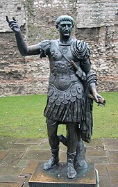 | Statue of Trajan, Tower Hill The statue of Trajan is a bronze sculpture depicting the Roman Emperor Trajan. It is located in front of a section of the London Wall built by Romans, at Tower Hill in London. |
 | Knollys Rose Ceremony The Knollys Rose Ceremony is an annual event led by the Company of Watermen and Lightermen . The ceremony dates to 1381 and is held each year in June . A single red rose is snipped from the garden in Seething Lane, placed on an altar cushion from All Hallows-by-the-Tower . |
 | Seething Lane Seething Lane is named after an Old English expression meaning “full of chaff” Samuel Pepys lived there and is buried in St Olave’s Church at the junction with Hart Street . |
 | East India Arms The East India Arms is located on Fenchurch Street in the City of London . It is next to the place where the East India Company had its headquarters . |
 | Bull and Mouth Street Bull and Mouth Street was a street in the City of London that ran between Edward Street (Hall Lane) and St Martin’s Le Grand . On part of its site stands Postman’s Park . |
 | Memorial to Heroic Self-Sacrifice The Memorial to Heroic Self-Sacrifice is a public monument in Postman’s Park in the City of London . It was first proposed by painter and sculptor George Frederic Watts in 1887, to commemorate the Golden Jubilee of Queen Victoria . The memorial was unveiled in an unfinished state in 1900, consisting of a 50-foot (15 m) wooden loggia designed by Ernest George . |
 | St. Martin’s Le Grand St. Martin’s Le Grand is a former liberty within the City of London . It is the name of a street north of Newgate Street and Cheapside and south of Aldersgate Street . |
 | Swan with Two Necks, London The Swan with Two Necks was a coaching inn in the City of London . It was one of the principal departure points for travel to the north of England from London . Site was given over in the early 1860s to a goods and parcels depot for a firm of railway agents and carriers . |
 | Blossom’s Inn Blossom’s Inn was a tavern which stood in Lawrence Lane in the City of London from the 14th century until 1855 . It became a substantial coaching inn and was used as a staging post by carriers of goods . In the 19th century, the lease was bought and it became the parcel depot of the Great Eastern Railway . |
 | Guildhall Library The Guildhall Library is a public reference library specialising in subjects relevant to London . It is administered by the Corporation of London, the government of the City of London . |
Visit Hackney, London plaques
 295
295
plaques
here Hackney, London has 295 physical plaques in tourist plaque schemes for you to explore via Walkfo Hackney, London plaques audio map when visiting. Plaques like National Heritage’s “Blue Plaques” provide visual geo-markers to highlight points-of-interest at the places where they happened – and Walkfo’s AI has researched additional, deeper content when you visit Hackney, London using the app. Experience the history of a location when Walkfo local tourist guide app triggers audio close to each Hackney, London plaque. Explore Plaques & History has a complete list of Hartlepool’s plaques & Hartlepool history plaque map.


 Trying to encourage visitors to Hackney, London?