Welcome to Visit Grasmere (village) Places
The Walkfo guide to things to do & explore in Grasmere (village)
 Visit Grasmere (village) places using Walkfo for free guided tours of the best Grasmere (village) places to visit. A unique way to experience Grasmere (village)’s places, Walkfo allows you to explore Grasmere (village) as you would a museum or art gallery with audio guides.
Visiting Grasmere (village) Walkfo Preview
William and Dorothy Wordsworth lived in Grasmere for 14 years and called it “the loveliest spot that man hath ever found” In 1961, the civil parish had a population of 1,029. When you visit Grasmere (village), Walkfo brings Grasmere (village) places to life as you travel by foot, bike, bus or car with a mobile phone & headphones.
Grasmere (village) Places Overview: History, Culture & Facts about Grasmere (village)
Visit Grasmere (village) – Walkfo’s stats for the places to visit
With 41 audio plaques & Grasmere (village) places for you to explore in the Grasmere (village) area, Walkfo is the world’s largest heritage & history digital plaque provider. The AI continually learns & refines facts about the best Grasmere (village) places to visit from travel & tourism authorities (like Wikipedia), converting history into an interactive audio experience.
Grasmere (village) etymology
Early spellings with “Grys-” or “Gris(s)-” might suggest Old Norse “griss”, meaning “young pig” Evidence points to Old English/Old Norse “gres”, meaning grass, with modern form influenced by Standard English.
Grasmere (village) geography / climate
Helm Crag is popularly known as The Lion and the Lamb or The Old Lady at the Piano. The village is on the River Rothay, which flows into Grasmere lake about 0.5 km to the south. The main A591 road connects the Vale of Keswick over Dunmail Raise to the north and to Ambleside.
Why visit Grasmere (village) with Walkfo Travel Guide App?
 You can visit Grasmere (village) places with Walkfo Grasmere (village) to hear history at Grasmere (village)’s places whilst walking around using the free digital tour app. Walkfo Grasmere (village) has 41 places to visit in our interactive Grasmere (village) map, with amazing history, culture & travel facts you can explore the same way you would at a museum or art gallery with information audio headset. With Walkfo, you can travel by foot, bike or bus throughout Grasmere (village), being in the moment, without digital distraction or limits to a specific walking route. Our historic audio walks, National Trust interactive audio experiences, digital tour guides for English Heritage locations are available at Grasmere (village) places, with a AI tour guide to help you get the best from a visit to Grasmere (village) & the surrounding areas.
“Curated content for millions of locations across the UK, with 41 audio facts unique to Grasmere (village) places in an interactive Grasmere (village) map you can explore.”
Walkfo: Visit Grasmere (village) Places Map
41 tourist, history, culture & geography spots
Grasmere (village) historic spots | Grasmere (village) tourist destinations | Grasmere (village) plaques | Grasmere (village) geographic features |
| Walkfo Grasmere (village) tourism map key: places to see & visit like National Trust sites, Blue Plaques, English Heritage locations & top tourist destinations in Grasmere (village) | |||
Best Grasmere (village) places to visit
Grasmere (village) has places to explore by foot, bike or bus. Below are a selection of the varied Grasmere (village)’s destinations you can visit with additional content available at the Walkfo Grasmere (village)’s information audio spots:
 | Foxghyll Country House, Ambleside Foxghyll Country House is Grade II listed on the English Heritage Register. It is a Regency building which seems to have been added to a much older house that was on the site. It was the home of many notable people including Thomas De Quincey. |
 | Todd Crag Todd Crag is a satellite peak of Loughrigg Fell at 224 m (735 ft) It is not classed as a fell but is a vantage point near Ambleside. |
 | Loughrigg Fell Loughrigg Fell is a hill in the central part of the English Lake District. It stands on the end of the long ridge coming down from High Raise over Silver How towards Ambleside. |
 | Elter Water The name Elterwater means either Lake of the Swan or Lake of Alder. The lake is 1030 yd (930 m) long and varies in width up to a maximum of 350 yd. It has a maximum depth of 20 ft (6.1 m) and an elevation above sea level of 187 ft (57 m) |
 | Rydal Water Rydal Water is 1,290 yards (1.18 km) long and varies in width up to a maximum of 380 yards (350m) It has a maximum depth of 55 ft (17m) and an elevation above sea level of 177 ft (54m) The lake is both supplied and drained by the river Rothay, which flows from Grasmere upstream and towards Windermere downstream. The waters of the southern half of the lake are leased by the Lowther Estate to the National Trust. |
 | Rydal Mount Rydal Mount is best known as the home of William Wordsworth from 1813 to his death in 1850. It is currently operated as a writer’s home museum. |
 | Rydal Hall Rydal Hall is Grade II* listed on the National Heritage List for England. It has an early nineteenth-century front facade, but includes some earlier fabric. The summerhouse, game larder, and ice house in the grounds of the hall are all individually Grade II*. |
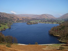 | Grasmere (lake) Grasmere is one of the smaller lakes of the English Lake District, in the county of Cumbria. Lake is 1680 yd long and 700 yd (640 m) wide, covering an area of 0.24 mi² (0.62 km²) The lake is fed and drained by the River Rothay, which flows through the village before entering the lake. The waters of the lake are leased by the Lowther Estate to the National Trust. |
 | Silver How Silver How is a fell in the English Lake District, standing over the village of Grasmere. How, derived from the Old Norse word haugr, is a common local term for a hill or mound. |
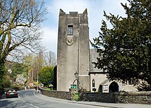 | St Oswald’s Church, Grasmere St Oswald’s Church is in the village of Grasmere, in the Lake District, Cumbria, England. It is an active Anglican parish church in the deanery of Windermere, the archdeaconry of Westmorland and Furness, and the diocese of Carlisle. The church is recorded in the National Heritage List for England as a designated Grade I listed building. |
Visit Grasmere (village) plaques
 5
5
plaques
here Grasmere (village) has 5 physical plaques in tourist plaque schemes for you to explore via Walkfo Grasmere (village) plaques audio map when visiting. Plaques like National Heritage’s “Blue Plaques” provide visual geo-markers to highlight points-of-interest at the places where they happened – and Walkfo’s AI has researched additional, deeper content when you visit Grasmere (village) using the app. Experience the history of a location when Walkfo local tourist guide app triggers audio close to each Grasmere (village) plaque. Explore Plaques & History has a complete list of Hartlepool’s plaques & Hartlepool history plaque map.


 Trying to encourage visitors to Grasmere (village)?