Welcome to Visit Glendale, California Places
The Walkfo guide to things to do & explore in Glendale, California
 Visit Glendale, California places using Walkfo for free guided tours of the best Glendale, California places to visit. A unique way to experience Glendale, California’s places, Walkfo allows you to explore Glendale, California as you would a museum or art gallery with audio guides.
Visiting Glendale, California Walkfo Preview
As of the 2010 census it had a population of 191,719. In 2019 the population was estimated at 204,765, making it the fourth-largest city in Los Angeles County. It is located about 10 miles (16 km) north of downtown Los Angeles. The Golden State, Ventura, Glendale, and Foothill freeways run through the city. When you visit Glendale, California, Walkfo brings Glendale, California places to life as you travel by foot, bike, bus or car with a mobile phone & headphones.
Glendale, California Places Overview: History, Culture & Facts about Glendale, California
Visit Glendale, California – Walkfo’s stats for the places to visit
With 29 audio plaques & Glendale, California places for you to explore in the Glendale, California area, Walkfo is the world’s largest heritage & history digital plaque provider. The AI continually learns & refines facts about the best Glendale, California places to visit from travel & tourism authorities (like Wikipedia), converting history into an interactive audio experience.
Glendale, California history
The area was long inhabited by the Tongva people (or “People of the Earth”), who were later renamed the Gabrieleños by the Spanish missionaries. In 1798, José María Verdugo received the Rancho San Rafael from Governor Diego de Borica, formalizing his possession and use of land on which he had been grazing livestock and farming since 1784. The property is the location of the Oak of Peace, where early Californio leaders including Pio Pico met in 1847 and decided to surrender to Lieutenant Colonel John C. Frémont.
Sundown town status
Until as late as the 1960s, Glendale was a sundown town. Nonwhites were required to leave city limits by a certain time each day or risk arrest and possible violence. The American Nazi Party moved their headquarters to El Monte in 1966.
Historic architecture
Glendale began its historic preservation program in 1977 with the designation of 28 properties as city landmarks. The register of Historic Resources now has over 100 properties. 11 properties in Glendale are listed on the National Register of Historic Places.
Glendale, California economy & business
Industry and development

Grand Central Airport was the first official terminal for the Los Angeles area, as well as the departure point for the first commercial west-to-east transcontinental flight flown by Charles Lindbergh. The Bob’s Big Boy chain of hamburger restaurants started in Glendale on East Colorado in August 1936, and the Baskin-Robbins ice cream parlors started in Adams Square in 1945. Glendale, along with Burbank, has served as a major production center for the U.S. entertainment industry.
Shopping
The downtown Glendale Galleria is anchored by Macy’s, Target, J. C. Penney, and Bloomingdales. The Americana at Brand is an outdoor mall which includes stores such as Tiffany & Co., H&M, Armani Exchange, True Religion, and Urban Outfitters.
Glendale, California geography / climate

Glendale is located in the southeastern San Fernando Valley. It is bordered to the north by the foothill communities of La Cañada Flintridge, La Crescenta, and Tujunga. The city is located 10 miles (16 km) north of downtown Los Angeles.
Geology
Several known earthquake faults criss-cross the Glendale area and adjacent mountains. The Sierra Madre and Hollywood faults are situated in the city’s northern and southwestern portions. The 1994 Northridge earthquake had an epicenter about 18 miles (29 km) from Glendale.
Climate
Glendale has a Mediterranean climate (Köppen climate classification Csa), with hot summers and mild winters with occasional rainfall. The warmest month is August and the coolest month is January. The annual average precipitation is just over 21 inches, mostly falling between November and April. The hills and mountains of northern Glendale very rarely have snow, owing to its warmer temperatures during the winter.
Why visit Glendale, California with Walkfo Travel Guide App?
 You can visit Glendale, California places with Walkfo Glendale, California to hear history at Glendale, California’s places whilst walking around using the free digital tour app. Walkfo Glendale, California has 29 places to visit in our interactive Glendale, California map, with amazing history, culture & travel facts you can explore the same way you would at a museum or art gallery with information audio headset. With Walkfo, you can travel by foot, bike or bus throughout Glendale, California, being in the moment, without digital distraction or limits to a specific walking route. Our historic audio walks, National Trust interactive audio experiences, digital tour guides for English Heritage locations are available at Glendale, California places, with a AI tour guide to help you get the best from a visit to Glendale, California & the surrounding areas.
“Curated content for millions of locations across the UK, with 29 audio facts unique to Glendale, California places in an interactive Glendale, California map you can explore.”
Walkfo: Visit Glendale, California Places Map
29 tourist, history, culture & geography spots
Glendale, California historic spots | Glendale, California tourist destinations | Glendale, California plaques | Glendale, California geographic features |
| Walkfo Glendale, California tourism map key: places to see & visit like National Trust sites, Blue Plaques, English Heritage locations & top tourist destinations in Glendale, California | |||
Best Glendale, California places to visit
Glendale, California has places to explore by foot, bike or bus. Below are a selection of the varied Glendale, California’s destinations you can visit with additional content available at the Walkfo Glendale, California’s information audio spots:
| Glendale Galleria The Glendale Galleria is a large regional shopping center and office complex located in downtown Glendale, California, United States. Opened in 1973 with 1.6 million square feet of retail space, it is the fourth largest mall in Los Angeles County. |
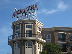 | Americana at Brand The Americana at Brand is a large shopping, dining, entertainment and residential complex in Glendale, California. The property was built and is owned and operated by Los Angeles businessman Rick J. Caruso. The complex’s 82 retail shops include Barneys New York, Nordstrom, XXI Forever and David Yurman. |
 | Alex Theatre The Alex Theatre is a landmark located at 216 North Brand Boulevard in Glendale, California, United States. It is currently owned by the city of Glendale and operated by Glendale Arts. |
 | Glendale Public Library Glendale Public Library is a name used for a group of seven library branches in Glendale, California, under the Library, Arts & Culture Department. GPL’s branches have hosted many events, and offers numerous services for customers. |
 | Autry Museum of the American West Autry Museum of the American West is a museum dedicated to exploring an inclusive history of the West. Founded in 1988, the museum presents a wide range of exhibitions and public programs. It has two sites and attracts about 150,000 visitors annually. |
 | Holy Family Catholic Church (Glendale, California) Holy Family Catholic Church is a Catholic church, an elementary school and an all-girls high school. Founded in 1907, it is the oldest parish in Glendale, California. |
 | La Kretz Bridge La Kretz Bridge is the 2nd bridge crossing the Los Angeles River to be completed in the 21st century. The bridge is noted for a white spire that rises 126 feet (38 m) and uses 300,000 pounds of steel. |
 | 2005 Glendale train crash The 2005 Glendale train crash occurred on January 26, 2005, at 6:03 a.m. PST. It is the second-deadliest incident in the history of Metrolink, the commuter railroad in the Los Angeles, California, area. It was overtaken as the deadliest by the 2008 Chatsworth train collision. |
 | Grand Central Airport (California) The airport was an important facility for the growing Los Angeles suburb of Glendale in the 1920s. The terminal, located at 1310 Air Way, was built in 1928 and still exists. The location of the single concrete 3,800-foot (1,200 m) runway has been preserved, but is now a public street. |
 | Tam O’Shanter Inn The Tam O’Shanter Inn is one of Los Angeles’ oldest restaurants. Walt Disney was a frequent patron there. It is known for its prime rib and Yorkshire pudding. |
Visit Glendale, California plaques
 0
0
plaques
here Glendale, California has 0 physical plaques in tourist plaque schemes for you to explore via Walkfo Glendale, California plaques audio map when visiting. Plaques like National Heritage’s “Blue Plaques” provide visual geo-markers to highlight points-of-interest at the places where they happened – and Walkfo’s AI has researched additional, deeper content when you visit Glendale, California using the app. Experience the history of a location when Walkfo local tourist guide app triggers audio close to each Glendale, California plaque. Currently No Physical Plaques.


 Trying to encourage visitors to Glendale, California?