Welcome to Visit Garn-yr-erw Places The Walkfo guide to things to do & explore in Garn-yr-erw
Visit Garn-yr-erw places using Walkfo for free guided tours of the best Garn-yr-erw places to visit. A unique way to experience Garn-yr-erw’s places, Walkfo allows you to explore Garn-yr-erw as you would a museum or art gallery with audio guides.
Visiting Garn-yr-erw Walkfo Preview Garn-yr-erw is a village in south eastern Wales, lying at the source of the Afon Llwyd north of Blaenavon and Pontypool. The village lies at an altitude of approx 400 metres on the side of Gilwern Hill, Monmouthshire. When you visit Garn-yr-erw, Walkfo brings Garn-yr-erw places to life as you travel by foot, bike, bus or car with a mobile phone & headphones.
Garn-yr-erw Places Overview: History, Culture & Facts about Garn-yr-erw
Visit Garn-yr-erw – Walkfo’s stats for the places to visit
With 24 audio plaques & Garn-yr-erw places for you to explore in the Garn-yr-erw area, Walkfo is the world’s largest heritage & history digital plaque provider. The AI continually learns & refines facts about the best Garn-yr-erw places to visit from travel & tourism authorities (like Wikipedia), converting history into an interactive audio experience.
Why visit Garn-yr-erw with Walkfo Travel Guide App?
You can visit Garn-yr-erw places with Walkfo Garn-yr-erw to hear history at Garn-yr-erw’s places whilst walking around using the free digital tour app. Walkfo Garn-yr-erw has 24 places to visit in our interactive Garn-yr-erw map, with amazing history, culture & travel facts you can explore the same way you would at a museum or art gallery with information audio headset. With Walkfo, you can travel by foot, bike or bus throughout Garn-yr-erw, being in the moment, without digital distraction or limits to a specific walking route. Our historic audio walks, National Trust interactive audio experiences, digital tour guides for English Heritage locations are available at Garn-yr-erw places, with a AI tour guide to help you get the best from a visit to Garn-yr-erw & the surrounding areas.
“Curated content for millions of locations across the UK, with 24 audio facts unique to Garn-yr-erw places in an interactive Garn-yr-erw map you can explore.”
Walkfo Garn-yr-erw tourism map key: places to see & visit like National Trust sites, Blue Plaques, English Heritage locations & top tourist destinations in Garn-yr-erw
Best Garn-yr-erw places to visit
Garn-yr-erw has places to explore by foot, bike or bus. Below are a selection of the varied Garn-yr-erw’s destinations you can visit with additional content available at the Walkfo Garn-yr-erw’s information audio spots:
Blaenavon Blaenavon is both a town and a community in Torfaen county borough, Wales. It is within the boundaries of the historic county of Monmouthshire and the preserved county of Gwent. Parts of the town and surrounding country are inscribed as a World Heritage Site by UNESCO.
Coity Mountain Coity Mountain (also spelled Coety Mountain, Welsh: Mynydd Coety) is a flat-topped mountain in the South Wales Valleys. The highest points of Torfaen and Blaenau Gwent unitary authorities are at the summit. The summit is also known as Twyn Ffynhonnau Goerion.
Smart’s Bridge Smart’s Bridge, Llanelly, Monmouthshire, was built in 1824. It gave access to the Clydach Ironworks, the most significant industrial enterprise in the gorge. The bridge was designated a Grade II* listed structure in 2000.
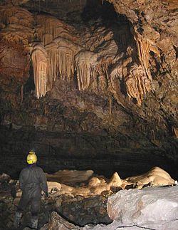
Ogof Craig a Ffynnon Ogof Craig a Ffynnon (Welsh for “Rock and Fountain Cave”) is a cave in Wales. The cave is located at the base of a quarried rockface in Clydach Gorge. Water flowing out of the cave is a resurgence of water draining off Llangatock Mountain above.
Clydach House, Llanelly Clydach House, Llanelly, Monmouthshire is a house dating from 1693. Constructed as the home for the manager of an ironworks in the nearby Clydacht Gorge, it is a Grade II* listed building.
Cwm Clydach National Nature Reserve Cwm Clydach National Nature Reserve is a 24.8 hectares (61 acres) area of steeply sloping valley-side. It is protected for its ancient semi-natural beech woods, designated by the Nature Conservancy Council.
Gilwern Hill, Monmouthshire Gilwern Hill is a 441 m high hill in the Brecon Beacons National Park in Monmouthshire, Wales. It lies west of the Blorenge and is a Site of Special Scientific Interest.
Garnddyrys Forge Garnddyrys Forge was an iron foundry in Wales that operated from about 1817–60. It operated on a tramroad between Blaenavon and the Brecknock and Abergavenny Canal. 450 people lived around the ironworks.
Visit Garn-yr-erw plaques
0 plaques hereGarn-yr-erw has 0 physical plaques in tourist plaque schemes for you to explore via Walkfo Garn-yr-erw plaques audio map when visiting. Plaques like National Heritage’s “Blue Plaques” provide visual geo-markers to highlight points-of-interest at the places where they happened – and Walkfo’s AI has researched additional, deeper content when you visit Garn-yr-erw using the app. Experience the history of a location when Walkfo local tourist guide app triggers audio close to each Garn-yr-erw plaque. Currently No Physical Plaques.
Experience Garn-yr-erw audio walks & tours
Walkfo guides for things to do / places to visit in Garn-yr-erw allows exploration as you would do an art gallery or museum. Walk close to one of Garn-yr-erw’s 24 historic places & our digital tour guide will create an audio story for that spot. With headphone connected, you can explore Garn-yr-erw freely by foot, bike or bus – with your own personal tour guide in your pocket.
Explore Garn-yr-erw Map App
Our visit Garn-yr-erw map shows you things-to-do & places you can visit in Garn-yr-erw & surrounding areas using the Walkfo digital audio tour guide app. Each spot has plaque, building, street or area information on history, culture or tourism.
You can set your Walkfo’s Garn-yr-erw tourist map to find historic & tourism spots within 1km, 3km & 5km of the Garn-yr-erw centre, depending on how far you plan to explore whilst you visit Garn-yr-erw area at LONG:-3.1098, LAT:51.7837.
Walkfo App
Walkfo
Walkfo is free to download & use (for a limited time period), so if you are looking to explore Garn-yr-erw, go to your App Store to search for “Walkfo” or follow a links below and install on your mobile phone. Walkfo is designed for use with headphones or AirPods, so you can walk & explore whilst learning about the things around you without digital distraction.
Things to do & visit in Garn-yr-erw / surrounding areas
● Blaenavon ● Blaenavon Industrial Landscape ● Blaenavon Hospital ● Blaenavon Ironworks ● Forge Side ● Big Pit National Coal Museum ● Coity Mountain ● Garn-yr-erw ● Clydach Gorge ● Smart’s Bridge ● Clydach, Monmouthshire ● Ogof Craig a Ffynnon ● Clydach House, Llanelly ● Cwm Clydach National Nature Reserve ● River Clydach, Monmouthshire ● Gilwern Hill, Monmouthshire ● Pwll Du Tunnel ● Ogof Draenen ● Pwll Du ● Dyne Steel Incline ● Coalbrookvale ● Blaina & District Hospital ● Garnddyrys Forge ● Blorenge
Getting to / around Garn-yr-erw – transport link, station & street map
Getting around in Garn-yr-erw using public transportation may include road, street, train, underground, bus or tram transport options. Walkfo has identified the following Garn-yr-erw places with historic / cultural / factual content when you visit:
Local Garn-yr-erw Public Transport Stations
Garn-yr-erw Notable Streets & Road Destinations
Blaenavon High Level railway station
Blaenavon Low Level railway station
Big Pit Halt railway station
Gelli Felen Halt railway station
Abergavenny transmitting station
Waenavon railway station
Whistle Inn Halt railway station
Clydach railway station
Gilwern Halt railway station
[transportsummary]
Local Garn-yr-erw historians & Garn-yr-erw tour guides
Trying to encourage visitors to Garn-yr-erw? Walkfo has millions audio places already available but Walkfo Creator gives Garn-yr-erw’s places, attractions & landmarks ability to create their own unique outdoor audio museums & using our simple & easy to use Walkfo Creator. – Creating a new audio experience for your Garn-yr-erw place is free* and quick (15+ minutes if you prepare text content) to use, with Walkfo Creator doing the hard work of generating AI audio files for geo-spots from the text you provide with a simply click on a map. – The 100 Amazing Garn-yr-erw Places is just one example of an outdoor museum created using Walkfo Creator (pictured to the left) for people to safely explore during Covid-19 times whilst visiting a city. Our tool is open to tourism organisations, travel destinations & National Trust locations to create their own audio walks to offer free when people visit Garn-yr-erw destinations. – Walkfo itself is looking to partner with websites offering things-to-do / what’s on events listings to enhance the content of our ‘visit-Garn-yr-erw’ web pages (for example: www.visitGarn-yr-erw.com). If you are interested in partnering, please contact us to discuss options.
* Walkfo Creator is free to use for a limited number of audio spots within a map with a license fee applicable when more than 20 audio spots within location walk are created. v1.1336
 Visit Garn-yr-erw places using Walkfo for free guided tours of the best Garn-yr-erw places to visit. A unique way to experience Garn-yr-erw’s places, Walkfo allows you to explore Garn-yr-erw as you would a museum or art gallery with audio guides.
 You can visit Garn-yr-erw places with Walkfo Garn-yr-erw to hear history at Garn-yr-erw’s places whilst walking around using the free digital tour app. Walkfo Garn-yr-erw has 24 places to visit in our interactive Garn-yr-erw map, with amazing history, culture & travel facts you can explore the same way you would at a museum or art gallery with information audio headset. With Walkfo, you can travel by foot, bike or bus throughout Garn-yr-erw, being in the moment, without digital distraction or limits to a specific walking route. Our historic audio walks, National Trust interactive audio experiences, digital tour guides for English Heritage locations are available at Garn-yr-erw places, with a AI tour guide to help you get the best from a visit to Garn-yr-erw & the surrounding areas.


 0
0


 Trying to encourage visitors to Garn-yr-erw?