Welcome to Visit Fornside Places The Walkfo guide to things to do & explore in Fornside
Visit Fornside places using Walkfo for free guided tours of the best Fornside places to visit. A unique way to experience Fornside’s places, Walkfo allows you to explore Fornside as you would a museum or art gallery with audio guides.
Visiting Fornside Walkfo Preview Fornside is a hamlet in the Lake District National Park of Cumbria, England. It is located about 4 miles southeast of Keswick, along the B5322 road. The name is believed to be of Scandinavian origin, Forn meaning “old” or “former” When you visit Fornside, Walkfo brings Fornside places to life as you travel by foot, bike, bus or car with a mobile phone & headphones.
Fornside Places Overview: History, Culture & Facts about Fornside
Visit Fornside – Walkfo’s stats for the places to visit
With 13 audio plaques & Fornside places for you to explore in the Fornside area, Walkfo is the world’s largest heritage & history digital plaque provider. The AI continually learns & refines facts about the best Fornside places to visit from travel & tourism authorities (like Wikipedia), converting history into an interactive audio experience.
Why visit Fornside with Walkfo Travel Guide App?
You can visit Fornside places with Walkfo Fornside to hear history at Fornside’s places whilst walking around using the free digital tour app. Walkfo Fornside has 13 places to visit in our interactive Fornside map, with amazing history, culture & travel facts you can explore the same way you would at a museum or art gallery with information audio headset. With Walkfo, you can travel by foot, bike or bus throughout Fornside, being in the moment, without digital distraction or limits to a specific walking route. Our historic audio walks, National Trust interactive audio experiences, digital tour guides for English Heritage locations are available at Fornside places, with a AI tour guide to help you get the best from a visit to Fornside & the surrounding areas.
“Curated content for millions of locations across the UK, with 13 audio facts unique to Fornside places in an interactive Fornside map you can explore.”
Walkfo Fornside tourism map key: places to see & visit like National Trust sites, Blue Plaques, English Heritage locations & top tourist destinations in Fornside
Best Fornside places to visit
Fornside has places to explore by foot, bike or bus. Below are a selection of the varied Fornside’s destinations you can visit with additional content available at the Walkfo Fornside’s information audio spots:
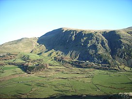
Hart Side Hart Side (the hill side frequented by harts) is a subsidiary top on one of the east ridges of Stybarrow Dodd, which is a mountain (or fell) in the English Lake District. With a height of 2,480 feet (756 m) Hart Side rises above the col separating it from Green Side by 75 feet (23 m)
St John’s Church, St John’s in the Vale St John’s Church is an active Anglican parish church in the Vale, Cumbria. Its benefice is united with those of St Mary, Threlkeld, and Wythburn Church. The church is recorded in the National Heritage List for England as a Grade II listed building.
High Rigg High Rigg is a small fell located in the English Lake District. It is surrounded on all sides by higher fells but not connected by any obvious ridge. This separation ensures that it is a Marilyn (a hill with topographic prominence of at least 150m)
Bleaberry Fell Bleaberry Fell is a fell in the Lake District in Cumbria, England, with a height of 590 metres (1,936 feet) It stands on the main watershed between Borrowdale and Thirlmere and can be climbed from either flank. Walla Crag is a subsidiary top of the fell.
Raven Crag Raven Crag is a fell in the Lake District that overlooks Thirlmere reservoir. It has subsidiary summits The Benn and Castle Crag.
Clough Head Clough Head ( /klʌf hɛd/) is a fell, or hill, in the English Lake District. It marks the northern end of the main ridge of the Helvellyn range. It forms the steep eastern side of the tranquil valley of St John’s in the Vale.
Great Dodd Great Dodd (meaning: big round hill) is a mountain or fell in the English Lake District. It stands on the main ridge of the Helvellyn range, a line of mountains which runs in a north-south direction between the lakes of Thirlmere and Ullswater. It is the highest of the fells in the range to the north of Sticks Pass.
Watson’s Dodd Watson’s Dodd is a minor rise on the main ridge of the Helvellyn range in the Eastern Fells. At its foot is the imposing crag of Castle Rock, on which rock climbers have developed some 60 named routes.
Stybarrow Dodd The summit of Stybarrow Dodd is a smooth, rounded, grassy dome, like those of its two northern neighbours, Watson’s Dodd and Great Dodd. All three are covered by the same sheet of volcanic rock.
Visit Fornside plaques
0 plaques hereFornside has 0 physical plaques in tourist plaque schemes for you to explore via Walkfo Fornside plaques audio map when visiting. Plaques like National Heritage’s “Blue Plaques” provide visual geo-markers to highlight points-of-interest at the places where they happened – and Walkfo’s AI has researched additional, deeper content when you visit Fornside using the app. Experience the history of a location when Walkfo local tourist guide app triggers audio close to each Fornside plaque. Currently No Physical Plaques.
Experience Fornside audio walks & tours
Walkfo guides for things to do / places to visit in Fornside allows exploration as you would do an art gallery or museum. Walk close to one of Fornside’s 13 historic places & our digital tour guide will create an audio story for that spot. With headphone connected, you can explore Fornside freely by foot, bike or bus – with your own personal tour guide in your pocket.
Explore Fornside Map App
Our visit Fornside map shows you things-to-do & places you can visit in Fornside & surrounding areas using the Walkfo digital audio tour guide app. Each spot has plaque, building, street or area information on history, culture or tourism.
You can set your Walkfo’s Fornside tourist map to find historic & tourism spots within 1km, 3km & 5km of the Fornside centre, depending on how far you plan to explore whilst you visit Fornside area at LONG:-3.053, LAT:54.575.
Walkfo App
Walkfo
Walkfo is free to download & use (for a limited time period), so if you are looking to explore Fornside, go to your App Store to search for “Walkfo” or follow a links below and install on your mobile phone. Walkfo is designed for use with headphones or AirPods, so you can walk & explore whilst learning about the things around you without digital distraction.
Things to do & visit in Fornside / surrounding areas
● Hart Side ● St John’s Church, St John’s in the Vale ● High Rigg ● St John’s in the Vale ● Bleaberry Fell ● Raven Crag ● Clough Head ● Fornside ● Great Dodd ● Watson’s Dodd ● Legburthwaite ● Stybarrow Dodd ● Thirlmere Aqueduct
Getting to / around Fornside – transport link, station & street map
Getting around in Fornside using public transportation may include road, street, train, underground, bus or tram transport options. Walkfo has identified the following Fornside places with historic / cultural / factual content when you visit:
Local Fornside Public Transport Stations
Fornside Notable Streets & Road Destinations
[transportsummary]
Local Fornside historians & Fornside tour guides
Trying to encourage visitors to Fornside? Walkfo has millions audio places already available but Walkfo Creator gives Fornside’s places, attractions & landmarks ability to create their own unique outdoor audio museums & using our simple & easy to use Walkfo Creator. – Creating a new audio experience for your Fornside place is free* and quick (15+ minutes if you prepare text content) to use, with Walkfo Creator doing the hard work of generating AI audio files for geo-spots from the text you provide with a simply click on a map. – The 100 Amazing Fornside Places is just one example of an outdoor museum created using Walkfo Creator (pictured to the left) for people to safely explore during Covid-19 times whilst visiting a city. Our tool is open to tourism organisations, travel destinations & National Trust locations to create their own audio walks to offer free when people visit Fornside destinations. – Walkfo itself is looking to partner with websites offering things-to-do / what’s on events listings to enhance the content of our ‘visit-Fornside’ web pages (for example: www.visitFornside.com). If you are interested in partnering, please contact us to discuss options.
* Walkfo Creator is free to use for a limited number of audio spots within a map with a license fee applicable when more than 20 audio spots within location walk are created. v1.1336
 Visit Fornside places using Walkfo for free guided tours of the best Fornside places to visit. A unique way to experience Fornside’s places, Walkfo allows you to explore Fornside as you would a museum or art gallery with audio guides.
 You can visit Fornside places with Walkfo Fornside to hear history at Fornside’s places whilst walking around using the free digital tour app. Walkfo Fornside has 13 places to visit in our interactive Fornside map, with amazing history, culture & travel facts you can explore the same way you would at a museum or art gallery with information audio headset. With Walkfo, you can travel by foot, bike or bus throughout Fornside, being in the moment, without digital distraction or limits to a specific walking route. Our historic audio walks, National Trust interactive audio experiences, digital tour guides for English Heritage locations are available at Fornside places, with a AI tour guide to help you get the best from a visit to Fornside & the surrounding areas.


 0
0


 Trying to encourage visitors to Fornside?