Welcome to Visit Exeter Places
The Walkfo guide to things to do & explore in Exeter
 Visit Exeter places using Walkfo for free guided tours of the best Exeter places to visit. A unique way to experience Exeter’s places, Walkfo allows you to explore Exeter as you would a museum or art gallery with audio guides.
Visiting Exeter Walkfo Preview
In Roman Britain, Exeter was established as the base of Legio II Augusta under the personal command of Vespasian. Exeter Cathedral, founded in the 11th century, became Anglican in the 16th-century English Reformation. It is the county town of Devon and home to the headquarters of Devon County Council. When you visit Exeter, Walkfo brings Exeter places to life as you travel by foot, bike, bus or car with a mobile phone & headphones.
Exeter Places Overview: History, Culture & Facts about Exeter
Visit Exeter – Walkfo’s stats for the places to visit
With 94 audio plaques & Exeter places for you to explore in the Exeter area, Walkfo is the world’s largest heritage & history digital plaque provider. The AI continually learns & refines facts about the best Exeter places to visit from travel & tourism authorities (like Wikipedia), converting history into an interactive audio experience.
Exeter history
Prehistory
Exeter began as settlements on a dry ridge ending in a spur overlooking a navigable river teeming with fish, with fertile land nearby. Coins have been discovered from the Hellenistic kingdoms, suggesting the existence of a settlement trading with the Mediterranean as early as 250 BC.
Roman times
The Romans established a 42-acre (17 ha) ‘playing-card’ shaped (rectangle) fort (Latin: castrum) named Isca around AD 55. The fort was the southwest terminus of the Fosse Way (Route 15 of the Antonine Itinerary) It served as the base of the Second Augustan Legion (Legio II Augusta) for the next 20 years before they moved to Caerleon in Wales. To distinguish the two, the Romans also referred to Exeter as Isca Dumnoniorum, “Watertown of the Dumnontii” The fortress was abandoned around the year 75, its grounds were converted to civilian.
Medieval times
Bishop Ussher identified the Cair Pensa vel Coyt, listed among the 28 cities of Britain by the History of the Britons, as Isca, although David Nash Ford read it as a reference to Penselwood and thought it more likely to be Lindinis (modern Ilchester). Nothing is certainly known of Exeter from the time of the Roman withdrawal from Britain around the year 410 until the seventh century. By that time, the city was held by the Saxons, who had arrived in Exeter after defeating the British Dumnonians at Peonnum in Somerset in 658. It seems likely that the Saxons maintained a quarter of the city for the Britons under their own laws around present-day Bartholomew Street, which was known as “Britayne” Street until 1637 in memory of its former occupants. Exeter was known to the Saxons as Escanceaster. In 876, it was attacked and briefly captured by Danish Vikings. Alfred the Great drove them out the next summer. Over the next few years, he elevated Exeter to one of the four burhs in Devon, rebuilding its walls on the Roman lines. These permitted the city to fend off another attack and siege by the Danes in 893. King Athelstan again strengthened the walls around 928, and at the same time drove out the remaining Britons from the city. (It is uncertain, though, whether they had lived in the city continuously since the Roman period or returned from the countryside when Alfred strengthened its defences.) According to William of Malmesbury, they were sent beyond the River Tamar, which was fixed as the boundary of Devon. (This may, however, have served as a territorial boundary within the former kingdom of Dumnonia as well.) Other references suggest that the British simply moved to what is now the St David’s area, not far outside Exeter’s walls. The quarter vacated by the Britons was apparently adapted as “the earl’s burh” and was still named Irlesberi in the 12th century. In 1001, the Danes again failed to get into the city, but they were able to plunder it in 1003 because they were let in, for unknown reasons, by the French reeve of Emma of Normandy, who had been given the city as part of her dowry on her marriage to Æthelred the Unready the previous year. Two years after the Norman conquest of England, Exeter rebelled against King William. Gytha Thorkelsdóttir, the mother of the slain King Harold, was living in the city at the time, and William promptly marched west and initiated a siege. After 18 days, William accepted the city’s honourable surrender, swearing an oath not to harm the city or increase its ancient tribute. However, William quickly arranged for the building of Rougemont Castle to strengthen Norman control over the area. Properties owned by Saxon landlords were transferred into Norman hands and, on the death of Bishop Leofric in 1072, the Norman Osbern FitzOsbern was appointed his successor. In 1136, early in the Anarchy, Rougemont Castle was held against King Stephen by Baldwin de Redvers. Redvers submitted only after a three-month siege, not when the three wells in the castle ran dry, but only after the exhaustion of the large supplies of wine that the garrison was using for drinking, baking, cooking, and putting out fires set by the besiegers. During the siege, King Stephen built an earthen fortification at the site now known (erroneously) as Danes Castle. The city held a weekly market for the benefit of its citizens from at least 1213, and by 1281 Exeter was the only town in the south-west to have three market days per week. There are also records of seven annual fairs, the earliest of which dates from 1130, and all of which continued until at least the early 16th century. Prior to the expulsion of the Jews of England in 1290, Exeter was home to England’s most westerly Jewish community. During the high medieval period, both the cathedral clergy and the citizens enjoyed access to sophisticated aqueduct systems which brought pure drinking water into the city from springs in the neighbouring parish of St Sidwell’s. For part of their length, these aqueducts were conveyed through a remarkable network of tunnels, or underground passages, which survive largely intact and which may still be visited today. Exeter and Bristol hosted the first recorded Common Council in the Medieval England. The first detailed and continuous evidence of its existence and activity was founded after 1345 Formed by twelve “better and more discreet men” (in Latin: duodecim meliores), reelected each year, it was originally designed to control the abuse of the Major and of his four stewards, which respectively presided over the borough court and the provost court. The members of the Common Council come from the same elite of wealthy citizens, as did the major and the stewards and this concern introduced a second conflict of interests in the government organism of the city.
Modern times

In 1537, the city was made a county corporate. In 1549, the city successfully withstood a month-long siege by the so-called Prayer Book rebels: Devon and Cornish folk who had been infuriated by the radical religious policies of King Edward VI. The insurgents occupied the suburbs of Exeter, burnt down two of the city gates and attempted to undermine the city walls, but were eventually forced to abandon the siege after they had been worsted in a series of bloody battles with the king’s army. A number of rebels were executed in the immediate aftermath of the siege. The Livery Dole almshouses and chapel at Heavitree were founded in March 1591 and finished in 1594. When John Hooker was appointed to the city payroll in 1561, he created the Court of Orphans as a municipal government for families broken by the premature death of their major economic source. He also was made the Common Council as the legal owner of any estate left to the orphan children of Exeter, until they have reached the age of 21 to be partially paid back. The orphan tax was used to fund the construction of the Exeter canal. The city’s motto, Semper fidelis, is traditionally held to have been suggested by Elizabeth I, in acknowledgement of the city’s contribution of ships to help defeat the Spanish Armada in 1588; however its first documented use is in 1660. Schools in Exeter teach that the motto was bestowed by Charles II in 1660 at the Restoration due to Exeter’s role in the English Civil War. When in 1638 Reverend John Wheelwright was exiled from the Massachusetts Bay Colony and subsequently established a community on the banks of the Squamscott River, he named the region Exeter after its Devonian counterpart. During the American Revolution it became the capital of New Hampshire. Exeter was secured for Parliament at the beginning of the English Civil War, and its defences very much strengthened, but in September 1643 it was captured by the Cornish Royalist Army led by Prince Maurice. Thereafter, the city remained firmly under the king’s control until near the end of the war, being one of the final Royalist cities to fall into Parliamentarian hands. The surrender of Exeter was negotiated in April 1646 at Poltimore House by Thomas Fairfax. During this period, Exeter was an economically powerful city, with a strong trade of wool. This was partly due to the surrounding area which was “more fertile and better inhabited than that passed over the preceding day” according to Count Lorenzo Magalotti who visited the city when he was 26 years old. Magalotti writes of over thirty thousand people being employed in the county of Devon as part of the wool and cloth industries, merchandise that was sold to “the West Indies, Spain, France and Italy”. Celia Fiennes also visited Exeter during this period, in the early 1700s. She remarked on the “vast trade” and “incredible quantity” in Exeter, recording that “it turns the most money in a week of anything in England”, between £10,000 and £15,000. Early in the Industrial Revolution, Exeter’s industry developed on the basis of locally available agricultural products and, since the city’s location on a fast-flowing river gave it ready access to water power, an early industrial site developed on drained marshland to the west of the city, at Exe Island. However, when steam power replaced water in the 19th century, Exeter was too far from sources of coal (or iron) to develop further. As a result, the city declined in relative importance and was spared the rapid 19th-century development that changed many historic European cities. Extensive canal redevelopments during this period further expanded Exeter’s economy, with “vessels of 15 to 16 tons burthen [bringing] up goods and merchandise from Topsham to the City Quay”. In 1778 a new bridge across the Exe was opened to replace the old medieval bridge. Built at a cost of £30,000, it had three arches and was built of stone. In 1832, cholera, which had been erupting all across Europe, reached Exeter. The only known documentation of this event was written by Dr Thomas Shapter, one of the medical doctors present during the epidemic. The first railway to arrive in Exeter was the Bristol and Exeter Railway that opened a station at St Davids on the western edge in 1844. The South Devon Railway Company extended the line westwards to Plymouth, opening their own smaller station at St Thomas, above Cowick Street. A more central railway station, that at Queen Street, was opened by the London and South Western Railway in 1860 when it opened its alternative route to London. Butchers Lloyd Maunder moved to their present base in 1915, to gain better access to the Great Western Railway for transportation of meat products to London. The first electricity in Exeter was provided by the Exeter Electric Light Company, which was formed at the end of the 1880s, but it was municipalised in 1896 and became the City of Exeter Electricity Company. The first horse-drawn trams in Exeter were introduced in 1882 with 3 lines radiating from the city’s East Gate. One line went to St David’s station via New North Road, the Obelisk (where the Clock Tower now stands) and St David’s Hill. The second line went out along Heavitree Road to Livery Dole and the third went to Mount Pleasant along Sidwell Street. There was a depot off New North Road.
20th century

A new bridge across the Exe was opened on 29 March 1905, replacing the former Georgian bridge. In 1905, electric trams replaced the horse trams with a new route which passed along the High Street, down Fore Street and over the new Exe Bridge. Exeter was bombed by the German Luftwaffe in the Second World War when a total of 18 raids between 1940 and 1942 flattened much of the city centre.
21st century
A £30 million improvement scheme for the flood defences was approved in March 2015. A community currency for the city, the Exeter Pound, was introduced in 2015 and dissolved in 2018. A serious fire broke out in buildings in central Exeter on 28 October 2016. A Second World War bomb was uncovered at a construction site and more than 2,600 people were evacuated.
Exeter culture & places
Literature

The Exeter Book, an anthology of Anglo Saxon poetry, is conserved in the vaults of Exeter Cathedral. Predominantly, the Book incorporates shorter poems, several religious pieces, and a series of riddles, a handful of which are famously lewd. In 2019, the city became a UNESCO City of Literature.
Theatre
The Northcott Theatre is situated in the Streatham campus of the University of Exeter. The Cygnet Theatre in Friars Walk is the home of a Theatre Training Theatre. The Bike Shed Theatre and Cocktail Bar opened in September 2010 before permanently closing in March 2018.
Music
Coldplay singer Chris Martin grew up in a Grade II-listed Georgian house in Whitestone, Exeter. The largest orchestra based in Exeter is the EMG Symphony Orchestra.
Museums and Galleries
The Royal Albert Memorial Museum in Queen Street is Exeter’s predominant museum. The University of Exeter has an extensive fine art collection. Exeter Phoenix is one of South West England’s leading contemporary arts venues.
Newspapers
Exeter Flying Post was revived in 1976 as an alternative community magazine. Exeposé, the University’s student newspaper, printed fortnightly. Express and Echo, published weekly on Thursdays. The Western Morning News, a daily regional paper.
Television
BBC Spotlight and ITV West Country provide Exeter with regional news output. BBC Spotlight is broadcast from Plymouth, ITV Westcountry is from Bristol. St Thomas and Stockland Hill transmitters both completed digital switchover.
Twin towns

Exeter is twinned with Rennes in France, Bad Homburg in Germany, Yaroslavl in Russia, and Terracina in Italy.
Exeter landmarks

Among the notable buildings in Exeter are: Exeter Castle Hall Hall Hall, which was built in the 1920s. Exeter Hall Hall is one of the most famous buildings in the UK.
Religious buildings
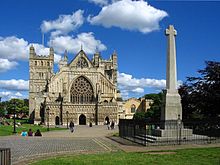
Exeter Cathedral was founded in 1087 and was home to Benedictine monks for over 400 years, until it was closed and partly demolished by Henry VIII. St Nicholas Priory in Mint Lane, the remains of a monastery, later used as a private house and now a museum owned by the city council.
Secular buildings
The ruins of Rougemont Castle, built soon after the Norman Conquest, were still in use as a County Court until early 2006 when a new Crown Courts building opened. Parliament Street in the city centre is one of the narrowest streets in the world. The Guildhall, which has medieval foundations, is claimed to be the oldest municipal building in England.
Northernhay Gardens
Northernhay Gardens is the oldest public open space in England. It was laid out in 1612 as a pleasure walk for Exeter residents.
Exeter geography / climate

The city of Exeter was established on the eastern bank of the River Exe on a ridge of land backed by a steep hill. It is at this point that the Exe opens onto a wide flood plain and estuary which results in quite common flooding. Exeter sits on sandstone and conglomerate geology, although the structure of the surrounding areas is varied.
Climate
The hottest month is July with an average high of 21.7 °C (71.1 °F) October is the wettest month with 88.9 millimetres (3.50 in) of rain. The highest recorded temperature in Exeter was 33.5 °C in June 1976.
Why visit Exeter with Walkfo Travel Guide App?
 You can visit Exeter places with Walkfo Exeter to hear history at Exeter’s places whilst walking around using the free digital tour app. Walkfo Exeter has 94 places to visit in our interactive Exeter map, with amazing history, culture & travel facts you can explore the same way you would at a museum or art gallery with information audio headset. With Walkfo, you can travel by foot, bike or bus throughout Exeter, being in the moment, without digital distraction or limits to a specific walking route. Our historic audio walks, National Trust interactive audio experiences, digital tour guides for English Heritage locations are available at Exeter places, with a AI tour guide to help you get the best from a visit to Exeter & the surrounding areas.
“Curated content for millions of locations across the UK, with 94 audio facts unique to Exeter places in an interactive Exeter map you can explore.”
Walkfo: Visit Exeter Places Map
94 tourist, history, culture & geography spots
Exeter historic spots | Exeter tourist destinations | Exeter plaques | Exeter geographic features |
| Walkfo Exeter tourism map key: places to see & visit like National Trust sites, Blue Plaques, English Heritage locations & top tourist destinations in Exeter | |||
Best Exeter places to visit
Exeter has places to explore by foot, bike or bus. Below are a selection of the varied Exeter’s destinations you can visit with additional content available at the Walkfo Exeter’s information audio spots:

Digby Hospital
Digby Hospital was a mental health facility in Digby, Devon, England. It was built in the 1930s and was located in the town of Digby.

Equestrian statue of Sir Redvers Buller
Equestrian statue of General Sir Redvers Buller stands at the junction of Hele Road and New North Road, Exeter. It was unveiled in 1905, and the bronze statue is mounted on a plinth of Cornish granite.
Visit Exeter plaques
 55
55
plaques
here Exeter has 55 physical plaques in tourist plaque schemes for you to explore via Walkfo Exeter plaques audio map when visiting. Plaques like National Heritage’s “Blue Plaques” provide visual geo-markers to highlight points-of-interest at the places where they happened – and Walkfo’s AI has researched additional, deeper content when you visit Exeter using the app. Experience the history of a location when Walkfo local tourist guide app triggers audio close to each Exeter plaque. Explore Plaques & History has a complete list of Hartlepool’s plaques & Hartlepool history plaque map.


 Trying to encourage visitors to Exeter?