Welcome to Visit Egerton, Greater Manchester Places
The Walkfo guide to things to do & explore in Egerton, Greater Manchester
 Visit Egerton, Greater Manchester places using Walkfo for free guided tours of the best Egerton, Greater Manchester places to visit. A unique way to experience Egerton, Greater Manchester’s places, Walkfo allows you to explore Egerton, Greater Manchester as you would a museum or art gallery with audio guides.
Visiting Egerton, Greater Manchester Walkfo Preview
Egerton, (pronounced “edgerton”), is a village in the unparished area of South Turton, in the northern part of the Metropolitan Borough of Bolton, Greater Manchester. It is situated three miles north of Bolton and 12 miles north west of Manchester city centre within the West Pennine Moors. The name Egerton was brought to the area in 1663 when Ralph Egerton married the step-daughter of James Walmsley, after which their property became known as Egerton’s. When you visit Egerton, Greater Manchester, Walkfo brings Egerton, Greater Manchester places to life as you travel by foot, bike, bus or car with a mobile phone & headphones.
Egerton, Greater Manchester Places Overview: History, Culture & Facts about Egerton, Greater Manchester
Visit Egerton, Greater Manchester – Walkfo’s stats for the places to visit
With 44 audio plaques & Egerton, Greater Manchester places for you to explore in the Egerton, Greater Manchester area, Walkfo is the world’s largest heritage & history digital plaque provider. The AI continually learns & refines facts about the best Egerton, Greater Manchester places to visit from travel & tourism authorities (like Wikipedia), converting history into an interactive audio experience.
Why visit Egerton, Greater Manchester with Walkfo Travel Guide App?
 You can visit Egerton, Greater Manchester places with Walkfo Egerton, Greater Manchester to hear history at Egerton, Greater Manchester’s places whilst walking around using the free digital tour app. Walkfo Egerton, Greater Manchester has 44 places to visit in our interactive Egerton, Greater Manchester map, with amazing history, culture & travel facts you can explore the same way you would at a museum or art gallery with information audio headset. With Walkfo, you can travel by foot, bike or bus throughout Egerton, Greater Manchester, being in the moment, without digital distraction or limits to a specific walking route. Our historic audio walks, National Trust interactive audio experiences, digital tour guides for English Heritage locations are available at Egerton, Greater Manchester places, with a AI tour guide to help you get the best from a visit to Egerton, Greater Manchester & the surrounding areas.
“Curated content for millions of locations across the UK, with 44 audio facts unique to Egerton, Greater Manchester places in an interactive Egerton, Greater Manchester map you can explore.”
Walkfo: Visit Egerton, Greater Manchester Places Map
44 tourist, history, culture & geography spots
Egerton, Greater Manchester historic spots | Egerton, Greater Manchester tourist destinations | Egerton, Greater Manchester plaques | Egerton, Greater Manchester geographic features |
| Walkfo Egerton, Greater Manchester tourism map key: places to see & visit like National Trust sites, Blue Plaques, English Heritage locations & top tourist destinations in Egerton, Greater Manchester | |||
Best Egerton, Greater Manchester places to visit
Egerton, Greater Manchester has places to explore by foot, bike or bus. Below are a selection of the varied Egerton, Greater Manchester’s destinations you can visit with additional content available at the Walkfo Egerton, Greater Manchester’s information audio spots:
 | Eagley Brook Eagley Brook is a small river of Lancashire and Greater Manchester. It rises at the confluence of several smaller streams at Old Man’s Hill in the West Pennine Moors. The brook feeds Belmont Reservoir and passes the village of Belmont and collects several tributaries. It flows south, through Eagley near Bromley Cross, towards Astley Bridge, after which it joins Astley Brook to form the River Tonge. |
 | Blair Hospital Blair Hospital was a health facility at Bromley Cross near Bolton, Greater Manchester. It was a very distinctive building, perhaps one of Bolton’s really well-known buildings. |
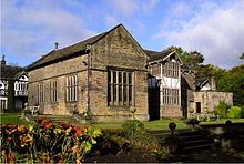 | Smithills Hall Smithills Hall is a Grade I listed manor house in Smithills, Bolton, Greater Manchester. It stands on the slopes of the West Pennine Moors above Bolton at a height of 500 feet. It occupies a defensive site near the Astley and Raveden Brooks. |
Visit Egerton, Greater Manchester plaques
 1
1
plaques
here Egerton, Greater Manchester has 1 physical plaques in tourist plaque schemes for you to explore via Walkfo Egerton, Greater Manchester plaques audio map when visiting. Plaques like National Heritage’s “Blue Plaques” provide visual geo-markers to highlight points-of-interest at the places where they happened – and Walkfo’s AI has researched additional, deeper content when you visit Egerton, Greater Manchester using the app. Experience the history of a location when Walkfo local tourist guide app triggers audio close to each Egerton, Greater Manchester plaque. Explore Plaques & History has a complete list of Hartlepool’s plaques & Hartlepool history plaque map.


 Trying to encourage visitors to Egerton, Greater Manchester?