Welcome to Visit Earls Colne Places
The Walkfo guide to things to do & explore in Earls Colne
 Visit Earls Colne places using Walkfo for free guided tours of the best Earls Colne places to visit. A unique way to experience Earls Colne’s places, Walkfo allows you to explore Earls Colne as you would a museum or art gallery with audio guides.
Visiting Earls Colne Walkfo Preview
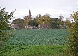
Earls Colne is a village in Essex named after the River Colne, on which it stands, and the Earls of Oxford who held the manor from before 1086 to 1703. When you visit Earls Colne, Walkfo brings Earls Colne places to life as you travel by foot, bike, bus or car with a mobile phone & headphones.
Earls Colne Places Overview: History, Culture & Facts about Earls Colne
Visit Earls Colne – Walkfo’s stats for the places to visit
With 15 audio plaques & Earls Colne places for you to explore in the Earls Colne area, Walkfo is the world’s largest heritage & history digital plaque provider. The AI continually learns & refines facts about the best Earls Colne places to visit from travel & tourism authorities (like Wikipedia), converting history into an interactive audio experience.
Earls Colne history
Manor of Earls Colne
In the time of Edward the Confessor Earls Colne belonged to a Saxon noble named Wulfwine also recorded as Ulwin/Ulwine. Ulwin’s whole estate was given to Aubrey de Vere by William the Conqueror. The Earls had an ancient mansion called Hall Place near the site of the present Ashwells in Park Lane.
Village records
Earls Colne is one of the best recorded villages in the UK. It has been the subject of a study undertaken between 1972 and 2002 by Professor Alan Macfarlane and his team from the University of Cambridge. The resulting database contains a large part of the surviving records of the parish over the period 1380–1854.
R. Hunt and Company Limited – Atlas Works

In 1824 Robert Hunt set up a millwrighting and wheelwrighting shop and smithy in Earls Colne, Cambridgeshire. The Atlas Works became the major employer in the village by 1900 employing approximately half of the male working population of the village. After exhibiting at the Royal Agricultural Show in 1851 the company’s products gained a country-wide recognition.
Earls Colne Industrial Co-operative Society

The Earls Colne Co-op was one of the last remaining independent village co-operative societies in Essex and Suffolk. It was founded in 1884 in the front room of a cottage in High Street. The current store occupies a building dating to between 1480 and 1510.
Earls Colne landmarks
The Earls Colne Heritage Museum occupies The Old Water Tower, Reuben Hunt Walk which was the former water tower of the Atlas Works, the home of R Hunt & Company. The main sections of the permanent exhibition comprise the Domesday Book, Colne Priory, The 1598 Map by Israel Amyce, The Diary of the Reverend Ralph Josselin, The Victorian Era, The Atlas Works and the Hunt Family.
Why visit Earls Colne with Walkfo Travel Guide App?
 You can visit Earls Colne places with Walkfo Earls Colne to hear history at Earls Colne’s places whilst walking around using the free digital tour app. Walkfo Earls Colne has 15 places to visit in our interactive Earls Colne map, with amazing history, culture & travel facts you can explore the same way you would at a museum or art gallery with information audio headset. With Walkfo, you can travel by foot, bike or bus throughout Earls Colne, being in the moment, without digital distraction or limits to a specific walking route. Our historic audio walks, National Trust interactive audio experiences, digital tour guides for English Heritage locations are available at Earls Colne places, with a AI tour guide to help you get the best from a visit to Earls Colne & the surrounding areas.
“Curated content for millions of locations across the UK, with 15 audio facts unique to Earls Colne places in an interactive Earls Colne map you can explore.”
Walkfo: Visit Earls Colne Places Map
15 tourist, history, culture & geography spots
Earls Colne historic spots | Earls Colne tourist destinations | Earls Colne plaques | Earls Colne geographic features |
| Walkfo Earls Colne tourism map key: places to see & visit like National Trust sites, Blue Plaques, English Heritage locations & top tourist destinations in Earls Colne | |||
Best Earls Colne places to visit
Earls Colne has places to explore by foot, bike or bus. Below are a selection of the varied Earls Colne’s destinations you can visit with additional content available at the Walkfo Earls Colne’s information audio spots:
 | Marks Hall Marks Hall was a Jacobean country house some 2 miles (3.2 km) north of Coggeshall in Essex. Previously a timber manor house, the 17th-century brick building was demolished in 1950. |
 | Greenstead Green and Halstead Rural Greenstead Green and Halstead Rural is a civil parish in the Braintree district, in the county of Essex, England. The parish includes the village of Greenstead Green, the hamlet of Burton’s Green, Plaistow Green and Whiteash Green. In 2011 the parish had a population of 670. |
Visit Earls Colne plaques
 0
0
plaques
here Earls Colne has 0 physical plaques in tourist plaque schemes for you to explore via Walkfo Earls Colne plaques audio map when visiting. Plaques like National Heritage’s “Blue Plaques” provide visual geo-markers to highlight points-of-interest at the places where they happened – and Walkfo’s AI has researched additional, deeper content when you visit Earls Colne using the app. Experience the history of a location when Walkfo local tourist guide app triggers audio close to each Earls Colne plaque. Currently No Physical Plaques.


 Trying to encourage visitors to Earls Colne?