Welcome to Visit Dublin Places
The Walkfo guide to things to do & explore in Dublin
 Visit Dublin places using Walkfo for free guided tours of the best Dublin places to visit. A unique way to experience Dublin’s places, Walkfo allows you to explore Dublin as you would a museum or art gallery with audio guides.
Visiting Dublin Walkfo Preview
Dublin is the capital and largest city of Ireland. Situated on a bay on the east coast, at the mouth of the River Liffey, it lies within the province of Leinster. It has an urban area population of 1,173,179, while the population of the Dublin Region (formerly County Dublin) as of 2016 was 1,347,359. It is bordered on the south by the Dublin Mountains, a part of the Wicklow Mountains. When you visit Dublin, Walkfo brings Dublin places to life as you travel by foot, bike, bus or car with a mobile phone & headphones.
Dublin Places Overview: History, Culture & Facts about Dublin
Visit Dublin – Walkfo’s stats for the places to visit
With 469 audio plaques & Dublin places for you to explore in the Dublin area, Walkfo is the world’s largest heritage & history digital plaque provider. The AI continually learns & refines facts about the best Dublin places to visit from travel & tourism authorities (like Wikipedia), converting history into an interactive audio experience.
Dublin history
The area of Dublin Bay has been inhabited by humans since prehistoric times. It is thought the Viking settlement of about 841 was preceded by a Christian ecclesiastical settlement known as Duibhlinn. The subsequent Scandinavian settlement centred on the River Poddle, a tributary of the Liffey in an area now known as Wood Quay.
Middle Ages
Dublin was established as a Viking settlement in the 10th century. It remained largely under Viking control until the Norman invasion of Ireland was launched from Wales in 1169. The Tudor conquest of Ireland in the 16th century spelt a new era for Dublin, with the city enjoying a renewed prominence as the centre of administrative rule.
Early modern

Georgian Dublin became the second largest city of the British Empire and the fifth largest city in Europe. The Wide Streets Commission was established in 1757 at the request of Dublin Corporation to govern architectural standards on the layout of streets, bridges and buildings. In 1759, the Guinness brewery was founded; and would eventually grow to become the largest brewery in the world and largest employer in Dublin.
Late modern and contemporary
Dublin suffered a period of political and economic decline during the 19th century following the Acts of Union 1800. The Easter Rising of 1916, the Irish War of Independence, and the subsequent Irish Civil War resulted in a significant amount of physical destruction in central Dublin. The city was at the forefront of Ireland’s economic expansion during the Celtic Tiger period, with private sector and state development of housing, transport and business.
Dublin culture & places
The arts
Dublin was named as a UNESCO City of Literature in July 2010. William Butler Yeats, George Bernard Shaw and Samuel Beckett are prominent writers and playwrights. Handel’s oratorio Messiah was first performed at Neal’s Music Hall, in Fishamble Street, on 13 April 1742. Ireland’s biggest libraries and literary museums are located in Dublin.
Entertainment
Dublin has a vibrant nightlife and is reputedly one of Europe’s most youthful cities. The area around Temple Bar, south of the River Liffey, is popular with stag and hen parties. The areas around Leeson Street, Harcourt Street, South William Street and Camden/George’s Street are popular nightlife spots.
Music
Live music is played on streets and at venues throughout Dublin. The city has produced several musicians and groups of international success. The Dubliners, Thin Lizzy, The Boomtown Rats, U2, The Script, Sinéad O’Connor, Boyzone, Kodaline, Fontaines D.C. and Westlife.
Shopping

Dublin city centre is a popular shopping destination for locals and tourists. The city centre has numerous shopping districts, particularly around Grafton Street and Henry Street. Suburban Dublin has several modern retail centres, including Dundrum Town Centre, Blanchardstown and the Square in Tallaght.
Media
Dublin is the centre of both media and communications in Ireland. Many newspapers, radio stations, television stations and telephone companies are based in the city. RTÉ is Ireland’s national state broadcaster, and is based in Donnybrook.
Sport

County Dublin is home for 13 of the senior rugby union clubs in Ireland including 5 of the 10 sides in the top division 1A. County Dublin has two ODI cricket grounds in Castle Avenue and Malahide Cricket Club Ground. The Dublin area hosts greyhound racing at Shelbourne Park and horse racing at Leopardstown.
Cuisine
As of the 2018 Michelin Guide, five Dublin restaurants shared six Michelin stars. Irish-owned coffee chains like Java Republic, Insomnia, and O’Brien’s Sandwich Bars now compete internationally. In 2008, Irish barista Stephen Morrissey won the title of World Barista Champion.
Dublin etymology
The name Dublin derives from the Irish word Dubhlinn, early Classical Irish Dubhlind/Duibhlind, from dubh meaning “black, dark”, and lind meaning “pool”, referring to a dark tidal pool. In Modern Irish the name is Duibhlininn, and Irish rhymes from County Dublin show that in Dublin Leinster Irish it was pronounced Duílinn [ˈd̪ˠiˉiːlʲiɲ]. The original pronunciation is preserved in the names for the city in other languages such as Old English Difelin, Old Norse Dyflin, Icelandic Dyflinn and modern Manx Divlyn.
Dublin geography / climate
Landscape

Dublin is situated at the mouth of the River Liffey and encompasses a land area of approximately 117.8 square kilometres (45.5 sq mi) It is bordered by the Dublin Mountains, a low mountain range and sub range of the Wicklow Mountains, to the south and surrounded by flat farmland to the north and west. Two secondary rivers further divide the city – the River Tolka, running southeast into Dublin Bay, and the River Dodder.
Cultural divide
A north–south division once, to some extent, traditionally existed, with the River Liffey as the divider. The Southside was, in recent times, generally seen as being more affluent and genteel than the Northside. In some tourism and real-estate marketing contexts, inner Dublin is sometimes divided into a number of “quarters” or districts.
Climate
Dublin experiences a maritime climate (Cfb) with mild-warm summers, cool winters, and a lack of temperature extremes. On average, the sunniest months are May and June, while the wettest month is October with 76 mm (3 in) of rain. Ringsend in the south of the city records the lowest rainfall in the country, with an average annual precipitation of 683 mm (27 in) The city centre is the driest place in Ireland, receiving only about half the rainfall of the west coast.
Why visit Dublin with Walkfo Travel Guide App?
 You can visit Dublin places with Walkfo Dublin to hear history at Dublin’s places whilst walking around using the free digital tour app. Walkfo Dublin has 469 places to visit in our interactive Dublin map, with amazing history, culture & travel facts you can explore the same way you would at a museum or art gallery with information audio headset. With Walkfo, you can travel by foot, bike or bus throughout Dublin, being in the moment, without digital distraction or limits to a specific walking route. Our historic audio walks, National Trust interactive audio experiences, digital tour guides for English Heritage locations are available at Dublin places, with a AI tour guide to help you get the best from a visit to Dublin & the surrounding areas.
“Curated content for millions of locations across the UK, with 469 audio facts unique to Dublin places in an interactive Dublin map you can explore.”
Walkfo: Visit Dublin Places Map
469 tourist, history, culture & geography spots
Dublin historic spots | Dublin tourist destinations | Dublin plaques | Dublin geographic features |
| Walkfo Dublin tourism map key: places to see & visit like National Trust sites, Blue Plaques, English Heritage locations & top tourist destinations in Dublin | |||
Best Dublin places to visit
Dublin has places to explore by foot, bike or bus. Below are a selection of the varied Dublin’s destinations you can visit with additional content available at the Walkfo Dublin’s information audio spots:

Gardiner Street
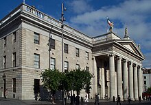
Gardiner Street was laid out in the 1790s by Luke Gardiner, 1st Viscount Mountjoy. It stretches from the River Liffey at its southern end via Mountjoy Square to Dorset Street at its northern end. The Custom House terminates the vista at the southern end.

Scots Presbyterian Church, Dublin
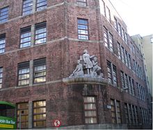
The Scots Presbyterian Church is a ruined former church on Seán McDermott Street in Dublin 1, Ireland. The church was designed in a Greek revival style by Duncan Campbell Ferguson and completed in 1846. The building operated as a Presbyterian church from 1846 until 1888 when the congregation was subsumed by the nearby Clontarf and Scots Presbyterian.
Cathal Brugha Street
Cathal Brugha Street is a street on the northside of Dublin, Ireland. It is located in the north of Dublin. It was the birthplace of Cathal Brugha, a native of the Roman Catholic religion.

An Bord Pleanála
An Bord Pleanála (ABP) is an independent, statutory, quasi-judicial body that decides on appeals from planning decisions made by local authorities in the Republic of Ireland. The Board also hears applications from local authorities for projects which would have a significant environmental impact.
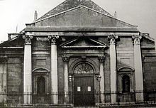
St. Thomas’s Church (old), Dublin
St Thomas’s Church in Marlborough Street, Dublin was a Church of Ireland parish church. It was replaced by a new church in 1930.

North Great George’s Street
North Great George’s Street (Irish: Sráid Mór Seóirse Thuaidh) is a street on the Northside of Dublin city first laid out in 1766. It consists of opposing terraces of 4 storey over basement red-brick Georgian townhouses descending on an increasingly steep gradient from Belvedere House.

St Mary’s Pro-Cathedral
St Mary’s Church (Irish: Leas-Ardeaglais Naomh Muire) is the episcopal seat of the Roman Catholic Archbishop of Dublin and Primate of Ireland.

Talbot Mall
Talbot Mall is a small shopping arcade located between Talbot Street, Northumberland Square, and Abbey Street. It was formerly known as Irish Life Mall and later Irish Life Shopping Mall prior to a 2013 rebranding.
![]()
Gate Theatre
The Gate Theatre is a theatre on Cavendish Row in Dublin, Ireland. It was founded in 1928 and Selina Cartmell has served as Artistic Director since April 2017.

Parnell Street
Parnell Street (Irish: Sráid Pharnell) is located on Dublin’s Northside. It runs from Capel Street in the west to Gardiner Street and Mountjoy Square in the east. It is at the north end of O’Connell Street, where it provides the south side of Parnell Square.
Visit Dublin plaques
 0
0
plaques
here Dublin has 0 physical plaques in tourist plaque schemes for you to explore via Walkfo Dublin plaques audio map when visiting. Plaques like National Heritage’s “Blue Plaques” provide visual geo-markers to highlight points-of-interest at the places where they happened – and Walkfo’s AI has researched additional, deeper content when you visit Dublin using the app. Experience the history of a location when Walkfo local tourist guide app triggers audio close to each Dublin plaque. Currently No Physical Plaques.


 Trying to encourage visitors to Dublin?