Welcome to Visit Drumburgh Places
The Walkfo guide to things to do & explore in Drumburgh
 Visit Drumburgh places using Walkfo for free guided tours of the best Drumburgh places to visit. A unique way to experience Drumburgh’s places, Walkfo allows you to explore Drumburgh as you would a museum or art gallery with audio guides.
Visiting Drumburgh Walkfo Preview
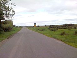
Drumburgh is 13 kilometres (8 mi) northwest of Carlisle and is on the course of Hadrian’s Wall. The village is sited on a gentle hill with a good view in all directions over the surrounding lowlands. When you visit Drumburgh, Walkfo brings Drumburgh places to life as you travel by foot, bike, bus or car with a mobile phone & headphones.
Drumburgh Places Overview: History, Culture & Facts about Drumburgh
Visit Drumburgh – Walkfo’s stats for the places to visit
With 16 audio plaques & Drumburgh places for you to explore in the Drumburgh area, Walkfo is the world’s largest heritage & history digital plaque provider. The AI continually learns & refines facts about the best Drumburgh places to visit from travel & tourism authorities (like Wikipedia), converting history into an interactive audio experience.
Drumburgh history
Coggabata is the Roman fort referred to in the placename. It was linked by a Roman road to the nearby fort at Kirkbride to the southwest. The name means ‘ridge near the fort’ as derived from the Celtic language and the common Old English word ‘burgh’
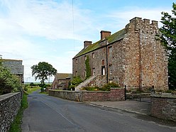
Drumburgh Castle

In the 14th century a peel tower house known as Drumburgh Castle was built here by Thomas, Lord Dacre. Licence to crenellate the preceding tower had been granted in 1307 to Robert le Brun. It passed by marriage in the 15th century to Jacob Harington, but by 1480 it was ruinous. After a long period of neglect it was fully restored as a private dwelling in the 1970s.
Why visit Drumburgh with Walkfo Travel Guide App?
 You can visit Drumburgh places with Walkfo Drumburgh to hear history at Drumburgh’s places whilst walking around using the free digital tour app. Walkfo Drumburgh has 16 places to visit in our interactive Drumburgh map, with amazing history, culture & travel facts you can explore the same way you would at a museum or art gallery with information audio headset. With Walkfo, you can travel by foot, bike or bus throughout Drumburgh, being in the moment, without digital distraction or limits to a specific walking route. Our historic audio walks, National Trust interactive audio experiences, digital tour guides for English Heritage locations are available at Drumburgh places, with a AI tour guide to help you get the best from a visit to Drumburgh & the surrounding areas.
“Curated content for millions of locations across the UK, with 16 audio facts unique to Drumburgh places in an interactive Drumburgh map you can explore.”
Walkfo: Visit Drumburgh Places Map
16 tourist, history, culture & geography spots
Drumburgh historic spots | Drumburgh tourist destinations | Drumburgh plaques | Drumburgh geographic features |
| Walkfo Drumburgh tourism map key: places to see & visit like National Trust sites, Blue Plaques, English Heritage locations & top tourist destinations in Drumburgh | |||
Best Drumburgh places to visit
Drumburgh has places to explore by foot, bike or bus. Below are a selection of the varied Drumburgh’s destinations you can visit with additional content available at the Walkfo Drumburgh’s information audio spots:
 | Milecastle 78 Milecastle 78 (Kirkland) was one of a series of Milecastles or small fortlets built at intervals of approximately one Roman mile along Hadrian’s Wall (grid reference NY245613) |
 | Milecastle 77 Milecastle 77 (Raven Bank) was one of a series of Milecastles or small fortlets built at intervals of approximately one Roman mile along Hadrian’s Wall (grid reference NY25666068) |
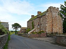 | Drumburgh Castle Drumburgh Castle is a medieval pele tower in Cumbria, England. The castle is located in the village of Drumbargh, in the north-west of the county. It was built in the 13th century. |
 | Coggabata Coggabata, or Congavata / Concavata, (with the modern name of Drumburgh) was a Roman fort on Hadrian’s Wall, between Aballava (Burgh by Sands) and Mais (Bowness-on-Solway) It was built on a hill commanding views over the flatter land to the east and west and to the shore of the Solway Firth to the north. Its purpose was to guard the southern end of two important Solway fords, the Stonewath and the Sandwath. |
 | Milecastle 76 Milecastle 76 (Drumburgh) was one of a series of Milecastles or small fortlets built at intervals of approximately one Roman mile along Hadrian’s Wall (grid reference NY26685987) |
 | Milecastle 74 Milecastle 74 (Burgh Marsh) was one of a series of milecastles or small fortlets built at intervals of approximately one Roman mile along Hadrian’s Wall (grid reference NY29575965) |
 | Milecastle 75 Milecastle 75 (Easton) was one of a series of Milecastles or small fortlets built at intervals of approximately one Roman mile along Hadrian’s Wall in England (grid reference NY28125975) |
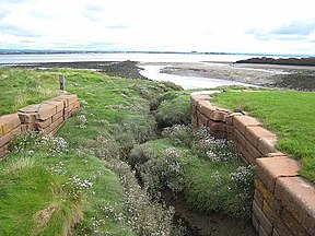 | Carlisle Canal The Carlisle Canal opened in 1823, to link Carlisle to the Solway Firth. It was a short-lived venture, being replaced by a railway in 1854. |
Visit Drumburgh plaques
 0
0
plaques
here Drumburgh has 0 physical plaques in tourist plaque schemes for you to explore via Walkfo Drumburgh plaques audio map when visiting. Plaques like National Heritage’s “Blue Plaques” provide visual geo-markers to highlight points-of-interest at the places where they happened – and Walkfo’s AI has researched additional, deeper content when you visit Drumburgh using the app. Experience the history of a location when Walkfo local tourist guide app triggers audio close to each Drumburgh plaque. Currently No Physical Plaques.


 Trying to encourage visitors to Drumburgh?