Welcome to Visit Drimpton Places
The Walkfo guide to things to do & explore in Drimpton
 Visit Drimpton places using Walkfo for free guided tours of the best Drimpton places to visit. A unique way to experience Drimpton’s places, Walkfo allows you to explore Drimpton as you would a museum or art gallery with audio guides.
Visiting Drimpton Walkfo Preview
Drimpton is situated 5 miles (8.0 km) northwest of Beaminster and 3.5 miles (5.6 km) southwest of Crewkerne in Somerset. Neighbouring settlements include Clapton, Seaborough, Blackdown, Kittwhistle, Burstock, Greenham and Netherhay. When you visit Drimpton, Walkfo brings Drimpton places to life as you travel by foot, bike, bus or car with a mobile phone & headphones.
Drimpton Places Overview: History, Culture & Facts about Drimpton
Visit Drimpton – Walkfo’s stats for the places to visit
With 20 audio plaques & Drimpton places for you to explore in the Drimpton area, Walkfo is the world’s largest heritage & history digital plaque provider. The AI continually learns & refines facts about the best Drimpton places to visit from travel & tourism authorities (like Wikipedia), converting history into an interactive audio experience.
Why visit Drimpton with Walkfo Travel Guide App?
 You can visit Drimpton places with Walkfo Drimpton to hear history at Drimpton’s places whilst walking around using the free digital tour app. Walkfo Drimpton has 20 places to visit in our interactive Drimpton map, with amazing history, culture & travel facts you can explore the same way you would at a museum or art gallery with information audio headset. With Walkfo, you can travel by foot, bike or bus throughout Drimpton, being in the moment, without digital distraction or limits to a specific walking route. Our historic audio walks, National Trust interactive audio experiences, digital tour guides for English Heritage locations are available at Drimpton places, with a AI tour guide to help you get the best from a visit to Drimpton & the surrounding areas.
“Curated content for millions of locations across the UK, with 20 audio facts unique to Drimpton places in an interactive Drimpton map you can explore.”
Walkfo: Visit Drimpton Places Map
20 tourist, history, culture & geography spots
Drimpton historic spots | Drimpton tourist destinations | Drimpton plaques | Drimpton geographic features |
| Walkfo Drimpton tourism map key: places to see & visit like National Trust sites, Blue Plaques, English Heritage locations & top tourist destinations in Drimpton | |||
Best Drimpton places to visit
Drimpton has places to explore by foot, bike or bus. Below are a selection of the varied Drimpton’s destinations you can visit with additional content available at the Walkfo Drimpton’s information audio spots:
 | Clapton Mill Clapton Mill is a former watermill located in West Crewkerne, Somerset. The existing mill dates back to the 18th century, but was extensively rebuilt in 1864. An earlier mill has existed on the same site since the 13th century. |
 | Church of St Michael, Wayford The Anglican Church of St Michael in Wayford, Somerset, was built in the 13th century. It is a Grade II* listed building. |
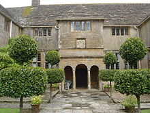 | Wayford Manor House Wayford Manor House is a country house with a garden in Britain, situated in Wayford, Somerset, England. It has been designated a Grade I listed building. |
 | St John’s Church, Seaborough St John’s Church is a Church of England church in Seaborough, Dorset. Much of the church dates to a rebuild of 1882 and it now forms part of the Beaminster Area Team Ministry. |
 | Holy Trinity Church, Blackdown Holy Trinity Church is a Church of England church in Blackdown, Dorset. It was designed by Edward Ledger Bracebridge and built in 1839–40. It now forms part of the Beaminster Area Team Ministry. |
 | Pilsdon Pen Pilsdon Pen is a 277-metre (909 ft) hill in Dorset in South West England. It is Dorset’s second highest point and has panoramic views extending for many miles. It was bequeathed to the National Trust by the Pinney family in 1982. |
 | Netherhay Methodist Chapel Netherhay Methodist Chapel is a Grade II listed building in West Dorset. The chapel was built with “dressed stone walls on a chert rubble-stone base” A burial ground was established alongside the chapel. |
 | West Bay Methodist Church Opened in 1849, the chapel was locally known as “the chapel on the beach” It closed in 2007 and was transformed into the West Bay Discovery Centre in 2018. |
 | St Mary’s Church, Drimpton St. Mary’s Church is a Church of England church in Drimpton, West Dorset. The church opened in 1867 and now forms part of the Beaminster Area Team Ministry. |
 | St Mary’s Church, Mosterton St Mary’s Church is a Church of England parish church in Mosterton, Dorset. It was designed by Edmund Pearce and built in 1832–33 to replace an earlier building. The church is now part of the Beaminster Area Team Ministry and is Grade II listed. |
Visit Drimpton plaques
 0
0
plaques
here Drimpton has 0 physical plaques in tourist plaque schemes for you to explore via Walkfo Drimpton plaques audio map when visiting. Plaques like National Heritage’s “Blue Plaques” provide visual geo-markers to highlight points-of-interest at the places where they happened – and Walkfo’s AI has researched additional, deeper content when you visit Drimpton using the app. Experience the history of a location when Walkfo local tourist guide app triggers audio close to each Drimpton plaque. Currently No Physical Plaques.


 Trying to encourage visitors to Drimpton?