Welcome to Visit Drayton, Cherwell Places The Walkfo guide to things to do & explore in Drayton, Cherwell
Visit Drayton, Cherwell places using Walkfo for free guided tours of the best Drayton, Cherwell places to visit. A unique way to experience Drayton, Cherwell’s places, Walkfo allows you to explore Drayton, Cherwell as you would a museum or art gallery with audio guides.
Visiting Drayton, Cherwell Walkfo Preview When you visit Drayton, Cherwell, Walkfo brings Drayton, Cherwell places to life as you travel by foot, bike, bus or car with a mobile phone & headphones.
Visit Drayton, Cherwell – Walkfo’s stats for the places to visit
With 33 audio plaques & Drayton, Cherwell places for you to explore in the Drayton, Cherwell area, Walkfo is the world’s largest heritage & history digital plaque provider. The AI continually learns & refines facts about the best Drayton, Cherwell places to visit from travel & tourism authorities (like Wikipedia), converting history into an interactive audio experience.
Why visit Drayton, Cherwell with Walkfo Travel Guide App?
You can visit Drayton, Cherwell places with Walkfo Drayton, Cherwell to hear history at Drayton, Cherwell’s places whilst walking around using the free digital tour app. Walkfo Drayton, Cherwell has 33 places to visit in our interactive Drayton, Cherwell map, with amazing history, culture & travel facts you can explore the same way you would at a museum or art gallery with information audio headset. With Walkfo, you can travel by foot, bike or bus throughout Drayton, Cherwell, being in the moment, without digital distraction or limits to a specific walking route. Our historic audio walks, National Trust interactive audio experiences, digital tour guides for English Heritage locations are available at Drayton, Cherwell places, with a AI tour guide to help you get the best from a visit to Drayton, Cherwell & the surrounding areas.
“Curated content for millions of locations across the UK, with 33 audio facts unique to Drayton, Cherwell places in an interactive Drayton, Cherwell map you can explore.”
Walkfo Drayton, Cherwell tourism map key: places to see & visit like National Trust sites, Blue Plaques, English Heritage locations & top tourist destinations in Drayton, Cherwell
Best Drayton, Cherwell places to visit
Drayton, Cherwell has places to explore by foot, bike or bus. Below are a selection of the varied Drayton, Cherwell’s destinations you can visit with additional content available at the Walkfo Drayton, Cherwell’s information audio spots:
Wroxton Abbey Jacobean house is 2.5 miles (4 km) west of Banbury, off the A422 road in Wroxton . It is now the English campus of Fairleigh Dickinson University in New Jersey .
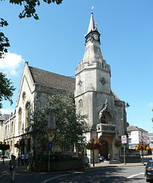
Banbury Town Hall Banbury Town Hall is a municipal facility in the High Street in Banbury, Oxfordshire. It was the headquarters of Banbury Borough Council from its completion in 1854 until 1930. The town hall is a Grade II listed building.
Hunt Edmunds Hunt Edmunds was a brewery in Banbury, Oxfordshire, England. It was established in the 1930s. It is located in the area of Banbury in Oxfordshire.
Banbury Lido The Woodgreen Lido at Woodgreen Leisure Centre, Banbury, Oxfordshire, is an open air lido. The lido is 50 metres long and 18 metres wide, meeting Olympic standards. The co-located leisure centre has an indoor sports hall, fitness gym and fitness studio.
Banbury United F.C. Banbury United Football Club is a football club based in Banbury, Oxfordshire, England. They are currently members of the Southern League Premier Division Central and play at the Spencer Stadium.
Horton General Hospital Horton General Hospital is a National Health Service hospital located on the Oxford Road, in the Calthorpe ward of Banbury. It is managed by Oxford University Hospitals NHS Foundation Trust.
Easington Sports F.C. Easington Sports Football Club is an amateur football club based in Banbury, Oxfordshire. They are currently members of the United Counties League Premier Division South and play at Addison Road.
Neithrop Neithrop is an inner housing estate and part of the greater ‘Neithrop ward’ of Banbury, Oxfordshire, England. It is one of the oldest areas in Banbury having first been first recorded as a hamlet in the 13th century.
Visit Drayton, Cherwell plaques
11 plaques hereDrayton, Cherwell has 11 physical plaques in tourist plaque schemes for you to explore via Walkfo Drayton, Cherwell plaques audio map when visiting. Plaques like National Heritage’s “Blue Plaques” provide visual geo-markers to highlight points-of-interest at the places where they happened – and Walkfo’s AI has researched additional, deeper content when you visit Drayton, Cherwell using the app. Experience the history of a location when Walkfo local tourist guide app triggers audio close to each Drayton, Cherwell plaque. Explore Plaques & History has a complete list of Hartlepool’s plaques & Hartlepool history plaque map.
Experience Drayton, Cherwell audio walks & tours
Walkfo guides for things to do / places to visit in Drayton, Cherwell allows exploration as you would do an art gallery or museum. Walk close to one of Drayton, Cherwell’s 33 historic places & our digital tour guide will create an audio story for that spot. With headphone connected, you can explore Drayton, Cherwell freely by foot, bike or bus – with your own personal tour guide in your pocket.
Explore Drayton, Cherwell Map App
Our visit Drayton, Cherwell map shows you things-to-do & places you can visit in Drayton, Cherwell & surrounding areas using the Walkfo digital audio tour guide app. Each spot has plaque, building, street or area information on history, culture or tourism.
You can set your Walkfo’s Drayton, Cherwell tourist map to find historic & tourism spots within 1km, 3km & 5km of the Drayton, Cherwell centre, depending on how far you plan to explore whilst you visit Drayton, Cherwell area at LONG:-1.375, LAT:52.072.
Walkfo App
Walkfo
Walkfo is free to download & use (for a limited time period), so if you are looking to explore Drayton, Cherwell, go to your App Store to search for “Walkfo” or follow a links below and install on your mobile phone. Walkfo is designed for use with headphones or AirPods, so you can walk & explore whilst learning about the things around you without digital distraction.
Getting to / around Drayton, Cherwell – transport link, station & street map
Getting around in Drayton, Cherwell using public transportation may include road, street, train, underground, bus or tram transport options. Walkfo has identified the following Drayton, Cherwell places with historic / cultural / factual content when you visit:
Local Drayton, Cherwell historians & Drayton, Cherwell tour guides
Trying to encourage visitors to Drayton, Cherwell? Walkfo has millions audio places already available but Walkfo Creator gives Drayton, Cherwell’s places, attractions & landmarks ability to create their own unique outdoor audio museums & using our simple & easy to use Walkfo Creator. – Creating a new audio experience for your Drayton, Cherwell place is free* and quick (15+ minutes if you prepare text content) to use, with Walkfo Creator doing the hard work of generating AI audio files for geo-spots from the text you provide with a simply click on a map. – The 100 Amazing Drayton, Cherwell Places is just one example of an outdoor museum created using Walkfo Creator (pictured to the left) for people to safely explore during Covid-19 times whilst visiting a city. Our tool is open to tourism organisations, travel destinations & National Trust locations to create their own audio walks to offer free when people visit Drayton, Cherwell destinations. – Walkfo itself is looking to partner with websites offering things-to-do / what’s on events listings to enhance the content of our ‘visit-Drayton, Cherwell’ web pages (for example: www.visitDrayton, Cherwell.com). If you are interested in partnering, please contact us to discuss options.
* Walkfo Creator is free to use for a limited number of audio spots within a map with a license fee applicable when more than 20 audio spots within location walk are created. v1.1336
 Visit Drayton, Cherwell places using Walkfo for free guided tours of the best Drayton, Cherwell places to visit. A unique way to experience Drayton, Cherwell’s places, Walkfo allows you to explore Drayton, Cherwell as you would a museum or art gallery with audio guides.
 You can visit Drayton, Cherwell places with Walkfo Drayton, Cherwell to hear history at Drayton, Cherwell’s places whilst walking around using the free digital tour app. Walkfo Drayton, Cherwell has 33 places to visit in our interactive Drayton, Cherwell map, with amazing history, culture & travel facts you can explore the same way you would at a museum or art gallery with information audio headset. With Walkfo, you can travel by foot, bike or bus throughout Drayton, Cherwell, being in the moment, without digital distraction or limits to a specific walking route. Our historic audio walks, National Trust interactive audio experiences, digital tour guides for English Heritage locations are available at Drayton, Cherwell places, with a AI tour guide to help you get the best from a visit to Drayton, Cherwell & the surrounding areas.


 11
11


 Trying to encourage visitors to Drayton, Cherwell?