Welcome to Visit Dormansland, Surrey Places
The Walkfo guide to things to do & explore in Dormansland, Surrey
 Visit Dormansland, Surrey places using Walkfo for free guided tours of the best Dormansland, Surrey places to visit. A unique way to experience Dormansland, Surrey’s places, Walkfo allows you to explore Dormansland, Surrey as you would a museum or art gallery with audio guides.
Visiting Dormansland, Surrey Walkfo Preview
Dormansland is a large village and civil parish with a low population. It was founded in the 19th century and is one mile south of Lingfield in Surrey. It is bordered on the east by the county of Kent and on the south by West Sussex and East Sussex. When you visit Dormansland, Surrey, Walkfo brings Dormansland, Surrey places to life as you travel by foot, bike, bus or car with a mobile phone & headphones.
Dormansland, Surrey Places Overview: History, Culture & Facts about Dormansland, Surrey
Visit Dormansland, Surrey – Walkfo’s stats for the places to visit
With 15 audio plaques & Dormansland, Surrey places for you to explore in the Dormansland, Surrey area, Walkfo is the world’s largest heritage & history digital plaque provider. The AI continually learns & refines facts about the best Dormansland, Surrey places to visit from travel & tourism authorities (like Wikipedia), converting history into an interactive audio experience.
Dormansland, Surrey history
The earliest known settlement in the parish was at Dry Hill, dating from approximately 500BC. The east of the parish includes a large, partly farmed ‘park and garden’ around a listed building (at Grade II architecturally), Greathed Manor, built as Ford House in 1862. A Baptist Chapel was built in 1796, and a National School in 1851.
Dormansland, Surrey geography / climate
Dormansland is a rural and semi-rural village of a largely cleared, flat area of the Weald save for the woodlands covering most of Greathed’s private park. The Prime Meridian passes through the parish, just west of its centre. Dry Hill, 172 metres above sea level, is the 19th highest hill in Surrey.
Why visit Dormansland, Surrey with Walkfo Travel Guide App?
 You can visit Dormansland, Surrey places with Walkfo Dormansland, Surrey to hear history at Dormansland, Surrey’s places whilst walking around using the free digital tour app. Walkfo Dormansland, Surrey has 15 places to visit in our interactive Dormansland, Surrey map, with amazing history, culture & travel facts you can explore the same way you would at a museum or art gallery with information audio headset. With Walkfo, you can travel by foot, bike or bus throughout Dormansland, Surrey, being in the moment, without digital distraction or limits to a specific walking route. Our historic audio walks, National Trust interactive audio experiences, digital tour guides for English Heritage locations are available at Dormansland, Surrey places, with a AI tour guide to help you get the best from a visit to Dormansland, Surrey & the surrounding areas.
“Curated content for millions of locations across the UK, with 15 audio facts unique to Dormansland, Surrey places in an interactive Dormansland, Surrey map you can explore.”
Walkfo: Visit Dormansland, Surrey Places Map
15 tourist, history, culture & geography spots
Dormansland, Surrey historic spots | Dormansland, Surrey tourist destinations | Dormansland, Surrey plaques | Dormansland, Surrey geographic features |
| Walkfo Dormansland, Surrey tourism map key: places to see & visit like National Trust sites, Blue Plaques, English Heritage locations & top tourist destinations in Dormansland, Surrey | |||
Best Dormansland, Surrey places to visit
Dormansland, Surrey has places to explore by foot, bike or bus. Below are a selection of the varied Dormansland, Surrey’s destinations you can visit with additional content available at the Walkfo Dormansland, Surrey’s information audio spots:
![]()
East Grinstead Town F.C.
East Grinstead Town Football Club is a football club based in West Sussex, England . They are currently members of the Isthmian League South East Division and play at East Court .

Haxted Watermill
Haxted Watermill is a much-restored Grade II listed watermill in Surrey, England. It is powered by the River Eden, close to the border with Kent.

Starborough Castle
Neo-Gothic garden house was built in 1754 by Sir James Burrow. It occupies the north-eastern portion of an artificial island south of the River Eden, roughly 3 km (2 mi) to the south-west of Edenbridge.
![]()
Lingfield F.C.
Lingfield Football Club are a football club based in Lingfield, near East Grinstead, Surrey, England. The club is affiliated to the Surrey County Football Association. They are currently members of the Southern Combination Premier Division.

Greathed Manor
Greathed Manor, Dormansland, Surrey, is a Victorian country house. Designed by the architect Robert Kerr in 1862–8, it is a Grade II listed building.
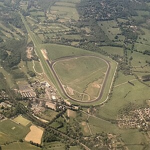
Lingfield Park Racecourse
Lingfield Park Racecourse is a horse racing course at Lingfield in Surrey, United Kingdom. It is owned by ARC Racing and Leisure Group, formerly Arena Leisure Plc. Lingfield is best known as a winter all-weather flat-racing course; the track is Polytrack, rather than the usual turf found in the UK.
Visit Dormansland, Surrey plaques
 0
0
plaques
here Dormansland, Surrey has 0 physical plaques in tourist plaque schemes for you to explore via Walkfo Dormansland, Surrey plaques audio map when visiting. Plaques like National Heritage’s “Blue Plaques” provide visual geo-markers to highlight points-of-interest at the places where they happened – and Walkfo’s AI has researched additional, deeper content when you visit Dormansland, Surrey using the app. Experience the history of a location when Walkfo local tourist guide app triggers audio close to each Dormansland, Surrey plaque. Currently No Physical Plaques.


 Trying to encourage visitors to Dormansland, Surrey?