Welcome to Visit Donisthorpe Places
The Walkfo guide to things to do & explore in Donisthorpe
 Visit Donisthorpe places using Walkfo for free guided tours of the best Donisthorpe places to visit. A unique way to experience Donisthorpe’s places, Walkfo allows you to explore Donisthorpe as you would a museum or art gallery with audio guides.
Visiting Donisthorpe Walkfo Preview
Donisthorpe is a village in the North West Leicestershire district. It was historically an exclave of Derbyshire. When you visit Donisthorpe, Walkfo brings Donisthorpe places to life as you travel by foot, bike, bus or car with a mobile phone & headphones.
Donisthorpe Places Overview: History, Culture & Facts about Donisthorpe
Visit Donisthorpe – Walkfo’s stats for the places to visit
With 19 audio plaques & Donisthorpe places for you to explore in the Donisthorpe area, Walkfo is the world’s largest heritage & history digital plaque provider. The AI continually learns & refines facts about the best Donisthorpe places to visit from travel & tourism authorities (like Wikipedia), converting history into an interactive audio experience.
Donisthorpe history
In 1086 Donisthorpe was part of the land given to Nigel of Stafford by William the Conqueror. It was then known as “Durandestorp” which has been interpreted as ‘the outlying settlement associated with Durand’. From: A Topographical Dictionary of England, published by S Lewis, London, 1848. DONISTHORPE, an ecclesiastical district, in the union of Ashby-de-la-Zouch, partly in the parish of Nether Seal, W. division of the hundred of Goscote, N. division of the county of Leicester, and partly in the parishes of Church-Gresley, Measham, and Stretton-en-le-Fields, hundred of Repton and Gresley, S. division of the county of Derby, 3½ miles (S. W.) from Ashby-de-la-Zouch; containing about 1700 inhabitants, of whom 344 are in the hamlet of Donisthorpe. The district includes Oakthorpe and Moira; the Moira baths are celebrated for the cure of rheumatism, and there is a convenient hotel for the accommodation of visiters. The living is a perpetual curacy, in the patronage of the Bishop of Lichfield; net income, £150, with a parsonage-house. The impropriate tithes of Donisthorpe have been commuted for £87. The church, dedicated to St. John, was built and endowed in 1838, at an expense of £6000, chiefly by three maiden ladies of the name of Moore; it is a neat edifice, with a tower and pinnacles. A national school was built in 1840, by Sir John Cave Browne Cave, Bart., by whom, also, it is supported From: Kelly’s Directory of Leicestershire & Rutland (1899) DONISTHORPE is a parish, formed in 1838, from the civil parishes of Church Gresley, Measham and Stretton-en-le-Field, and Ashby-de-la-Zouch and Seal, in Leicestershire, with a station on the Ashby and Nuneaton joint line of the Midland and London and North Western railways, 3 miles southwest from Ashby-de-la-Zouch, 8 southeast from Burton-upon-Trent and 114 northwest from London, in the Western division of the county, hundreds of Repton, Gresley and West Goscote, petty sessional division, union and county court district of Ashby-de-la-Zouch, rural deanery of Repton, archdeaconry of Derby and diocese of Southwell. Donisthorpe and Oakthorpe hamlets form a joint township in this ecclesiastical parish. This parish, formerly in Derbyshire, was transferred to Leicestershire under the provisions of the Local Government (England and Wales) Act, 1888, by the counties of Derby and Leicester (Woodville &c.) Order, which came into operation Sept. 30, 1897. The church of St John the Evangelist, erected in 1838, is a building of grey sandstone in the Perpendicular style, consisting of nave, west porch and an embattled western tower, with pinnacles, containing a clock and one bell: the nave was restored in 1889—90, and further restorations were effected in 1891, at a total cost of £700, and again in 1898: there are 500 sittings, 200 being free. The register dates from the year 1838. The living is a vicarage, net yearly value £214, including 17 acres of glebe, with residence, in the gift of the Bishop of Southwell, and held since 1885 by the Rev. Edward Bertram Lavies Theol. Assoc. K.C.L. Here are two Primitive Methodist chapels. A cemetery, containing 1 ½ acres was opened in 1875, and is under the control of the Parish Council of Oakthorpe and Donisthorpe and Urban District Council of Moira. There is a colliery, worked by Messrs. Checkland, Son and Williams, and the brewery of G. and W. F. Cooper. The principal landowners are the trustees of the late Lord Donington (d. 1895), Sir Mylles Cave-Brown-Cave bart. of Stretton-en-le-Field, the trustees of the late William Turner, Messrs. W. F. Cooper, S. Greaves, Drewry and some small freeholders. The soil is mixed; subsoil, chiefly clay. The chief crops are wheat, barley and oats. The area is 1,785 acres of land and 20 of water; rateable value, including Oakthorpe, £6,671; the population of the township in 1891 was 1,678, and of the parish 2,955. National School (mixed), erected in 1830, for 82 children; average attendance, 82. Wesleyan School (mixed), erected in 1875 & enlarged in 1894, for 142 children; average attendance, 130. A Primitive Methodist Chapel was built in 1852 and the Ordnance Survey map of 1884 shows one just north of the Engine Inn, the Mount Zion Chapel that was demolished in 2003. By 1908 there were two Primitive Methodist Chapels together with a Wesleyan chapel. Donisthorpe Colliery closed in 1991. When the pit was operating the village had two post offices, five public houses, and 14 shops including a Coop Store (now the Scout Centre), a VG store, two butchers, a baker, a general store, a betting shop and a chip shop. At the time of pit closure in 1991 Donisthorpe contained four local shops, and a post office. Today the village has one shop (opened in 2014), and two pubs. Donisthorpe Miners’ Welfare Centre closed during 2005, and since became a children’s fun centre. The former mine site was developed into a housing estate. The colliery site became the Donisthorpe Woodland Park. Further sites of former employment included a shoe factory and brickyard.
Donisthorpe landmarks

Donisthorpe and Moira with Stretton-en-le-Field in the Archdeaconry of Loughborough in the Diocese of Leicester. St John the Evangelist Church was erected in 1938. The last dedicated vicar vacated his position in 2006; the church is now part of a team ministry based in the nearby village of Measham.
Donisthorpe geography / climate
Donisthorpe is 3 miles (5 km) south-west of Ashby-de-la-Zouch, 3.5 miles south of Swadlincote and 1,000 yards (914 m) from the Derbyshire border. A former mining village, it is just under 4 miles (6 km) due east of Church Flatts Farm, the furthest point from coastal waters on the British mainland.
Why visit Donisthorpe with Walkfo Travel Guide App?
 You can visit Donisthorpe places with Walkfo Donisthorpe to hear history at Donisthorpe’s places whilst walking around using the free digital tour app. Walkfo Donisthorpe has 19 places to visit in our interactive Donisthorpe map, with amazing history, culture & travel facts you can explore the same way you would at a museum or art gallery with information audio headset. With Walkfo, you can travel by foot, bike or bus throughout Donisthorpe, being in the moment, without digital distraction or limits to a specific walking route. Our historic audio walks, National Trust interactive audio experiences, digital tour guides for English Heritage locations are available at Donisthorpe places, with a AI tour guide to help you get the best from a visit to Donisthorpe & the surrounding areas.
“Curated content for millions of locations across the UK, with 19 audio facts unique to Donisthorpe places in an interactive Donisthorpe map you can explore.”
Walkfo: Visit Donisthorpe Places Map
19 tourist, history, culture & geography spots
Donisthorpe historic spots | Donisthorpe tourist destinations | Donisthorpe plaques | Donisthorpe geographic features |
| Walkfo Donisthorpe tourism map key: places to see & visit like National Trust sites, Blue Plaques, English Heritage locations & top tourist destinations in Donisthorpe | |||
Best Donisthorpe places to visit
Donisthorpe has places to explore by foot, bike or bus. Below are a selection of the varied Donisthorpe’s destinations you can visit with additional content available at the Walkfo Donisthorpe’s information audio spots:
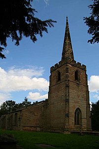
St Michael’s Church, Stretton en le Field
St Michael’s Church is a redundant Anglican church in the village of Stretton en le Field, Leicestershire, England (grid reference SK303119) It is recorded in the National Heritage List for England as a designated Grade II* listed building.

Moira Furnace
Moira Furnace is a nineteenth-century iron-making blast furnace located in Moira, Leicestershire, on the banks of the Ashby-de-la-Zouch Canal. Built by the Earl of Moira in 1804, the building has been preserved as a museum featuring lime kilns and craft workshops.

St Peter’s Church, Netherseal
St Peter’s Church is a Grade II* listed parish church in Netherseal, Derbyshire. It was built in the 1930s and is now a Grade I listed parish.
Visit Donisthorpe plaques
 0
0
plaques
here Donisthorpe has 0 physical plaques in tourist plaque schemes for you to explore via Walkfo Donisthorpe plaques audio map when visiting. Plaques like National Heritage’s “Blue Plaques” provide visual geo-markers to highlight points-of-interest at the places where they happened – and Walkfo’s AI has researched additional, deeper content when you visit Donisthorpe using the app. Experience the history of a location when Walkfo local tourist guide app triggers audio close to each Donisthorpe plaque. Currently No Physical Plaques.


 Trying to encourage visitors to Donisthorpe?