Welcome to Visit Ditchingham Places
The Walkfo guide to things to do & explore in Ditchingham
 Visit Ditchingham places using Walkfo for free guided tours of the best Ditchingham places to visit. A unique way to experience Ditchingham’s places, Walkfo allows you to explore Ditchingham as you would a museum or art gallery with audio guides.
Visiting Ditchingham Walkfo Preview
Ditchingham is a village and civil parish in the English county of Norfolk. It is located across the River Waveney from Bungay, Suffolk near The Broads National Park. The civil parish has an area of 8.56 km (3.31 sq mi) and in the 2001 census had a population of 1614. When you visit Ditchingham, Walkfo brings Ditchingham places to life as you travel by foot, bike, bus or car with a mobile phone & headphones.
Ditchingham Places Overview: History, Culture & Facts about Ditchingham
Visit Ditchingham – Walkfo’s stats for the places to visit
 With 19 audio plaques & Ditchingham places for you to explore in the Ditchingham area, Walkfo is the world’s largest heritage & history digital plaque provider. The AI continually learns & refines facts about the best Ditchingham places to visit from travel & tourism authorities (like Wikipedia), converting history into an interactive audio experience.
Ditchingham history
In the middle ages Ditchingham consisted of two manor manors. In the Domesday Book of 1086 the lord of the manor of Pirnhow was Roger Bigot. In 1855 Lavinia Crosse founded the Anglican Community of All Hallows. The novelist Sir H. Rider Haggard, author of King Solomon’s Mines, lived there.
Ditchingham toponymy
The villages name origin is uncertain but could mean ‘Homestead/village of the Dicingas (= the dwellers at the ditch)’ or perhaps ‘homestead/Village of Dic(c)a’s people’
Why visit Ditchingham with Walkfo Travel Guide App?
 You can visit Ditchingham places with Walkfo Ditchingham to hear history at Ditchingham’s places whilst walking around using the free digital tour app. Walkfo Ditchingham has 19 places to visit in our interactive Ditchingham map, with amazing history, culture & travel facts you can explore the same way you would at a museum or art gallery with information audio headset. With Walkfo, you can travel by foot, bike or bus throughout Ditchingham, being in the moment, without digital distraction or limits to a specific walking route. Our historic audio walks, National Trust interactive audio experiences, digital tour guides for English Heritage locations are available at Ditchingham places, with a AI tour guide to help you get the best from a visit to Ditchingham & the surrounding areas.
“Curated content for millions of locations across the UK, with 19 audio facts unique to Ditchingham places in an interactive Ditchingham map you can explore.”
Walkfo: Visit Ditchingham Places Map
19 tourist, history, culture & geography spots
Ditchingham historic spots | Ditchingham tourist destinations | Ditchingham plaques | Ditchingham geographic features |
| Walkfo Ditchingham tourism map key: places to see & visit like National Trust sites, Blue Plaques, English Heritage locations & top tourist destinations in Ditchingham | |||
Best Ditchingham places to visit
Ditchingham has places to explore by foot, bike or bus. Below are a selection of the varied Ditchingham’s destinations you can visit with additional content available at the Walkfo Ditchingham’s information audio spots:

Bungay Castle
Bungay Castle is in the town of Bungay, Suffolk by the River Waveney . The castle is located in Bungay and is located by the river .
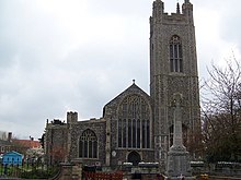
St Mary’s Church, Bungay
St Mary’s Church is a redundant Anglican church in the town of Bungay, Suffolk . The church and the ruins of the adjacent priory are recorded in the National Heritage List for England as a designated Grade I listed building .

Bungay Town F.C.
Bungay Town Football Club is a football club based in Bungay, Suffolk . The club are currently members of Anglian Combination Division One . They play at the Maltings Meadow Sports Ground .
Ditchingham
Ditchingham is a village and civil parish in the English county of Norfolk. It is located across the River Waveney from Bungay, Suffolk near The Broads National Park. The civil parish has an area of 8.56 km (3.31 sq mi) and in the 2001 census had a population of 1614.

Miners’ Welfare Park
Miners’ Welfare Park is the premier urban park in Bedworth, Warwickshire, England. It is located in the city’s largest urban park.

Ditchingham Hall
Ditchingham Hall is set in about 2,000 acres (810 ha) of parkland landscaped by Capability Brown. It is the country house of Earl Ferrers since it was inherited by the 13th Countess Ferrers. The current owner of the Hall is Robert William Saswalo Shirley, 14th Earl.
Visit Ditchingham plaques
 2
2
plaques
here Ditchingham has 2 physical plaques in tourist plaque schemes for you to explore via Walkfo Ditchingham plaques audio map when visiting. Plaques like National Heritage’s “Blue Plaques” provide visual geo-markers to highlight points-of-interest at the places where they happened – and Walkfo’s AI has researched additional, deeper content when you visit Ditchingham using the app. Experience the history of a location when Walkfo local tourist guide app triggers audio close to each Ditchingham plaque. Explore Plaques & History has a complete list of Hartlepool’s plaques & Hartlepool history plaque map.


 Trying to encourage visitors to Ditchingham?