Welcome to Visit Didsbury Places
The Walkfo guide to things to do & explore in Didsbury
 Visit Didsbury places using Walkfo for free guided tours of the best Didsbury places to visit. A unique way to experience Didsbury’s places, Walkfo allows you to explore Didsbury as you would a museum or art gallery with audio guides.
Visiting Didsbury Walkfo Preview
Didsbury is on the north bank of the River Mersey, 4+1/2 miles (7 kilometres) south of Manchester city centre. The population at the 2011 census was 26,788. There are records of a small hamlet as early as the 13th century. When you visit Didsbury, Walkfo brings Didsbury places to life as you travel by foot, bike, bus or car with a mobile phone & headphones.
Didsbury Places Overview: History, Culture & Facts about Didsbury
Visit Didsbury – Walkfo’s stats for the places to visit
With 117 audio plaques & Didsbury places for you to explore in the Didsbury area, Walkfo is the world’s largest heritage & history digital plaque provider. The AI continually learns & refines facts about the best Didsbury places to visit from travel & tourism authorities (like Wikipedia), converting history into an interactive audio experience.
Didsbury history
Toponymy
Didsbury derives its name from the Anglo-Saxon Dyddi’s burg. It was on a cliff overlooking a place where the River Mersey could be forded. In the 13th century it was variously referred to as Dydesbyre or Dodesbury.
Parish church

A charter granted in about 1260 shows that a corn-grinding mill was operating in Didsbury, along the River Mersey. The church was named St James Church in 1855 and underwent major refurbishment in 1620 and again in the 19th century. A parsonage was built next to one of the two public houses that flanked the nearby village green, Ye Olde Cock Inn, so-called because of the cockfighting that used to take place there.
River Mersey
Didsbury was one of the few places between Stretford and Stockport where the River Mersey could be forded. It made it significant for troop movements during the English Civil War, in which Manchester was on the Parliamentarian side.
Immigration from Europe
Jewish immigrants started to arrive in Manchester from the late 18th century. Growing population of German merchants and industrialists earned Manchester the nickname of “the German city” In the Didsbury area, the Souchays were a well-known merchant family of Huguenot descent with connections to Germany.
19th and 20th centuries

Didsbury developed as a prosperous settlement during the Victorian expansion of Manchester. The opening of the Manchester South District Line by the Midland Railway in 1880 contributed greatly to the rapid growth in the population of the area. In 1910, French pilot Louis Paulhan landed his Farman biplane in Barcicroft Fields, Pytha Fold Farm, on the borders of Withington, Burnage and Didbury, at the end of the first flight from London to Manchester.
Didsbury culture & places
The 200-year-old Peacock’s Funeral Parlour was demolished in 2005 to make way for Boots the Chemists. Traditional independent retailers are gradually being replaced by multi-national firms. However, independent traders continue to thrive, especially in West Didsbury.
Green areas
Fletcher Moss Botanical Garden is a 21-acre (8-hectare) recreational park south of the village centre. Fog Lane Park is a large municipal green space which borders on Withington and Burnage. Marie Louise Gardens is a relatively small park to the west of the centre of Didsbury, opened in 1903 in memory of Marie Louise Silkenstadt.
Didsbury geography / climate

Didsbury is south of the midpoint of the Greater Manchester Urban Area. It is 4+1/2 miles (7 kilometres) south of Manchester city centre. The River Mersey forms the area’s southern and southwestern boundaries. The area is roughly enclosed by Princess Parkway to the west, Kingsway to the east and Ball Brook to the north.
Why visit Didsbury with Walkfo Travel Guide App?
 You can visit Didsbury places with Walkfo Didsbury to hear history at Didsbury’s places whilst walking around using the free digital tour app. Walkfo Didsbury has 117 places to visit in our interactive Didsbury map, with amazing history, culture & travel facts you can explore the same way you would at a museum or art gallery with information audio headset. With Walkfo, you can travel by foot, bike or bus throughout Didsbury, being in the moment, without digital distraction or limits to a specific walking route. Our historic audio walks, National Trust interactive audio experiences, digital tour guides for English Heritage locations are available at Didsbury places, with a AI tour guide to help you get the best from a visit to Didsbury & the surrounding areas.
“Curated content for millions of locations across the UK, with 117 audio facts unique to Didsbury places in an interactive Didsbury map you can explore.”
Walkfo: Visit Didsbury Places Map
117 tourist, history, culture & geography spots
Didsbury historic spots | Didsbury tourist destinations | Didsbury plaques | Didsbury geographic features |
| Walkfo Didsbury tourism map key: places to see & visit like National Trust sites, Blue Plaques, English Heritage locations & top tourist destinations in Didsbury | |||
Best Didsbury places to visit
Didsbury has places to explore by foot, bike or bus. Below are a selection of the varied Didsbury’s destinations you can visit with additional content available at the Walkfo Didsbury’s information audio spots:
 | Hough End Hall Hough End Hall is a historic house now in Chorlton-cum-Hardy, (originally in Withington), Manchester . It was built in 1596 during the reign of Queen Elizabeth I by Sir Nicholas Mosley . The Mosleys were an influential Mancunian family from the 16th century onwards . |
 | Southern Cemetery, Manchester Southern Cemetery is a large municipal cemetery in Chorlton-cum-Hardy, Manchester, England . It opened in 1879 and is owned and administered by Manchester City Council . It is the second largest cemetery in Europe and the largest in the UK . |
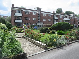 | Appleby Lodge Appleby Lodge is a set of three-storey 1930s blocks of flats with eight entrance doors . The blocks are in a U-shape around a central garden in Rusholme, Manchester . |
 | Owens Park Owens Park is a large hall of residence located in the Fallowfield district of the city of Manchester . The hall is owned by the University of Manchester and houses 1,056 students . The terms ‘Owens Park’ and ‘Fallowfield Campus’ are sometimes used interchangeably . |
 | Fallowfield Campus Fallowfield Campus is the main residential campus of the University of Manchester . It is located 2 miles (3 km) south of the main university site . The campus is connected by Wilmslow Road and the A34 . |
 | Duchess of York Hospital The Duchess of York Hospital was a children’s hospital in Manchester. It was one of the world’s most famous children’s hospitals. Children’s hospital was the first of its kind in the UK. |
 | Stockport Pyramid The Stockport Pyramid, otherwise known as the Co-operative Bank Pyramid or simply The Pyramid is a commercial office building in Stockport, Greater Manchester. |
 | Green Lane (Stockport) Green Lane was the home ground of Stockport County between 1889 and 1902. It was used during the club’s first two seasons in the Football League. |
 | Brinksway Caves The Brinksway Caves are a group of artificial caves located by the River Mersey in Stockport. The caves were excavated by workers chipping away at naturally eroding sandstone on the Cheadle side of the river. |
 | Cheadle Heath Nomads F.C. Cheadle Heath Nomads Football Club was formed in 2004–05 season from a merger of two local clubs. They are currently members of the North West Counties League Division One South and play at the Proseal Stadium. |
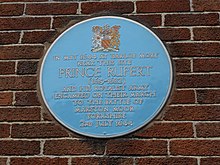
Visit Didsbury plaques
 21
21
plaques
here Didsbury has 21 physical plaques in tourist plaque schemes for you to explore via Walkfo Didsbury plaques audio map when visiting. Plaques like National Heritage’s “Blue Plaques” provide visual geo-markers to highlight points-of-interest at the places where they happened – and Walkfo’s AI has researched additional, deeper content when you visit Didsbury using the app. Experience the history of a location when Walkfo local tourist guide app triggers audio close to each Didsbury plaque. Explore Plaques & History has a complete list of Hartlepool’s plaques & Hartlepool history plaque map.


 Trying to encourage visitors to Didsbury?