Welcome to Visit Derby Places
The Walkfo guide to things to do & explore in Derby
 Visit Derby places using Walkfo for free guided tours of the best Derby places to visit. A unique way to experience Derby’s places, Walkfo allows you to explore Derby as you would a museum or art gallery with audio guides.
Visiting Derby Walkfo Preview
Derby gained city status in 1977 and by the 2011 census its population was 248,700 . The city is home to the world’s second largest aero-engine manufacturer: Rolls-Royce . Home to Lombe’s Mill, an early British factory, Derby has a claim to be one of the birthplaces of the Industrial Revolution . When you visit Derby, Walkfo brings Derby places to life as you travel by foot, bike, bus or car with a mobile phone & headphones.
Derby Places Overview: History, Culture & Facts about Derby
Visit Derby – Walkfo’s stats for the places to visit
With 123 audio plaques & Derby places for you to explore in the Derby area, Walkfo is the world’s largest heritage & history digital plaque provider. The AI continually learns & refines facts about the best Derby places to visit from travel & tourism authorities (like Wikipedia), converting history into an interactive audio experience.
Derby history
Origins
The Roman camp of ‘Derventio’ is considered to have been at Little Chester/Chester Green (grid reference SK353375), the site of the old Roman fort . Later the town was one of the ‘Five Boroughs’ (fortified towns) of the Danelaw . The Viking name Djúra-bý, recorded in Old English as Deoraby, means “village of the deer”
16th–18th centuries
Derby was garrisoned by Parliamentary troops during the Civil War of 1642–1646 . The first civic system of piped water in England was established in Derby in 1692 . Bonnie Prince Charlie set up camp at Derby on 4 December 1745, whilst on his way south to seize the British crown .
Industrial Revolution
In 1717, Derby was the site of the first water-powered silk mill in Britain, built by John Lombe and George Sorocold . In 1759, Jedediah Strutt patented and built a machine called the Derby Rib Attachment that revolutionised the manufacture of hose . The first mill opened in Nottingham in 1770 and was driven by horses .
20th century to present day
Derby was awarded city status on 7 June 1977 by Queen Elizabeth II to mark the 25th anniversary of her ascension to the throne . An industrial boom began in Derby when Rolls-Royce opened a car and aircraft factory in the town in 1907 . In World War I, Derby was targeted by German Zeppelin air bombers who killed five people in a 1916 raid on the town .
Derby landmarks
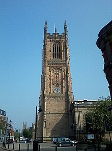
Derby Cathedral tower is 212 feet (65 metres) tall to the tip of the pinnacles. The Silk Mill stands at the southern end of the 24 km (15 mi) stretch of the River Derwent designated a World Heritage Site in 2001. Pickford’s House Museum was built by architect Joseph Pickford in 1770.
Derby geography / climate
Derby is in a relatively low-lying area along the lower valley of the River Derwent. The city is bordered by four national character areas, the Trent Valley Washlands, the Derbyshire Peak Fringe and the Coalfields.
Derby urban area
The Derby Built-up Area (BUA) or Derby Urban Area is an area including Derby and adjoining built-up districts of Derbyshire, including Borrowash and Duffield . It had a total population of 270,468 at the time of the 2011 census . An increase of over 10% since the 2001 census recorded population of 236,738 .
Climate
Derby’s climate is classified as warm and temperate . The average annual temperature is 9.7 °C in Derby . The rainfall in Derby is significant, with precipitation even during the driest month .
Why visit Derby with Walkfo Travel Guide App?
 You can visit Derby places with Walkfo Derby to hear history at Derby’s places whilst walking around using the free digital tour app. Walkfo Derby has 123 places to visit in our interactive Derby map, with amazing history, culture & travel facts you can explore the same way you would at a museum or art gallery with information audio headset. With Walkfo, you can travel by foot, bike or bus throughout Derby, being in the moment, without digital distraction or limits to a specific walking route. Our historic audio walks, National Trust interactive audio experiences, digital tour guides for English Heritage locations are available at Derby places, with a AI tour guide to help you get the best from a visit to Derby & the surrounding areas.
“Curated content for millions of locations across the UK, with 123 audio facts unique to Derby places in an interactive Derby map you can explore.”
Walkfo: Visit Derby Places Map
123 tourist, history, culture & geography spots
Derby historic spots | Derby tourist destinations | Derby plaques | Derby geographic features |
| Walkfo Derby tourism map key: places to see & visit like National Trust sites, Blue Plaques, English Heritage locations & top tourist destinations in Derby | |||
Best Derby places to visit
Derby has places to explore by foot, bike or bus. Below are a selection of the varied Derby’s destinations you can visit with additional content available at the Walkfo Derby’s information audio spots:

New Zealand, Derby
The New Zealand suburb/area of Derby is situated about 1 mile from Derby City Centre . The Suburb is surrounded by the Mackworth Estate, Rowditch, Friargate Coventry and The West End .

The Old Bell Hotel, Derby
The Old Bell Hotel in Derby, Derbyshire, is one of Derby’s oldest and largest coaching inns . Built in 1650, it is a Grade II listed building in the Derby City Statutory List, Buildings of Special Architecture or Historic Interest .

St Werburgh’s Church, Spondon
St. Werburgh’s Church, Spondon, is a parish church in the Church of England. It is located in Derbyshire.

Alvaston
Alvaston is situated on the A6, three miles south-east of Derby city centre. It is bordered to the north by the wards of Derwent, Chaddesden and Spondon. The village of Alvaston has existed since at least the eleventh century.

St Mark’s Church, Derby
St Mark’s Church, Derby is a parish church in the Church of England in Chaddesden, Derbyshire. It was built in the 1930s and is located in the area of Derby.

St Osmund’s Church, Derby
St Osmund’s Church is a Grade II listed Church of England parish church in Derby, Derbyshire. It was built in the 1930s and is one of the largest churches in the country.

St Mary’s Church, Chaddesden
St Mary’s Church is a Church of England parish church in Chaddesden, a suburb of Derby, England. Grade I listed building dating back to the mid-14th century is one of Derby’s oldest churches.

Normanton Barracks
Normanton Barracks was a military installation in Normanton, Derby, England. It was located on the outskirts of Derby and was located in the town of Normanton.

The Sanctuary (Derby)
The Sanctuary is a bird and wildlife sanctuary and designated local nature reserve (LNR) located on Pride Park in the city of Derby, England. Controversial plans by the local council owners to build a closed circuit cycle race track were withdrawn in 2014 following widespread opposition and in the face of legal action.
Visit Derby plaques
 13
13
plaques
here Derby has 13 physical plaques in tourist plaque schemes for you to explore via Walkfo Derby plaques audio map when visiting. Plaques like National Heritage’s “Blue Plaques” provide visual geo-markers to highlight points-of-interest at the places where they happened – and Walkfo’s AI has researched additional, deeper content when you visit Derby using the app. Experience the history of a location when Walkfo local tourist guide app triggers audio close to each Derby plaque. Explore Plaques & History has a complete list of Hartlepool’s plaques & Hartlepool history plaque map.


 Trying to encourage visitors to Derby?