Welcome to Visit Dawley Places
The Walkfo guide to things to do & explore in Dawley
 Visit Dawley places using Walkfo for free guided tours of the best Dawley places to visit. A unique way to experience Dawley’s places, Walkfo allows you to explore Dawley as you would a museum or art gallery with audio guides.
Visiting Dawley Walkfo Preview
Dawley is one of the older settlements in Shropshire, being mentioned in the Domesday Book (1086) It is divided into Dawley Magna and Little Dawley (also shown as Dawley Parva (“Little Dawley”) on older maps) It was originally, in 1963, going to be named ‘Dawley New Town’ before it was decided in 1968 to name ‘Telford’ after the engineer and road-builder Thomas Telford. When you visit Dawley, Walkfo brings Dawley places to life as you travel by foot, bike, bus or car with a mobile phone & headphones.
Dawley Places Overview: History, Culture & Facts about Dawley
Visit Dawley – Walkfo’s stats for the places to visit
With 38 audio plaques & Dawley places for you to explore in the Dawley area, Walkfo is the world’s largest heritage & history digital plaque provider. The AI continually learns & refines facts about the best Dawley places to visit from travel & tourism authorities (like Wikipedia), converting history into an interactive audio experience.
Dawley history
Dawley is mentioned in the Domesday Book and is therefore one of the older settlements in Shropshire. There was a castle in Dawley, but it was demolished around 1648. The site is unknown, although the Castle Pools and Castle Ironworks may indicate the general area where it may have stood.
Dawley geography / climate
Dawley town centre consists of a single pedestrianised street that was previously the main route from Bridgnorth in the south to Wellington in the north. The area around Dawley is rural and provides extensive opportunities for walking.
Why visit Dawley with Walkfo Travel Guide App?
 You can visit Dawley places with Walkfo Dawley to hear history at Dawley’s places whilst walking around using the free digital tour app. Walkfo Dawley has 38 places to visit in our interactive Dawley map, with amazing history, culture & travel facts you can explore the same way you would at a museum or art gallery with information audio headset. With Walkfo, you can travel by foot, bike or bus throughout Dawley, being in the moment, without digital distraction or limits to a specific walking route. Our historic audio walks, National Trust interactive audio experiences, digital tour guides for English Heritage locations are available at Dawley places, with a AI tour guide to help you get the best from a visit to Dawley & the surrounding areas.
“Curated content for millions of locations across the UK, with 38 audio facts unique to Dawley places in an interactive Dawley map you can explore.”
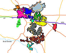
Walkfo: Visit Dawley Places Map
38 tourist, history, culture & geography spots
Dawley historic spots | Dawley tourist destinations | Dawley plaques | Dawley geographic features |
| Walkfo Dawley tourism map key: places to see & visit like National Trust sites, Blue Plaques, English Heritage locations & top tourist destinations in Dawley | |||
Best Dawley places to visit
Dawley has places to explore by foot, bike or bus. Below are a selection of the varied Dawley’s destinations you can visit with additional content available at the Walkfo Dawley’s information audio spots:
 | Telford Telford is a large town in the borough of Telford and Wrekin and ceremonial county of Shropshire . The town was put together in the 1960s and 1970s as a new town on previously industrial and agricultural land and towns . The M54 motorway was completed in 1983, improving the town’s road links with the West Midlands conurbation . Telford Shopping Centre was constructed at the new town’s geographical centre . |
 | Telford Ice Rink Telford Ice Rink is located in the £250m Southwater Complex in Telford, Shropshire . The ice rink is home to English Premier Ice Hockey League team the Telford Tigers . It was in the Brum Episode Ice Skating in 1994 . |
| Wellington Amateurs F.C. Wellington Amateurs Football Club is from Wellington, Shropshire but currently located in Telford . The club plays in the West Midlands (Regional) League Division One . The Ams won Division One three times in four seasons . |
 | Horsehay Horsehay lies in the Dawley Hamlets parish, and on the northern edge of the Ironbridge Gorge area. The name is Anglo-Saxon for ‘an enclosure for horses’ It also has a Methodist Chapel, a village hall, a post office and a golf course. |
 | Malinslee Malinslee is an estate in the Town of Telford and Wrekin. It is very near to the Town Park and the Telford Shopping Centre, Dawley neighbours it. |
 | St James’ Church, Stirchley St James’ Church is a redundant Anglican church in Stirchley, Shropshire, England. It was formerly a separate village but is now part of the new town of Telford. The churchyard is designated as a Scheduled ancient monument. |
 | Coalbrookdale Institute Coalbrookdale Institute is a former library and scientific institute. Dating from the mid-19th century it is now used as a youth hostel. It is a Grade II* listed building. |
 | St Michael’s Church, Madeley St Michael’s Church, Madeley is one of three places of worship that constitute the Parish of Madeley, a Church of England parish. The parish is part of the Diocese of Hereford. |
 | Blists Hill Victorian Town Blists Hill Victorian Town is an open-air museum built on a former industrial complex in Telford, Shropshire. The museum attempts to recreate the sights, sounds and smells of a Victorian town in the late 19th and early 20th centuries. Originally the museum was an industrial region consisting of a brick and tile works, blast furnaces and coal, iron and fire clay mines. |
Visit Dawley plaques
 19
19
plaques
here Dawley has 19 physical plaques in tourist plaque schemes for you to explore via Walkfo Dawley plaques audio map when visiting. Plaques like National Heritage’s “Blue Plaques” provide visual geo-markers to highlight points-of-interest at the places where they happened – and Walkfo’s AI has researched additional, deeper content when you visit Dawley using the app. Experience the history of a location when Walkfo local tourist guide app triggers audio close to each Dawley plaque. Explore Plaques & History has a complete list of Hartlepool’s plaques & Hartlepool history plaque map.


 Trying to encourage visitors to Dawley?