Welcome to Visit Cumbernauld Places
The Walkfo guide to things to do & explore in Cumbernauld
 Visit Cumbernauld places using Walkfo for free guided tours of the best Cumbernauld places to visit. A unique way to experience Cumbernauld’s places, Walkfo allows you to explore Cumbernauld as you would a museum or art gallery with audio guides.
Visiting Cumbernauld Walkfo Preview
Cumbernauld is the ninth most-populous locality in Scotland and the most populated town in north Lanarkshire. It is situated in the centre of Scotland’s Central Belt, positioned between east and west. The town began to spread as the weaving industry of the village was supplemented by mining and quarrying as travel across Scotland became easier due to the Forth and Clyde Canal and the railways being constructed. At the UK census in 2011, the population was approximately 52,000. When you visit Cumbernauld, Walkfo brings Cumbernauld places to life as you travel by foot, bike, bus or car with a mobile phone & headphones.
Cumbernauld Places Overview: History, Culture & Facts about Cumbernauld
Visit Cumbernauld – Walkfo’s stats for the places to visit
With 35 audio plaques & Cumbernauld places for you to explore in the Cumbernauld area, Walkfo is the world’s largest heritage & history digital plaque provider. The AI continually learns & refines facts about the best Cumbernauld places to visit from travel & tourism authorities (like Wikipedia), converting history into an interactive audio experience.
Cumbernauld history
Early history

Cumbernauld’s history stretches at least to Roman times, as Westerwood was a Roman fort on the Antonine Wall, the furthest and most northerly boundary of the Roman Empire. Two Roman temporary camps have been discovered and digitally reconstructed east of the fort, at Tollpark (now covered by Wardpark North) and at Garnhall, similar to the two at Dullatur. One of the most discussed Roman finds from Cumbernauld is a sandstone slab depicting Triton and a naked, kneeling captive. It was found on a farm at Arniebog (between the runway of Cumbernauld Airport and Westerwood Golf Course). The slab can now be viewed at the Hunterian Museum in Glasgow along with an uninscribed altar from Arniebog and other artefacts like the inscribed altar, and statuette found at Castlecary and an older copy of the Bridgeness Slab. In addition to these, an altarstone to Silvanus and the Sky dedicated by a centurion named Verecundus and his wife has been found. Cumbernauld also has the only Roman altar still in the open air in Scotland: the Carrick Stone. The stone has also been linked with Robert Bruce, being the place where he reportedly set up his standard on his way to Bannockburn. There is some evidence that coffins were laid on top of the stone on their way to the cemetery in Kirkintilloch and that the stone has been somewhat worn away. Cumbernauld’s name probably comes from the Gaelic comar nan allt, meaning “meeting of the burns or streams”. There are differing views as to the etymology of this. One theory is that from its high point in the Central Belt, its streams flow both west to the River Clyde and east to the Firth of Forth so Cumbernauld’s name is about it being on a watershed. Another theory ascribes the name to the meeting point of the Red Burn and Bog Stank streams within Cumbernauld Glen. ‘Cumbernauld’ is generally considered to be a Gaelic name. However, early forms containing Cumyr- hint at a Cumbric predecessor derived from *cömber, ‘confluence’ (c.f Welsh cymer, ‘confluence’), synonymous with Aber. This seems to be suffixed with Cumbric *-ïn-alt, a topographical suffix perhaps referring to a hill or slope (Welsh yn allt, ‘at a hill’). There is a record of the charter of the lands of Lenzie and Cumbernauld, granted to William Comyn by Alexander II in 1216. Cumbernauld Castle was first built as a Norman-style motte and bailey castle. Owned by the Comyns, it was situated at the east end of the park, where the motte (mound) is still visible. The Flemings took possession of Cumbernauld Castle and its estate (c.1306) after Robert the Bruce murdered the Red Comyn. Robert Fleming was a staunch supporter of Bruce, and one of his companions that day. To provide proof that Comyn was dead, Fleming cut off his head in order to “let the deed shaw”, a Fleming family motto ever since. On 1 October 1310 Robert the Bruce wrote to Edward II of England from Kildrum trying, unsuccessfully, to establish peace between Scotland and England. Abercromby describes Malcolm Fleming as returning home to Inverbervie with the formerly exiled 21-year-old King David II. Around 1371, the family built a second castle where the Cumbernauld House now stands. One castle wall exists but most of the stonework was recycled for the House or other buildings. King Robert III knighted Malcolm and granted Sir Malcolm Fleming and his heirs the charter to Cumbernauld Castle on 2 April 1406, just two days before the king’s death. Malcolm (and his heir in 1427) were used as hostages to ransom James I back from the English. He also seems to have been arrested by James and imprisoned briefly in Dalkeith Castle. In 1440, this Malcolm Fleming attended the Black Dinner along with his 16-year-old friend Earl William Douglas and his 11-year-old brother David Douglas at Edinburgh Castle. Immediately after the dinner, at which a black bull’s head was served, there was a trial on trumped-up charges and the brothers were beheaded in front of the 10-year-old King James II. Malcolm shared their fate three days later. Malcolm was succeeded by his son Robert. The castle played host to the royalty of Scotland. James IV (1473–1513) wooed Margaret Drummond at Cumbernauld Castle, where Margaret’s sister was married to Lord Fleming. The Drummond sisters lie buried in Dunblane Cathedral following their poisoning, possibly by a government determined to marry an unwilling King James to the sister of Henry VIII of England, Margaret Tudor. The murders made James IV a frequent visitor to Cumbernauld, Margaret Tudor accompanying him on one occasion. It is recorded that during this James’ reign in 1500, the Black Death led to a special plea from the surviving people of Cumbernauld to the church authorities in Glasgow to allow them to establish their own cemetery rather than taking all their dead to St. Ninian’s in Kirkintilloch. They were granted permission to do so, and used the ground at the existing Comyns’ chapel which dates from the end of the 12th century.
Post Reformation history
Mary, Queen of Scots visited the castle and reportedly planted a sweet chestnut tree in the grounds in 1561. James V is recorded as staying for a couple of days at the castle around 14 December 1529. In November 1542, Malcolm Fleming, Lord Chamberlain of Scotland to King James V, was taken prisoner by the English at the Battle of Solway Moss, but released at a ransom of 1,000 marks, paid in July 1548.
Post-Industrial Revolution

In 1841 a fifth of the whole population of 4501 people worked on about 600 hand looms. Weaving was an important part of the town’s industry particularly during the Industrial Revolution. The mining and quarrying industries flourished after the completion of the Forth and Clyde Canal in 1790. Cumbernauld was long a staging-post for changing horses between Glasgow and Edinburgh.
New Town history
Cumbernauld was designated as a New Town in 1955, the third to be designated in Scotland. An additional 3,638 acres (1,472 ha) was added to the designated town area on 19 March 1973 to accommodate a revised target population of 70,000. Housing was originally built in a series of satellite neighbourhoods clustered around town centre.
Modern times
Cumbernauld’s Town Centre is widely regarded as one of the ugliest and least-loved examples of post-war design in Scotland. Designed to be a commerce centre, an entertainment and business venue and a luxury accommodation site, it was widely accepted as Britain’s first shopping centre. However the town never developed to its planned size, and the town centre has never had the life envisaged by town planners.
Why visit Cumbernauld with Walkfo Travel Guide App?
 You can visit Cumbernauld places with Walkfo Cumbernauld to hear history at Cumbernauld’s places whilst walking around using the free digital tour app. Walkfo Cumbernauld has 35 places to visit in our interactive Cumbernauld map, with amazing history, culture & travel facts you can explore the same way you would at a museum or art gallery with information audio headset. With Walkfo, you can travel by foot, bike or bus throughout Cumbernauld, being in the moment, without digital distraction or limits to a specific walking route. Our historic audio walks, National Trust interactive audio experiences, digital tour guides for English Heritage locations are available at Cumbernauld places, with a AI tour guide to help you get the best from a visit to Cumbernauld & the surrounding areas.
“Curated content for millions of locations across the UK, with 35 audio facts unique to Cumbernauld places in an interactive Cumbernauld map you can explore.”
Walkfo: Visit Cumbernauld Places Map
35 tourist, history, culture & geography spots
Cumbernauld historic spots | Cumbernauld tourist destinations | Cumbernauld plaques | Cumbernauld geographic features |
| Walkfo Cumbernauld tourism map key: places to see & visit like National Trust sites, Blue Plaques, English Heritage locations & top tourist destinations in Cumbernauld | |||
Best Cumbernauld places to visit
Cumbernauld has places to explore by foot, bike or bus. Below are a selection of the varied Cumbernauld’s destinations you can visit with additional content available at the Walkfo Cumbernauld’s information audio spots:
 | Carrickstone Carrickstone is on the north of the M80 and west of Cumbernauld Town Centre. The area it now occupies used to be covered by a farm. |
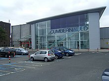
 | Cumbernauld town centre Cumbernauld town centre was designed in the 1950s as a megastructure. Phase 1 was completed between 1963 and 1967, and the centre was opened by Princess Margaret and Lord Snowdon in May 1967. It was expanded in 2007 by the addition of the Antonine Centre, a shopping centre linked to the older structure by walkways and lifts. |
 | Cumbernauld Village Cumbernauld was designated a new town in 1955. The Village has a pre-mediaeval history, with a Roman settlement being built in the area due to its proximity to the Antonine Wall. After the Roman period the settlement remained and grew to such an extent that the Comyns family built their chapel there. |
 | Kildrum Kildrum was the first area to be constructed in Cumbernauld new town, North Lanarkshire, Scotland. It provided housing for workers at Burroughs factory at Old Inns. The main road is in the shape of an arc with residential streets leading from it. |
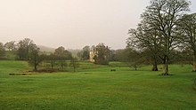
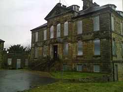 | Cumbernauld House Cumbernauld House is an 18th-century Vivido Scottish country house. It was built in 1731, to designs by William Adam, for John Fleming, 6th Earl of Wigtown. The house is situated on the site of (former) Cumbernault Castle, which was besieged by General Monck in 1651. |
 | Cumbernauld Castle The Motte of the earliest castle survives, and stones of the second castle are incorporated in the present house. Cumbernauld Castle was the predecessor of Cumbernault House in the Park. |
Visit Cumbernauld plaques
 0
0
plaques
here Cumbernauld has 0 physical plaques in tourist plaque schemes for you to explore via Walkfo Cumbernauld plaques audio map when visiting. Plaques like National Heritage’s “Blue Plaques” provide visual geo-markers to highlight points-of-interest at the places where they happened – and Walkfo’s AI has researched additional, deeper content when you visit Cumbernauld using the app. Experience the history of a location when Walkfo local tourist guide app triggers audio close to each Cumbernauld plaque. Currently No Physical Plaques.


 Trying to encourage visitors to Cumbernauld?