Welcome to Visit Crosscanonby Places
The Walkfo guide to things to do & explore in Crosscanonby
 Visit Crosscanonby places using Walkfo for free guided tours of the best Crosscanonby places to visit. A unique way to experience Crosscanonby’s places, Walkfo allows you to explore Crosscanonby as you would a museum or art gallery with audio guides.
Visiting Crosscanonby Walkfo Preview
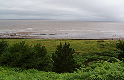
Crosscanonby (otherwise Cross Canonby) is a village and civil parish in Cumbria, England, historically part of Cumberland, near the Lake District National Park. It is situated within the Solway Coast, designated an Area of Outstanding Natural Beauty. The population of the parish was 1,054 in 2001, increasing to 1,113 at the 2011 Census. When you visit Crosscanonby, Walkfo brings Crosscanonby places to life as you travel by foot, bike, bus or car with a mobile phone & headphones.
Crosscanonby Places Overview: History, Culture & Facts about Crosscanonby
Visit Crosscanonby – Walkfo’s stats for the places to visit
With 18 audio plaques & Crosscanonby places for you to explore in the Crosscanonby area, Walkfo is the world’s largest heritage & history digital plaque provider. The AI continually learns & refines facts about the best Crosscanonby places to visit from travel & tourism authorities (like Wikipedia), converting history into an interactive audio experience.
Crosscanonby history

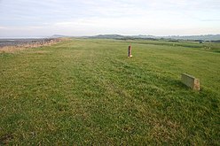
Milefortlet 21 is part of the Hadrian’s Wall World Heritage Site. It is believed to date back to between 79 AD and circa 130 AD, revealing a wealth of information about the lifestyle of Roman troops in Britain. North of the village, along the coast, are the remains of the Elizabethan salt pans. They were begun around 1630 and leased to Richard Barwise in 1634. From 1698 a salt tax was levied.
Crosscanonby etymology
The earliest form of the name was ‘Crosseby’ (1123–50), from the Old Norse “‘krossa býr” meaning ‘bȳ (village, hamlet) marked by crosses’ The name ‘Crosscanonby’ results from the gift of land in Crosby with the church to the church.
Why visit Crosscanonby with Walkfo Travel Guide App?
 You can visit Crosscanonby places with Walkfo Crosscanonby to hear history at Crosscanonby’s places whilst walking around using the free digital tour app. Walkfo Crosscanonby has 18 places to visit in our interactive Crosscanonby map, with amazing history, culture & travel facts you can explore the same way you would at a museum or art gallery with information audio headset. With Walkfo, you can travel by foot, bike or bus throughout Crosscanonby, being in the moment, without digital distraction or limits to a specific walking route. Our historic audio walks, National Trust interactive audio experiences, digital tour guides for English Heritage locations are available at Crosscanonby places, with a AI tour guide to help you get the best from a visit to Crosscanonby & the surrounding areas.
“Curated content for millions of locations across the UK, with 18 audio facts unique to Crosscanonby places in an interactive Crosscanonby map you can explore.”
Walkfo: Visit Crosscanonby Places Map
18 tourist, history, culture & geography spots
Crosscanonby historic spots | Crosscanonby tourist destinations | Crosscanonby plaques | Crosscanonby geographic features |
| Walkfo Crosscanonby tourism map key: places to see & visit like National Trust sites, Blue Plaques, English Heritage locations & top tourist destinations in Crosscanonby | |||
Best Crosscanonby places to visit
Crosscanonby has places to explore by foot, bike or bus. Below are a selection of the varied Crosscanonby’s destinations you can visit with additional content available at the Walkfo Crosscanonby’s information audio spots:
 | Alauna (Maryport) Alauna was a castrum or fort in the Roman province of Britannia. It occupied a coastal site just north of the town of Maryport in the English county of Cumbria (formerly part of Cumberland) |
 | Milefortlet 23 Milefortlets and intervening stone watchtowers extended from the western end of Hadrian’s Wall, along the Cumbrian coast. Milefortlet 23 (Sea Brows) has been located and surveyed. |
 | Milefortlet 22 Milefortlets and intervening stone watchtowers extended from the western end of Hadrian’s Wall, along the Cumbrian coast. Milefortlet 22 (Brownrigg) has been located and excavated. |
 | St Mungo’s Church, Dearham The church is dedicated to St Mungo, also known as Kentigern, the apostle of Strathclyde. It is an active Anglican parish church in the deanery of Solway, the archdeaconry of West Cumberland and the diocese of Carlisle. |
 | Oughterside and Allerby Oughterside and Allerby is a civil parish in Allerdale district, Cumbria, England. In the 2011 census it had a population of 619. The parish is bordered by Hayton and Mealo to the north, Aspatria, Plumbland and Gilcrux to the south. |
 | St John the Evangelist’s Church, Crosscanonby St John the Evangelist’s Church is in the village of Crosscanonby, Cumbria. It is an active Anglican parish church in the deanery of Solway, the archdeaconry of West Cumberland and the diocese of Carlisle. The church is recorded in the National Heritage List for England as a designated Grade I listed building. |
 | Milefortlet 20 Milefortlets and intervening stone watchtowers extended from the western end of Hadrian’s Wall, along the Cumbrian coast and were linked by a wooden palisade. Milefortlet 20 (Low Mire) has been located and excavated. |
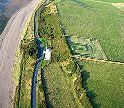 | Milefortlet 21 Milefortlet 21 (Swarthy Hill) is a milefortlet of the Roman Cumbrian Coast defences. These defences were contemporary with defensive structures on Hadrian’s Wall. Its remains exist as reconstructed turf ramparts (to a height of about 1 metre (3.3 ft) and ditch. |
 | Allerby Allerby is a hamlet in the civil parish of Oughterside, Allerdale district, Cumbria, England. |
Visit Crosscanonby plaques
 0
0
plaques
here Crosscanonby has 0 physical plaques in tourist plaque schemes for you to explore via Walkfo Crosscanonby plaques audio map when visiting. Plaques like National Heritage’s “Blue Plaques” provide visual geo-markers to highlight points-of-interest at the places where they happened – and Walkfo’s AI has researched additional, deeper content when you visit Crosscanonby using the app. Experience the history of a location when Walkfo local tourist guide app triggers audio close to each Crosscanonby plaque. Currently No Physical Plaques.


 Trying to encourage visitors to Crosscanonby?