Welcome to Visit Coleford, Somerset Places
The Walkfo guide to things to do & explore in Coleford, Somerset
 Visit Coleford, Somerset places using Walkfo for free guided tours of the best Coleford, Somerset places to visit. A unique way to experience Coleford, Somerset’s places, Walkfo allows you to explore Coleford, Somerset as you would a museum or art gallery with audio guides.
Visiting Coleford, Somerset Walkfo Preview
Coleford is situated on the Mells River in the Mendip Hills five miles west of Frome. The parish has a population of 2,313 in 2011. When you visit Coleford, Somerset, Walkfo brings Coleford, Somerset places to life as you travel by foot, bike, bus or car with a mobile phone & headphones.
Coleford, Somerset Places Overview: History, Culture & Facts about Coleford, Somerset
Visit Coleford, Somerset – Walkfo’s stats for the places to visit
With 27 audio plaques & Coleford, Somerset places for you to explore in the Coleford, Somerset area, Walkfo is the world’s largest heritage & history digital plaque provider. The AI continually learns & refines facts about the best Coleford, Somerset places to visit from travel & tourism authorities (like Wikipedia), converting history into an interactive audio experience.
Coleford, Somerset history
Coleford was listed in the Domesday Book of 1086 as Colford, meaning the hill ford, or the coal ford. The village once had several coal mines as part of the Somerset coalfield. The Natural Stone Products factory is built on the site of Newbury Colliery.
Why visit Coleford, Somerset with Walkfo Travel Guide App?
 You can visit Coleford, Somerset places with Walkfo Coleford, Somerset to hear history at Coleford, Somerset’s places whilst walking around using the free digital tour app. Walkfo Coleford, Somerset has 27 places to visit in our interactive Coleford, Somerset map, with amazing history, culture & travel facts you can explore the same way you would at a museum or art gallery with information audio headset. With Walkfo, you can travel by foot, bike or bus throughout Coleford, Somerset, being in the moment, without digital distraction or limits to a specific walking route. Our historic audio walks, National Trust interactive audio experiences, digital tour guides for English Heritage locations are available at Coleford, Somerset places, with a AI tour guide to help you get the best from a visit to Coleford, Somerset & the surrounding areas.
“Curated content for millions of locations across the UK, with 27 audio facts unique to Coleford, Somerset places in an interactive Coleford, Somerset map you can explore.”
Walkfo: Visit Coleford, Somerset Places Map
27 tourist, history, culture & geography spots
Coleford, Somerset historic spots | Coleford, Somerset tourist destinations | Coleford, Somerset plaques | Coleford, Somerset geographic features |
| Walkfo Coleford, Somerset tourism map key: places to see & visit like National Trust sites, Blue Plaques, English Heritage locations & top tourist destinations in Coleford, Somerset | |||
Best Coleford, Somerset places to visit
Coleford, Somerset has places to explore by foot, bike or bus. Below are a selection of the varied Coleford, Somerset’s destinations you can visit with additional content available at the Walkfo Coleford, Somerset’s information audio spots:
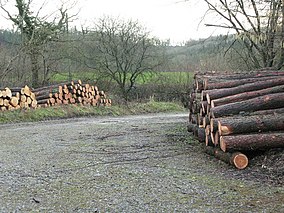 | Harridge Wood From about 1300 AD part of the wood was the scene of coal mining, which continued until around 1800. Large areas were planted for timber in the mid-20th century, and this continues to be harvested. The nature reserve is steadily reintroducing the original flora. |
 | Stoke Lane Slocker Stoke Lane Slocker is 2.18 km in length and reaches a depth of 30m. It was previously known as Stoke Lane Swallet, but now the local name is preferred. The origin of the word “Slocker” is obscure. |
 | Dinies Camp Dinies Camp is a univallate Iron Age hill fort enclosure in Mendip district of Somerset. The hill fort is situated approximately 1 mile (1.6 km) south-west from the village of Downhead. |
 | St. Dunstan’s Well Catchment St Dunstan’s Well Catchment (grid reference ST668475) is a Site of Special Scientific Interest. Formerly known as Stoke St Michael Slocker, it contains nine SSSI units. The site was notified in 1967. |
 | Church of St Michael, Stoke St Michael The Anglican Church of St Michael in Stoke St Michael, Somerset, was built around 1400. It is a Grade II* listed building. |
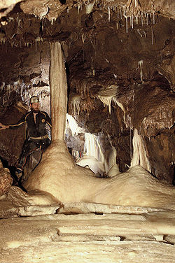 | Shatter Cave Shatter Cave is a cave in Fairy Cave Quarry, near Stoke St Michael in the limestone of the Mendip Hills, in Somerset. It falls within the St. Dunstan’s Well Catchment Site of Special Scientific Interest. |
 | Mells Park Mells Park is a country estate of 140 hectares (350 acres) near Mells, Somerset. It originated as a 17th-century deer park, probably created by the Horner family. It contains Park House, a Grade II* listed building, built in 1925 in neoclassical style by the architect Edwin Lutyens. |
Visit Coleford, Somerset plaques
 0
0
plaques
here Coleford, Somerset has 0 physical plaques in tourist plaque schemes for you to explore via Walkfo Coleford, Somerset plaques audio map when visiting. Plaques like National Heritage’s “Blue Plaques” provide visual geo-markers to highlight points-of-interest at the places where they happened – and Walkfo’s AI has researched additional, deeper content when you visit Coleford, Somerset using the app. Experience the history of a location when Walkfo local tourist guide app triggers audio close to each Coleford, Somerset plaque. Currently No Physical Plaques.


 Trying to encourage visitors to Coleford, Somerset?