Welcome to Visit Coleby, North Kesteven Places
The Walkfo guide to things to do & explore in Coleby, North Kesteven
 Visit Coleby, North Kesteven places using Walkfo for free guided tours of the best Coleby, North Kesteven places to visit. A unique way to experience Coleby, North Kesteven’s places, Walkfo allows you to explore Coleby, North Kesteven as you would a museum or art gallery with audio guides.
Visiting Coleby, North Kesteven Walkfo Preview
Coleby is a village and civil parish in the North Kesteven district of Lincolnshire. It is situated on the A607, and approximately 6 miles south from the city and county town of Lincoln. When you visit Coleby, North Kesteven, Walkfo brings Coleby, North Kesteven places to life as you travel by foot, bike, bus or car with a mobile phone & headphones.
Coleby, North Kesteven Places Overview: History, Culture & Facts about Coleby, North Kesteven
Visit Coleby, North Kesteven – Walkfo’s stats for the places to visit
 With 11 audio plaques & Coleby, North Kesteven places for you to explore in the Coleby, North Kesteven area, Walkfo is the world’s largest heritage & history digital plaque provider. The AI continually learns & refines facts about the best Coleby, North Kesteven places to visit from travel & tourism authorities (like Wikipedia), converting history into an interactive audio experience.
Coleby, North Kesteven landmarks
Church of All Saints
Coleby Grade I listed Anglican parish church is dedicated to All Saints. The original church was built by the Anglo-Saxons, extended by the Normans and had a new spire built on top of the Saxon tower.
Coleby Hall
Coleby Hall is a Grade II* listed country house which stands near the church in a park of around 50 acres (0.2 km) It is a gabled house constructed in coursed rubble and ashlar with a red-tiled ridge roof, built in 1628 for Sir William Lister of Rippingale, the father of Thomas Lister.
RAF Coleby Grange

RAF Coleby Grange opened in 1939 with grass runways as a relief landing ground for RAF Cranwell. In May 1941 it was transferred to 12 Group, RAF Fighter Command and became a satellite station for RAF Digby. The station re-opened in 1959 as a Thor IRBM launching base, it closed again in 1963.
Why visit Coleby, North Kesteven with Walkfo Travel Guide App?
 You can visit Coleby, North Kesteven places with Walkfo Coleby, North Kesteven to hear history at Coleby, North Kesteven’s places whilst walking around using the free digital tour app. Walkfo Coleby, North Kesteven has 11 places to visit in our interactive Coleby, North Kesteven map, with amazing history, culture & travel facts you can explore the same way you would at a museum or art gallery with information audio headset. With Walkfo, you can travel by foot, bike or bus throughout Coleby, North Kesteven, being in the moment, without digital distraction or limits to a specific walking route. Our historic audio walks, National Trust interactive audio experiences, digital tour guides for English Heritage locations are available at Coleby, North Kesteven places, with a AI tour guide to help you get the best from a visit to Coleby, North Kesteven & the surrounding areas.
“Curated content for millions of locations across the UK, with 11 audio facts unique to Coleby, North Kesteven places in an interactive Coleby, North Kesteven map you can explore.”
Walkfo: Visit Coleby, North Kesteven Places Map
11 tourist, history, culture & geography spots
Coleby, North Kesteven historic spots | Coleby, North Kesteven tourist destinations | Coleby, North Kesteven plaques | Coleby, North Kesteven geographic features |
| Walkfo Coleby, North Kesteven tourism map key: places to see & visit like National Trust sites, Blue Plaques, English Heritage locations & top tourist destinations in Coleby, North Kesteven | |||
Best Coleby, North Kesteven places to visit
Coleby, North Kesteven has places to explore by foot, bike or bus. Below are a selection of the varied Coleby, North Kesteven’s destinations you can visit with additional content available at the Walkfo Coleby, North Kesteven’s information audio spots:
| Coleby, North Kesteven Coleby is a village and civil parish in the North Kesteven district of Lincolnshire. It is situated on the A607, and approximately 6 miles south from the city and county town of Lincoln. |
| Ermine Street Old English name was “Earninga Straete” (1012), named after a tribe called the Earningas. The original Celtic and Roman names for the route remain unknown. It is also known as the Old North Road from London to where it joins the A1 Great North Road. |
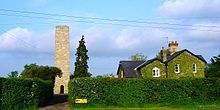 | Dunston Pillar Dunston Pillar is a Grade II listed stone tower in Lincolnshire. It stands beside the A15 road approximately 6 miles (10 km) south of Lincoln. |
Visit Coleby, North Kesteven plaques
 0
0
plaques
here Coleby, North Kesteven has 0 physical plaques in tourist plaque schemes for you to explore via Walkfo Coleby, North Kesteven plaques audio map when visiting. Plaques like National Heritage’s “Blue Plaques” provide visual geo-markers to highlight points-of-interest at the places where they happened – and Walkfo’s AI has researched additional, deeper content when you visit Coleby, North Kesteven using the app. Experience the history of a location when Walkfo local tourist guide app triggers audio close to each Coleby, North Kesteven plaque. Currently No Physical Plaques.


 Trying to encourage visitors to Coleby, North Kesteven?