Welcome to Visit Coldean Places The Walkfo guide to things to do & explore in Coldean
Visit Coldean places using Walkfo for free guided tours of the best Coldean places to visit. A unique way to experience Coldean’s places, Walkfo allows you to explore Coldean as you would a museum or art gallery with audio guides.
Visiting Coldean Walkfo Preview Coldean is located in the northeast corner of the urban area of Brighton and Hove. It was developed by Brighton Corporation in the 1950s as one of several postwar council estates. The estate occupies a deep valley on the historic boundary of Falmer and Stanmer parishes. It is characterised by low-density housing, with roads following contours of the landscape. When you visit Coldean, Walkfo brings Coldean places to life as you travel by foot, bike, bus or car with a mobile phone & headphones.
Coldean Places Overview: History, Culture & Facts about Coldean
Visit Coldean – Walkfo’s stats for the places to visit
With 71 audio plaques & Coldean places for you to explore in the Coldean area, Walkfo is the world’s largest heritage & history digital plaque provider. The AI continually learns & refines facts about the best Coldean places to visit from travel & tourism authorities (like Wikipedia), converting history into an interactive audio experience.
Coldean history
Coldean was originally a deep, steep-sided, undeveloped valley split between the parishes of Falmer and Stanmer, with Hollingbury to the west, Wild Park and the 584-foot (178 m) Hollingburge Hill to the southwest. Residential development began in 1934, when the Parkside estate was laid out by private developers in the southwest corner of the valley. The area was beyond the Brighton Corporation borough boundary in Falmer parish. In 1950, the Corporation bought the rest of the land; the whole valley was brought within the Borough of Brighton.
Why visit Coldean with Walkfo Travel Guide App?
You can visit Coldean places with Walkfo Coldean to hear history at Coldean’s places whilst walking around using the free digital tour app. Walkfo Coldean has 71 places to visit in our interactive Coldean map, with amazing history, culture & travel facts you can explore the same way you would at a museum or art gallery with information audio headset. With Walkfo, you can travel by foot, bike or bus throughout Coldean, being in the moment, without digital distraction or limits to a specific walking route. Our historic audio walks, National Trust interactive audio experiences, digital tour guides for English Heritage locations are available at Coldean places, with a AI tour guide to help you get the best from a visit to Coldean & the surrounding areas.
“Curated content for millions of locations across the UK, with 71 audio facts unique to Coldean places in an interactive Coldean map you can explore.”
Walkfo Coldean tourism map key: places to see & visit like National Trust sites, Blue Plaques, English Heritage locations & top tourist destinations in Coldean
Best Coldean places to visit
Coldean has places to explore by foot, bike or bus. Below are a selection of the varied Coldean’s destinations you can visit with additional content available at the Walkfo Coldean’s information audio spots:
St Luke’s Church, Queen’s Park, Brighton St Luke’s Church is an Anglican church in the Queen’s Park area of Brighton. It was designed in the 1880s by Sir Arthur Blomfield in the Early English style. It has been given listed building status because of its architectural importance.
Church of the Annunciation, Brighton The Church of the Annunciation was built in the 1860s on behalf of Rev. Arthur Wagner. It served a new area of poor housing in what is now the Hanover district. The church is a Grade II listed building.
St Wilfrid’s Church, Brighton St Wilfrid’s Church is a former Anglican church in the Elm Grove area of Brighton, part of the English city of Brighton and Hove. It was declared redundant after less than 50 years as a place of worship, and was converted into sheltered housing with minimal alteration to the exterior.
St Joseph’s Church, Brighton St Joseph’s Church is a Roman Catholic church in the Elm Grove area of Brighton, part of the English city of Brighton and Hove. It is one of eleven Roman Catholic churches in the city. The church was built in several stages, and outstanding debts meant that its official dedication took place in 1979.
Percy and Wagner Almshouses The Percy and Wagner Almshouses are a group of 12 almshouses in the inner-city Hanover area of the English coastal city of Brighton and Hove. The first six date from 1795 and are among the few pre-19th-century buildings left in the city. The additional houses of 1859 were provided for unmarried women. The houses were saved from demolition in the 1970s and were rebuilt instead and are still occupied.
Whitehawk Camp Whitehawk Camp is the remains of a causewayed enclosure on Whitehawk Hill near Brighton, East Sussex. Causewayed enclosures are a form of early Neolithic earthwork that were built in England from shortly before 3700 BC until about 3300 BC. Site consists of four roughly concentric circular circular circular ditches, with banks of earth along the interior of the ditches evident in some places.
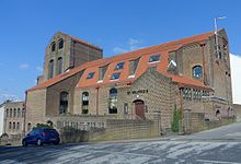
St Martin’s Church, Brighton St Martin’s Church is the largest Anglican church in Brighton, England. It dates back to the mid-Victorian era and is noted for its ornate interior. It is located northeast of the city centre and north of the seafront.
Roundhill Crescent Roundhill Crescent is a late-19th-century housing development in Round Hill, an inner suburb of the English coastal city of Brighton and Hove. Partly developed in the 1860s with large terraced houses on a steeply sloping open hillside. England’s first hospital for the treatment of mental illness was founded in the crescent in 1905. The crescent occupies a prominent place on Brighton’s skyline.
St Augustine’s Church, Brighton St Augustine’s Church is a former Anglican church in Brighton, part of the English city of Brighton and Hove. Built in 1896 and extended in 1914, its parish was extended after a nearby church closed, but in 2003 it was declared redundant itself. The building is listed at Grade II in view of its architectural importance.
Preston Barracks Preston Barracks was a military installation in Lewes Road, Preston, Brighton. The buildings and site are being converted into student residences and a business school.
Visit Coldean plaques
13 plaques hereColdean has 13 physical plaques in tourist plaque schemes for you to explore via Walkfo Coldean plaques audio map when visiting. Plaques like National Heritage’s “Blue Plaques” provide visual geo-markers to highlight points-of-interest at the places where they happened – and Walkfo’s AI has researched additional, deeper content when you visit Coldean using the app. Experience the history of a location when Walkfo local tourist guide app triggers audio close to each Coldean plaque. Explore Plaques & History has a complete list of Hartlepool’s plaques & Hartlepool history plaque map.
Experience Coldean audio walks & tours
Walkfo guides for things to do / places to visit in Coldean allows exploration as you would do an art gallery or museum. Walk close to one of Coldean’s 71 historic places & our digital tour guide will create an audio story for that spot. With headphone connected, you can explore Coldean freely by foot, bike or bus – with your own personal tour guide in your pocket.
Explore Coldean Map App
Our visit Coldean map shows you things-to-do & places you can visit in Coldean & surrounding areas using the Walkfo digital audio tour guide app. Each spot has plaque, building, street or area information on history, culture or tourism.
You can set your Walkfo’s Coldean tourist map to find historic & tourism spots within 1km, 3km & 5km of the Coldean centre, depending on how far you plan to explore whilst you visit Coldean area at LONG:-0.11, LAT:50.861388888889.
Walkfo App
Walkfo
Walkfo is free to download & use (for a limited time period), so if you are looking to explore Coldean, go to your App Store to search for “Walkfo” or follow a links below and install on your mobile phone. Walkfo is designed for use with headphones or AirPods, so you can walk & explore whilst learning about the things around you without digital distraction.
Things to do & visit in Coldean / surrounding areas
● Pepper Pot, Brighton ● St Luke’s Church, Queen’s Park, Brighton ● Church of the Annunciation, Brighton ● St Wilfrid’s Church, Brighton ● Elm Grove, Brighton ● St Joseph’s Church, Brighton ● Percy and Wagner Almshouses ● Whitehawk Camp ● The Level, Brighton ● Brighton General Hospital ● Royal New Ground ● Park Crescent, Brighton ● Whitehawk Hill ● Prince of Wales Ground ● St Martin’s Church, Brighton ● Cowley Club ● Brighton Forum ● Round Hill, Brighton ● Brighton railway works ● New England Quarter ● Roundhill Crescent ● Duke of York’s Picture House, Brighton ● Brighton Electric ● St Augustine’s Church, Brighton ● Brighton Lovers Walk Traction and Rolling Stock Maintenance Depot ● Preston Barracks ● Hollingdean ● Prestonville, Brighton ● Bevendean ● Moulsecoomb Place
● Preston Park, Brighton ● Bevendean Down ● St Peter’s Church, Preston Village, Brighton ● Moulsecoomb ● St Mary’s Church, Preston Park ● Preston Manor, Brighton ● Preston Park Velodrome ● St John the Evangelist’s Church, Preston Village ● Preston Village, Brighton ● Tower House, Brighton ● Withdean Stadium ● Withdean ● Brighton and Lewes Downs Biosphere Reserve ● The Keep, Brighton ● Coldean ● Wild Park ● Hollingbury Castle ● Stanmer Park ● Falmer Stadium ● Stanmer House ● Stanmer ● Stanmer Church ● Hollingbury ● Ladies Mile, Brighton ● Woodingdean Water Well ● Patcham ● Southdown House ● All Saints Church, Patcham ● Patcham Place ● Patcham Tunnel ● Westdene ● Withdean and Westdene Woods ● Waterhall Mill, Patcham ● Chattri, Brighton ● Falmer ● Woodingdean ● Hanover, Brighton ● St Bartholomew’s Church, Brighton ● University of Sussex
Getting to / around Coldean – transport link, station & street map
Getting around in Coldean using public transportation may include road, street, train, underground, bus or tram transport options. Walkfo has identified the following Coldean places with historic / cultural / factual content when you visit:
Local Coldean Public Transport Stations
Coldean Notable Streets & Road Destinations
Whitehawk Hill transmitting station
Hartington Road Halt railway station
Lewes Road railway station
Falmer railway station
London Road (Brighton) railway station
Moulsecoomb railway station
Preston Park railway station
Bear Road, Brighton
London Road viaduct
[transportsummary]
Local Coldean historians & Coldean tour guides
Trying to encourage visitors to Coldean? Walkfo has millions audio places already available but Walkfo Creator gives Coldean’s places, attractions & landmarks ability to create their own unique outdoor audio museums & using our simple & easy to use Walkfo Creator. – Creating a new audio experience for your Coldean place is free* and quick (15+ minutes if you prepare text content) to use, with Walkfo Creator doing the hard work of generating AI audio files for geo-spots from the text you provide with a simply click on a map. – The 100 Amazing Coldean Places is just one example of an outdoor museum created using Walkfo Creator (pictured to the left) for people to safely explore during Covid-19 times whilst visiting a city. Our tool is open to tourism organisations, travel destinations & National Trust locations to create their own audio walks to offer free when people visit Coldean destinations. – Walkfo itself is looking to partner with websites offering things-to-do / what’s on events listings to enhance the content of our ‘visit-Coldean’ web pages (for example: www.visitColdean.com). If you are interested in partnering, please contact us to discuss options.
* Walkfo Creator is free to use for a limited number of audio spots within a map with a license fee applicable when more than 20 audio spots within location walk are created. v1.1336
 Visit Coldean places using Walkfo for free guided tours of the best Coldean places to visit. A unique way to experience Coldean’s places, Walkfo allows you to explore Coldean as you would a museum or art gallery with audio guides.
 You can visit Coldean places with Walkfo Coldean to hear history at Coldean’s places whilst walking around using the free digital tour app. Walkfo Coldean has 71 places to visit in our interactive Coldean map, with amazing history, culture & travel facts you can explore the same way you would at a museum or art gallery with information audio headset. With Walkfo, you can travel by foot, bike or bus throughout Coldean, being in the moment, without digital distraction or limits to a specific walking route. Our historic audio walks, National Trust interactive audio experiences, digital tour guides for English Heritage locations are available at Coldean places, with a AI tour guide to help you get the best from a visit to Coldean & the surrounding areas.


 13
13


 Trying to encourage visitors to Coldean?