Welcome to Visit Coelbren, Powys Places
The Walkfo guide to things to do & explore in Coelbren, Powys
 Visit Coelbren, Powys places using Walkfo for free guided tours of the best Coelbren, Powys places to visit. A unique way to experience Coelbren, Powys’s places, Walkfo allows you to explore Coelbren, Powys as you would a museum or art gallery with audio guides.
Visiting Coelbren, Powys Walkfo Preview
Henrhyd Falls, a 27m high waterfall, is a National Trust-managed visitor attraction on the Nant Llech. The name ‘Coelbren’ is recorded in the name Tyre y Kolbren in 1503 where it signifies the sharing of land (modern Welsh ‘tir’) by means of drawing lots. When you visit Coelbren, Powys, Walkfo brings Coelbren, Powys places to life as you travel by foot, bike, bus or car with a mobile phone & headphones.
Coelbren, Powys Places Overview: History, Culture & Facts about Coelbren, Powys
Visit Coelbren, Powys – Walkfo’s stats for the places to visit
 With 16 audio plaques & Coelbren, Powys places for you to explore in the Coelbren, Powys area, Walkfo is the world’s largest heritage & history digital plaque provider. The AI continually learns & refines facts about the best Coelbren, Powys places to visit from travel & tourism authorities (like Wikipedia), converting history into an interactive audio experience.
Coelbren, Powys history
Roman road of Sarn Helen runs close to the village on its eastern side. The Brecon Forest Tramroad was constructed through the village in the 1820s. From the 1873, Coelbren was the location of a significant junction on the Neath and Brecon Railway. The route to Swansea Vale has now been converted into a cycleway.
Why visit Coelbren, Powys with Walkfo Travel Guide App?
 You can visit Coelbren, Powys places with Walkfo Coelbren, Powys to hear history at Coelbren, Powys’s places whilst walking around using the free digital tour app. Walkfo Coelbren, Powys has 16 places to visit in our interactive Coelbren, Powys map, with amazing history, culture & travel facts you can explore the same way you would at a museum or art gallery with information audio headset. With Walkfo, you can travel by foot, bike or bus throughout Coelbren, Powys, being in the moment, without digital distraction or limits to a specific walking route. Our historic audio walks, National Trust interactive audio experiences, digital tour guides for English Heritage locations are available at Coelbren, Powys places, with a AI tour guide to help you get the best from a visit to Coelbren, Powys & the surrounding areas.
“Curated content for millions of locations across the UK, with 16 audio facts unique to Coelbren, Powys places in an interactive Coelbren, Powys map you can explore.”
Walkfo: Visit Coelbren, Powys Places Map
16 tourist, history, culture & geography spots
Coelbren, Powys historic spots | Coelbren, Powys tourist destinations | Coelbren, Powys plaques | Coelbren, Powys geographic features |
| Walkfo Coelbren, Powys tourism map key: places to see & visit like National Trust sites, Blue Plaques, English Heritage locations & top tourist destinations in Coelbren, Powys | |||
Best Coelbren, Powys places to visit
Coelbren, Powys has places to explore by foot, bike or bus. Below are a selection of the varied Coelbren, Powys’s destinations you can visit with additional content available at the Walkfo Coelbren, Powys’s information audio spots:
| Coelbren, Powys Henrhyd Falls, a 27m high waterfall, is a National Trust-managed visitor attraction on the Nant Llech. The name ‘Coelbren’ is recorded in the name Tyre y Kolbren in 1503 where it signifies the sharing of land (modern Welsh ‘tir’) by means of drawing lots. |
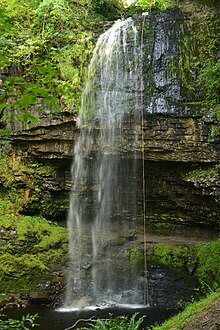 | Henrhyd Falls Henrhyd Falls is the tallest waterfall in southern Wales with a drop of 90 feet (27 m) It lies on National Trust land, in the county of Powys. The nearest settlement to it is Coelbren, on the road between Glynneath and Abercraf. |
 | Cribarth Cribarth, sometimes referred to as the Sleeping Giant, is a hill in the Brecon Beacons National Park in Powys (formerly Brecknockshire) in southern Wales. The summit lies on the broken ridge at an elevation of 428 m (1,404 ft) at OS grid reference SN 831143. |
 | Craig-y-Nos Castle Craig-y-nos Castle is a Victorian-Gothic country house in Powys, Wales. Built on parkland beside the River Tawe in the upper Swansea Valley, it is located on the southeastern edge of the Black Mountain. |
 | Ogof Ffynnon Ddu Ogof Ffynnon Ddu (Welsh for cave of the black spring) is a cave under a hillside in the area surrounding Penwyllt in the Upper Swansea Valley in South Wales. It is the second longest cave in Wales and the deepest in the United Kingdom. |
Visit Coelbren, Powys plaques
 0
0
plaques
here Coelbren, Powys has 0 physical plaques in tourist plaque schemes for you to explore via Walkfo Coelbren, Powys plaques audio map when visiting. Plaques like National Heritage’s “Blue Plaques” provide visual geo-markers to highlight points-of-interest at the places where they happened – and Walkfo’s AI has researched additional, deeper content when you visit Coelbren, Powys using the app. Experience the history of a location when Walkfo local tourist guide app triggers audio close to each Coelbren, Powys plaque. Currently No Physical Plaques.


 Trying to encourage visitors to Coelbren, Powys?