Welcome to Visit Clowne Places
The Walkfo guide to things to do & explore in Clowne
 Visit Clowne places using Walkfo for free guided tours of the best Clowne places to visit. A unique way to experience Clowne’s places, Walkfo allows you to explore Clowne as you would a museum or art gallery with audio guides.
Visiting Clowne Walkfo Preview
Clowne lies 9 miles (14 km) north east of Chesterfield and 7 miles (11 km) south west of Worksop. The population at the 2001 Census was 7,447 increasing to 7,590 at the 2011 Census. In 2019, it was estimated that the population was around 8,393. When you visit Clowne, Walkfo brings Clowne places to life as you travel by foot, bike, bus or car with a mobile phone & headphones.
Clowne Places Overview: History, Culture & Facts about Clowne
Visit Clowne – Walkfo’s stats for the places to visit
With 22 audio plaques & Clowne places for you to explore in the Clowne area, Walkfo is the world’s largest heritage & history digital plaque provider. The AI continually learns & refines facts about the best Clowne places to visit from travel & tourism authorities (like Wikipedia), converting history into an interactive audio experience.
Clowne history
Toponymy
Clowne, originally Cloone, has been spelt in various ways over the last 1,000 years including, Cloune, Clone, Clowen, and most recently Clown. It was mentioned in the Domesday Book of 1086. The names of two railway stations in the town were spelled differently at different times.
Markland Grips
Hollinhill and Markland Grips are on the southern end of the band of magnesian limestone which runs south from Durham to the Derbyshire-Nottinghamshire border. In the cliff sides are several small caves, rock shelters and fissures where human bones have been carbon dated to the early Neolithic period. During the Roman period, a fort guarding an important ridgeway which ran north to south was close to Clowne.
Early history
The first recorded mention of Clowne manor was in 1002 when the owner was Wulfric Spot. The medieval cross and the church of St. John the Baptist are the oldest surviving structures in the village. The plague struck Clowne in 1586 and 1606 and victims were buried away from the village at Monument Field or Plague Field.
Industrial Revolution
During the Industrial Revolution, Clowne grew exponentially, swallowing the neighbouring villages of Hickinwood and Markland and becoming a mining town. The sinking of the 1,000 feet (300 m) deep mine, Southgate Colliery, in 1877 brought in workers from elsewhere. At its peak it employed 400 men and produced 600 tons of coal per day.
Clowne geography / climate
Clowne in the north east corner of Derbyshire between Chesterfield and Worksop. It is situated on the old Mansfield to Rotherham road, now the A618, at its junction with the A616 road from Newark-on-Trent to the M1 motorway at nearby Barlborough. The town is surrounded by rolling farmland, mostly arable.
Why visit Clowne with Walkfo Travel Guide App?
 You can visit Clowne places with Walkfo Clowne to hear history at Clowne’s places whilst walking around using the free digital tour app. Walkfo Clowne has 22 places to visit in our interactive Clowne map, with amazing history, culture & travel facts you can explore the same way you would at a museum or art gallery with information audio headset. With Walkfo, you can travel by foot, bike or bus throughout Clowne, being in the moment, without digital distraction or limits to a specific walking route. Our historic audio walks, National Trust interactive audio experiences, digital tour guides for English Heritage locations are available at Clowne places, with a AI tour guide to help you get the best from a visit to Clowne & the surrounding areas.
“Curated content for millions of locations across the UK, with 22 audio facts unique to Clowne places in an interactive Clowne map you can explore.”
Walkfo: Visit Clowne Places Map
22 tourist, history, culture & geography spots
Clowne historic spots | Clowne tourist destinations | Clowne plaques | Clowne geographic features |
| Walkfo Clowne tourism map key: places to see & visit like National Trust sites, Blue Plaques, English Heritage locations & top tourist destinations in Clowne | |||
Best Clowne places to visit
Clowne has places to explore by foot, bike or bus. Below are a selection of the varied Clowne’s destinations you can visit with additional content available at the Walkfo Clowne’s information audio spots:
 | New Barlborough New Barlborough is an area of Bolsover, Derbyshire, consisting of several housing estates and a single row of houses. It is located along the A619, between Chesterfield and Worksop. |
 | St. John the Baptist’s Church, Clowne St. John the Baptist’s Church, Clowne, is a Grade II* listed Church of England parish church. The church, along with the medieval cross, is the oldest structure in the village. |
 | St Lawrence’s Church, Whitwell St Lawrence’s Church, Whitwell is a Grade I listed parish church in Whitwell, Derbyshire. It is located in the town of Whitwell in the area. |
 | St Mary Magdalene’s Church, Creswell St Mary Magdalene’s Church, Creswell is a Grade II listed parish church in Derbyshire. It was built in the 1930s and is now a Grade I listed church. |
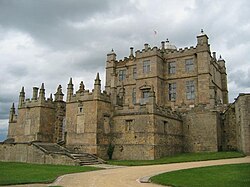 | Bolsover District At the 2011 Census, the district had a population of 75,866. It is named after the town of Bolsover, but the council is based in Clowne, Derbyshire. |
Visit Clowne plaques
 0
0
plaques
here Clowne has 0 physical plaques in tourist plaque schemes for you to explore via Walkfo Clowne plaques audio map when visiting. Plaques like National Heritage’s “Blue Plaques” provide visual geo-markers to highlight points-of-interest at the places where they happened – and Walkfo’s AI has researched additional, deeper content when you visit Clowne using the app. Experience the history of a location when Walkfo local tourist guide app triggers audio close to each Clowne plaque. Currently No Physical Plaques.


 Trying to encourage visitors to Clowne?