Welcome to Visit Cliviger Places
The Walkfo guide to things to do & explore in Cliviger
 Visit Cliviger places using Walkfo for free guided tours of the best Cliviger places to visit. A unique way to experience Cliviger’s places, Walkfo allows you to explore Cliviger as you would a museum or art gallery with audio guides.
Visiting Cliviger Walkfo Preview
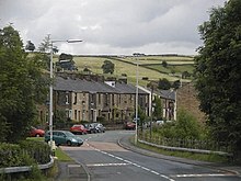
Cliviger is situated to the southeast of Burnley, and northwest of Todmorden . The parish has a population of 2,238 . The principal settlements within the parish are Walk Mill, Southward Bottom, Overtown, Mereclough and Holme Chapel . It is mainly a dormitory area for people working in Burnley and other towns in East Lancashire and West Yorkshire . When you visit Cliviger, Walkfo brings Cliviger places to life as you travel by foot, bike, bus or car with a mobile phone & headphones.
Cliviger Places Overview: History, Culture & Facts about Cliviger
Visit Cliviger – Walkfo’s stats for the places to visit
With 29 audio plaques & Cliviger places for you to explore in the Cliviger area, Walkfo is the world’s largest heritage & history digital plaque provider. The AI continually learns & refines facts about the best Cliviger places to visit from travel & tourism authorities (like Wikipedia), converting history into an interactive audio experience.
Cliviger history
The area has been the site of human habitation for thousands of years. Bronze-Age burial mound is known to exist on Moseley Height above Mereclough. Iron Age gold torc was also found, which is now in the Manchester Museum.
Cliviger geography / climate
The parish is located at the northwestern entrance to Cliviger Gorge, which extends southeast to the (now) West Yorkshire town of Todmorden. The highest point in the parish is Hoof Stones Height on Stiperden Moor to the northeast, at 1,573 feet (479.5 m) above sea level (on the county boundary)
Mereclough

Mereclough is at the junction of Red Lees Road with The Long Causeway . There are two public houses, the Fighting Cocks and the Kettledrum Inn .
Overtown
Overtown is at the junctions of Red Lees Road with Mount Lane and Greencliffe Lane . The parish playing fields and the Jerry Dawson Sports Pavilion are located on Mount Lane .
Walk Mill
Walk Mill is on Burnley Road, where it passes over the River Calder . In 1311 Henry de Lacy held 80 acres of land and a water-mill in Cliviger . A medieval fulling mill (often water-powered) could also be known as a walk mill .
Southward Bottom
Southward Bottom is centered on the junction of Red Lees Road and Burnley Road . River Calder is joined by Easden Clough near Honey Holme farm . In 1840s there was a drift colliery here called the Turner Carr Level .
Holme Chapel

Holme Chapel is on Burnley Road in the centre of the parish (although its most southeasterly settlement) and is regarded as the village centre, with a primary school (St John the Divine C.E. Primary School), St John’s church and the village hall .
Why visit Cliviger with Walkfo Travel Guide App?
 You can visit Cliviger places with Walkfo Cliviger to hear history at Cliviger’s places whilst walking around using the free digital tour app. Walkfo Cliviger has 29 places to visit in our interactive Cliviger map, with amazing history, culture & travel facts you can explore the same way you would at a museum or art gallery with information audio headset. With Walkfo, you can travel by foot, bike or bus throughout Cliviger, being in the moment, without digital distraction or limits to a specific walking route. Our historic audio walks, National Trust interactive audio experiences, digital tour guides for English Heritage locations are available at Cliviger places, with a AI tour guide to help you get the best from a visit to Cliviger & the surrounding areas.
“Curated content for millions of locations across the UK, with 29 audio facts unique to Cliviger places in an interactive Cliviger map you can explore.”
Walkfo: Visit Cliviger Places Map
29 tourist, history, culture & geography spots
Cliviger historic spots | Cliviger tourist destinations | Cliviger plaques | Cliviger geographic features |
| Walkfo Cliviger tourism map key: places to see & visit like National Trust sites, Blue Plaques, English Heritage locations & top tourist destinations in Cliviger | |||
Best Cliviger places to visit
Cliviger has places to explore by foot, bike or bus. Below are a selection of the varied Cliviger’s destinations you can visit with additional content available at the Walkfo Cliviger’s information audio spots:

Church of St Mary of the Assumption, Burnley
The Church of St Mary of the Assumption is in Yorkshire Street, Burnley, Lancashire . It was built between 1846 and 1849 to replace a smaller chapel on a different site . The church is recorded in the National Heritage List for England as a designated Grade II listed building .

Burnley Embankment
The Burnley Embankment carries the Leeds and Liverpool Canal across the Calder and Brun valleys in Burnley, Lancashire . Also known as the Straight Mile, the embankment is 1,256 yards (0.714 mi; 1.148 km) long .

Burnley power station
Burnley power station supplied electricity to the town of Burnley, Lancashire from 1893 to 1958 . The electricity station was owned and operated by Burnley Corporation prior to the nationalisation of the British electricity industry in 1948 .

St Peter’s Church, Burnley
St Peter’s Church is an Anglican church in Burnley, Lancashire . It is an active parish church in the Diocese of Blackburn and the archdeaconry of Blackburn . The oldest part of the church dates from the 15th century, and there are several later additions and restorations .

Burnley Town Hall
Burnley Town Hall is a municipal building in Manchester Road, Burnley, Lancashire . It is the headquarters of Burnley Borough Council . The town hall is a Grade II listed building .

Towneley Park
Towneley Park is owned and managed by Burnley Borough Council . It is the largest and most popular park in Burnley, Lancashire . The main entrance to the park is within a mile of the town centre . The park extends to the south east, covering an area of some 180 hectares .

Towneley Colliery
Towneley Colliery was a coal mine on the Burnley Coalfield in Burnley, Lancashire, England . Sunk in the late 1860s, it was linked by a tramway to the Leeds and Liverpool Canal . The colliery was nationalised in 1947 and closed in 1949 .

Holme Hall, Cliviger
Holme Hall is a Grade II* listed manor house in Cliviger near Burnley, Lancashire. The house dates back to at least the 15th century, was rebuilt in the 17th century and extended in 1854. Between 1985 and 2003 it was used as a retirement home. The structure was devastated by suspected arson attacks in 2003.
Visit Cliviger plaques
 5
5
plaques
here Cliviger has 5 physical plaques in tourist plaque schemes for you to explore via Walkfo Cliviger plaques audio map when visiting. Plaques like National Heritage’s “Blue Plaques” provide visual geo-markers to highlight points-of-interest at the places where they happened – and Walkfo’s AI has researched additional, deeper content when you visit Cliviger using the app. Experience the history of a location when Walkfo local tourist guide app triggers audio close to each Cliviger plaque. Explore Plaques & History has a complete list of Hartlepool’s plaques & Hartlepool history plaque map.


 Trying to encourage visitors to Cliviger?