Welcome to Visit City of Carlisle Places
The Walkfo guide to things to do & explore in City of Carlisle
 Visit City of Carlisle places using Walkfo for free guided tours of the best City of Carlisle places to visit. A unique way to experience City of Carlisle’s places, Walkfo allows you to explore City of Carlisle as you would a museum or art gallery with audio guides.
Visiting City of Carlisle Walkfo Preview
The City of Carlisle is a local government district of Cumbria, England, with the status of a city and non-metropolitan district. In 2011 the district had a population of 107,524, and an area of 1,039.97 square kilometres (402 sq mi) It is named after its largest settlement, Carlisle, but covers a far larger area which includes the towns of Brampton and Longtown, as well as outlying villages including Dalston, Scotby and Wetheral. Carlisle traces its origins to a Roman outpost associated with Hadrian’s Wall. When you visit City of Carlisle, Walkfo brings City of Carlisle places to life as you travel by foot, bike, bus or car with a mobile phone & headphones.
City of Carlisle Places Overview: History, Culture & Facts about City of Carlisle
Visit City of Carlisle – Walkfo’s stats for the places to visit
With 68 audio plaques & City of Carlisle places for you to explore in the City of Carlisle area, Walkfo is the world’s largest heritage & history digital plaque provider. The AI continually learns & refines facts about the best City of Carlisle places to visit from travel & tourism authorities (like Wikipedia), converting history into an interactive audio experience.
City of Carlisle history
The Local Government Act 1972 established the City of Carlisle as a local government district of the new shire county of Cumbria on 1 April 1974. The new dual local authorities had been running since elections in 1973. The act created a two-tier metropolitan and non-metropolitan counties and districts throughout the country.
City of Carlisle geography / climate

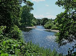
The City of Carlisle is located at the extreme north of North West England. The city is traversed by several major rivers, including the Caldew, Eden, and Petteril. It is bisected by the M6, A74(M) motorways and the Solway Firth, which forms the western section of the Anglo-Scottish border.
Why visit City of Carlisle with Walkfo Travel Guide App?
 You can visit City of Carlisle places with Walkfo City of Carlisle to hear history at City of Carlisle’s places whilst walking around using the free digital tour app. Walkfo City of Carlisle has 68 places to visit in our interactive City of Carlisle map, with amazing history, culture & travel facts you can explore the same way you would at a museum or art gallery with information audio headset. With Walkfo, you can travel by foot, bike or bus throughout City of Carlisle, being in the moment, without digital distraction or limits to a specific walking route. Our historic audio walks, National Trust interactive audio experiences, digital tour guides for English Heritage locations are available at City of Carlisle places, with a AI tour guide to help you get the best from a visit to City of Carlisle & the surrounding areas.
“Curated content for millions of locations across the UK, with 68 audio facts unique to City of Carlisle places in an interactive City of Carlisle map you can explore.”
Walkfo: Visit City of Carlisle Places Map
68 tourist, history, culture & geography spots
City of Carlisle historic spots | City of Carlisle tourist destinations | City of Carlisle plaques | City of Carlisle geographic features |
| Walkfo City of Carlisle tourism map key: places to see & visit like National Trust sites, Blue Plaques, English Heritage locations & top tourist destinations in City of Carlisle | |||
Best City of Carlisle places to visit
City of Carlisle has places to explore by foot, bike or bus. Below are a selection of the varied City of Carlisle’s destinations you can visit with additional content available at the Walkfo City of Carlisle’s information audio spots:
| University of Cumbria The University of Cumbria opened its doors in 2007. It has its headquarters in Carlisle and other major campuses in Lancaster, Ambleside, and London. |
 | Cumbria House Cumbria House is a municipal building in Botchergate, Carlisle. It is the headquarters of the Cumbrian County Council. |
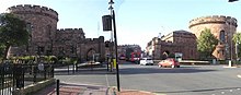 | Carlisle Citadel Carlisle Citadel or The Citadel is a former medieval fortress on English Street in Carlisle, Cumbria. It comprises two towers, the Nisi Prius Courthouse and the former Crown Court. |
 | Carlisle Civic Centre Carlisle Civic Centre is a municipal building in Carlisle, England. It is located in the Rickergate, Carlisle. The Civic Centre was built in the 1960s. |
 | Old Town Hall, Carlisle The Old Town Hall is a Grade I listed building in Carlisle, England. It is a municipal building in the Market Place, Carlisle. |
 | Carlisle Guildhall Carlisle Guildhall is an historic building in Carlisle, Cumbria. It is a Grade I listed building, listed on 1 June 1949. The upper floors now house a museum. |
 | Carlisle Tithe Barn Carlisle Tithe Barn is an historic building in Carlisle, Cumbria. It is Grade I listed building, listed on 1 June 1949. |
 | Milecastle 65 Milecastle 65 (Tarraby) was a milecastle on Hadrian’s Wall (grid reference NY40855793) Mile Castle 65 was located in Tarraby. |
 | Milecastle 66 Milecastle 66 (Stanwix Bank) was a milecastle on Hadrian’s Wall (grid reference NY39735678) Milecastle was built in the early Roman era. |
 | Hadrian’s Camp Hadrian’s Camp was a military installation on the line of Hadrian’s Wall at Houghton in Cumbria, England. |
Visit City of Carlisle plaques
 4
4
plaques
here City of Carlisle has 4 physical plaques in tourist plaque schemes for you to explore via Walkfo City of Carlisle plaques audio map when visiting. Plaques like National Heritage’s “Blue Plaques” provide visual geo-markers to highlight points-of-interest at the places where they happened – and Walkfo’s AI has researched additional, deeper content when you visit City of Carlisle using the app. Experience the history of a location when Walkfo local tourist guide app triggers audio close to each City of Carlisle plaque. Explore Plaques & History has a complete list of Hartlepool’s plaques & Hartlepool history plaque map.


 Trying to encourage visitors to City of Carlisle?