Welcome to Visit Cirencester Places
The Walkfo guide to things to do & explore in Cirencester
 Visit Cirencester places using Walkfo for free guided tours of the best Cirencester places to visit. A unique way to experience Cirencester’s places, Walkfo allows you to explore Cirencester as you would a museum or art gallery with audio guides.
Visiting Cirencester Walkfo Preview
Cirencester is a market town 80 miles (130 km) west of London. It lies on the River Churn, a tributary of the River Thames. It is the home of the Royal Agricultural University, the oldest agricultural college in the English-speaking world, founded in 1840. The Roman name for the town was Corinium, which is thought to have been associated with the ancient British tribe of the Dobunni. When you visit Cirencester, Walkfo brings Cirencester places to life as you travel by foot, bike, bus or car with a mobile phone & headphones.
Cirencester Places Overview: History, Culture & Facts about Cirencester
Visit Cirencester – Walkfo’s stats for the places to visit
 With 22 audio plaques & Cirencester places for you to explore in the Cirencester area, Walkfo is the world’s largest heritage & history digital plaque provider. The AI continually learns & refines facts about the best Cirencester places to visit from travel & tourism authorities (like Wikipedia), converting history into an interactive audio experience.
Cirencester history
Roman Corinium
Cirencester is known to have been an important early Roman area, along with St. Albans and Colchester. The Romans built a fort where the Fosse Way crossed the Churn, to hold two quingenary alae tasked with helping to defend the provincial frontier around AD 49. When the frontier moved to the north after the conquest of Wales, this fort was closed and its fortifications levelled around the year 70, but the town persisted and flourished under the name Corinium.
Post-Roman and Saxon

The Roman amphitheatre still exists in an area known as the Querns to the south-west of the town. Possibly this was the palace of one of the British kings defeated by Ceawlin in 577. It was later the scene of the Battle of Cirencester, this time between the Mercian king Penda and the West Saxon kings Cynegils and Cwichelm in 628.
Norman
At the Norman Conquest the royal manor of Cirencester was granted to the Earl of Hereford, William Fitz-Osbern, but by 1075 it had reverted to the Crown. The townspeople were amerced for a false presentment, meaning that they had presented false information. The struggle of the townsmen to gain the rights and privileges of a borough for Cirenceter probably began in the same year.
Tudor
As part of the Dissolution of the Monasteries in 1539, Henry VIII ordered the total demolition of the Abbey buildings. Today only the Norman Arch and parts of the precinct wall remain above ground, forming the perimeter of a public park in the middle of town.
Civil War
The English Civil War came to Cirencester in February 1643 when Royalists and Parliamentarians came to blows in the streets. Over 300 were killed and 1,200 prisoners were held captive in the church. The townsfolk supported the Parliamentarians but gentry and clergy were for the old order.
Recent history
At the end of the 18th century, Cirencester was a thriving market town at the centre of a network of turnpike roads with easy access to markets for its produce of grain and wool. In 1789, the opening of the Thames and Severn Canal provided. In 1841, a branch railway line was opened to Kemble to provide a link to the Great Western Railway at Swindon. The loss of the canal and the direct rail link encouraged dependency on road transport.
Cirencester culture & places
The Sundial Theatre, part of Cirencester College the Bingham Hall and the Barn Theatre host drama and musical events. Community groups and professional companies are also based in the town.
Why visit Cirencester with Walkfo Travel Guide App?
 You can visit Cirencester places with Walkfo Cirencester to hear history at Cirencester’s places whilst walking around using the free digital tour app. Walkfo Cirencester has 22 places to visit in our interactive Cirencester map, with amazing history, culture & travel facts you can explore the same way you would at a museum or art gallery with information audio headset. With Walkfo, you can travel by foot, bike or bus throughout Cirencester, being in the moment, without digital distraction or limits to a specific walking route. Our historic audio walks, National Trust interactive audio experiences, digital tour guides for English Heritage locations are available at Cirencester places, with a AI tour guide to help you get the best from a visit to Cirencester & the surrounding areas.
“Curated content for millions of locations across the UK, with 22 audio facts unique to Cirencester places in an interactive Cirencester map you can explore.”
Walkfo: Visit Cirencester Places Map
22 tourist, history, culture & geography spots
Cirencester historic spots | Cirencester tourist destinations | Cirencester plaques | Cirencester geographic features |
| Walkfo Cirencester tourism map key: places to see & visit like National Trust sites, Blue Plaques, English Heritage locations & top tourist destinations in Cirencester | |||
Best Cirencester places to visit
Cirencester has places to explore by foot, bike or bus. Below are a selection of the varied Cirencester’s destinations you can visit with additional content available at the Walkfo Cirencester’s information audio spots:
 | Cecily Hill Barracks Cecily Hill Barracks is a former military installation in Cirencester in Gloucestershire. The former keep for the barracks stands at the entrance to Cirenceter Park. |
 | Cirencester Park (country house) Cirencester Park is the seat of the Bathurst family, Earls Bathurst. It is a Grade II* listed building. The gardens are Grade I listed on the Register of Historic Parks and Gardens. |
| Cirencester Cirencester is a market town 80 miles (130 km) west of London. It lies on the River Churn, a tributary of the River Thames. It is the home of the Royal Agricultural University, the oldest agricultural college in the English-speaking world, founded in 1840. The Roman name for the town was Corinium, which is thought to have been associated with the ancient British tribe of the Dobunni. |
 | Stratton, Gloucestershire Stratton is a village, ward and former civil parish about 22 miles from Gloucester. In 1931 the parish had a population of 963. In 2018 the built up area and ward had an estimated population of 2584. |
| Cirencester Town F.C. Cirencester Town Football Club is a football club based in Citencester, Gloucestershire, England. The club are currently members of the Southern League Division One South and play at the Corinium Stadium. |
 | Ampney Park Ampney Park is a 16th century manor house at Ampney Crucis, Gloucestershire, England. It is a Grade II listed building. |
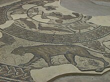 | Corinium Dobunnorum Corinium Dobunnorum was the Romano-British settlement at Cirencester in the present-day English county of Gloucestershire. Its 2nd-century walls enclosed the second-largest area of a city in Roman Britain. It is usually thought to have been the capital of the Diocletian-era province of First Britain. |
Visit Cirencester plaques
 6
6
plaques
here Cirencester has 6 physical plaques in tourist plaque schemes for you to explore via Walkfo Cirencester plaques audio map when visiting. Plaques like National Heritage’s “Blue Plaques” provide visual geo-markers to highlight points-of-interest at the places where they happened – and Walkfo’s AI has researched additional, deeper content when you visit Cirencester using the app. Experience the history of a location when Walkfo local tourist guide app triggers audio close to each Cirencester plaque. Explore Plaques & History has a complete list of Hartlepool’s plaques & Hartlepool history plaque map.


 Trying to encourage visitors to Cirencester?