Welcome to Visit Chorlton-cum-Hardy Places
The Walkfo guide to things to do & explore in Chorlton-cum-Hardy
 Visit Chorlton-cum-Hardy places using Walkfo for free guided tours of the best Chorlton-cum-Hardy places to visit. A unique way to experience Chorlton-cum-Hardy’s places, Walkfo allows you to explore Chorlton-cum-Hardy as you would a museum or art gallery with audio guides.
Visiting Chorlton-cum-Hardy Walkfo Preview
When you visit Chorlton-cum-Hardy, Walkfo brings Chorlton-cum-Hardy places to life as you travel by foot, bike, bus or car with a mobile phone & headphones.
Chorlton-cum-Hardy Places Overview: History, Culture & Facts about Chorlton-cum-Hardy
Visit Chorlton-cum-Hardy – Walkfo’s stats for the places to visit
With 177 audio plaques & Chorlton-cum-Hardy places for you to explore in the Chorlton-cum-Hardy area, Walkfo is the world’s largest heritage & history digital plaque provider. The AI continually learns & refines facts about the best Chorlton-cum-Hardy places to visit from travel & tourism authorities (like Wikipedia), converting history into an interactive audio experience.
Chorlton-cum-Hardy history
Toponymy
Chorlton probably means Ceolfrith’s farm or settlement from Old English personal name and tūn, an enclosure, farmstead or village . Hardy is derived from a personal name, Hearda, and ēg, Anglian for island or dry ground in a well-watered land . It has alternatively been suggested that Hardy may mean “by the woods”, in reference to the ancient forest of Arden Wood .
Early history
The district was part of the kingdom of Northumbria from the 7th century . Settlement in the Mersey valley may well have been later . Thomas L. Ellwood suggested 610 AD as the date of founding the settlement .
Suburban growth

Until the last quarter of the 19th century, Chorlton’s population had increased slowly . When the railway reached neighbouring Stretford in 1849, upmarket villas were built on a flood-free area in Edge Lane and High Lane . Wilbraham Road was built in 1869 to connect the Egerton holdings across Withington from Edge Lane to Fallowfield .
Chorlton-cum-Hardy culture & places
There are three amateur dramatic societies that rehearse and perform in Chorlton. A number of poets and minor publishers of poetry were active in the late 20th century.
Cinemas and dance halls
Chorlton Pavilion bought by H. D. Moorhouse in 1909 and Palais de Luxe in 1915 . Rivoli opened on Barlow Moor Road in 1936 and changed its name several times to the Essoldo, the Classic and the Shalimar . Majestic on Manchester Road had several names, the Savoy, the ABC and the Gaumont .
Creative and performing arts
Until October 2009 Chorlton was the location for Cosgrove Hall animation studios . The studios were used for children’s series such as The BFG and The Wind in the Willows . The area is used by film crews for TV locations such as White Van Man .
Chorlton-cum-Hardy landmarks
Manchester City Council designated Chorlton Green a conservation area in 1970 and Chorrtonville in 1991. The area was designated as a conservation site by the council in 1991 and a conservation park in 1970.
Chorlton Library

Chorlton Library was built in 1914 to a design by Manchester City Council architect Henry Price . It was funded by a £5000 donation from steel magnate and philanthropist Andrew Carnegie . It is one of about 3000 Carnegie libraries around the world .
Southern Cemetery
Southern Cemetery originally occupied 40 acres of land that cost Manchester Corporation £38,340 in 1872 . The cemetery opened on 9 October 1879 and had mortuary chapels for Anglicans, Nonconformists, and Roman Catholics linked by an elliptical drive and a Jewish chapel at the west corner of the site .
Chorlton-cum-Hardy geography / climate
The ancient township of Chorlton cum Hardy covered 1,280 acres (520 ha) of low-lying, flat land on the north bank of the River Mersey. In medieval times the district formed part of the Manor of Withington, an area stretching from Longford Park to Debdale Park. The highest land is at the south-east end, where it reaches a little over 100 feet (30 m) OD.
Why visit Chorlton-cum-Hardy with Walkfo Travel Guide App?
 You can visit Chorlton-cum-Hardy places with Walkfo Chorlton-cum-Hardy to hear history at Chorlton-cum-Hardy’s places whilst walking around using the free digital tour app. Walkfo Chorlton-cum-Hardy has 177 places to visit in our interactive Chorlton-cum-Hardy map, with amazing history, culture & travel facts you can explore the same way you would at a museum or art gallery with information audio headset. With Walkfo, you can travel by foot, bike or bus throughout Chorlton-cum-Hardy, being in the moment, without digital distraction or limits to a specific walking route. Our historic audio walks, National Trust interactive audio experiences, digital tour guides for English Heritage locations are available at Chorlton-cum-Hardy places, with a AI tour guide to help you get the best from a visit to Chorlton-cum-Hardy & the surrounding areas.
“Curated content for millions of locations across the UK, with 177 audio facts unique to Chorlton-cum-Hardy places in an interactive Chorlton-cum-Hardy map you can explore.”
Walkfo: Visit Chorlton-cum-Hardy Places Map
177 tourist, history, culture & geography spots
Chorlton-cum-Hardy historic spots | Chorlton-cum-Hardy tourist destinations | Chorlton-cum-Hardy plaques | Chorlton-cum-Hardy geographic features |
| Walkfo Chorlton-cum-Hardy tourism map key: places to see & visit like National Trust sites, Blue Plaques, English Heritage locations & top tourist destinations in Chorlton-cum-Hardy | |||
Best Chorlton-cum-Hardy places to visit
Chorlton-cum-Hardy has places to explore by foot, bike or bus. Below are a selection of the varied Chorlton-cum-Hardy’s destinations you can visit with additional content available at the Walkfo Chorlton-cum-Hardy’s information audio spots:

Hough End Hall
Hough End Hall is a historic house now in Chorlton-cum-Hardy, (originally in Withington), Manchester . It was built in 1596 during the reign of Queen Elizabeth I by Sir Nicholas Mosley . The Mosleys were an influential Mancunian family from the 16th century onwards .

Chorlton Poor Law Union
Chorlton Poor Law Union was founded in January 1837 in response to the Poor Law Amendment Act 1834 . It was overseen by an elected board of 19 guardians representing the 12 parishes in the area it served .

Southern Cemetery, Manchester
Southern Cemetery is a large municipal cemetery in Chorlton-cum-Hardy, Manchester, England . It opened in 1879 and is owned and administered by Manchester City Council . It is the second largest cemetery in Europe and the largest in the UK .

St Ann’s, Stretford
St Ann’s Church, Stretford is a Grade II listed Roman Catholic church . It was constructed between 1862 and 1863, on the east side of the A56 Chester Road . The parish functions under the jurisdiction of the Roman Catholic Diocese of Salford .
![]()
Centre for Pharmacy Postgraduate Education
The Centre for Pharmacy Postgraduate Education (CPPE) is part of the Manchester Pharmacy School, in the University of Manchester . In May 1991, CPPE was created as a direct response to the perceived lack of continuing professional development support given to community pharmacists .
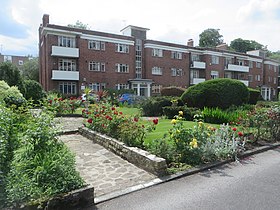
Appleby Lodge
Appleby Lodge is a set of three-storey 1930s blocks of flats with eight entrance doors . The blocks are in a U-shape around a central garden in Rusholme, Manchester .
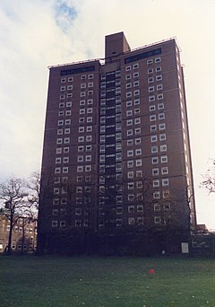
Owens Park
Owens Park is a large hall of residence located in the Fallowfield district of the city of Manchester . The hall is owned by the University of Manchester and houses 1,056 students . The terms ‘Owens Park’ and ‘Fallowfield Campus’ are sometimes used interchangeably .

Municipal Borough of Stretford
Stretford was, from 1868 to 1974, a local government district coterminate with the town of Stretford, Lancashire.
Municipal Borough of Sale
Sale was, from 1867 to 1974, a district in Cheshire. The district had the status of local government district, urban district and municipal borough. Its area now forms part of the Metropolitan Borough of Trafford.
![]()
Real Radio XS
Real Radio XS was a radio station brand operated by Real and Smooth Ltd (formerly GMG Radio) based in Salford, Greater Manchester, broadcasting a variety of peak-time news, rock music and talk output. The Manchester-based version of the service was broadcast to Greater Manchester on FM, and to a number of areas on DAB.
Visit Chorlton-cum-Hardy plaques
 56
56
plaques
here Chorlton-cum-Hardy has 56 physical plaques in tourist plaque schemes for you to explore via Walkfo Chorlton-cum-Hardy plaques audio map when visiting. Plaques like National Heritage’s “Blue Plaques” provide visual geo-markers to highlight points-of-interest at the places where they happened – and Walkfo’s AI has researched additional, deeper content when you visit Chorlton-cum-Hardy using the app. Experience the history of a location when Walkfo local tourist guide app triggers audio close to each Chorlton-cum-Hardy plaque. Explore Plaques & History has a complete list of Hartlepool’s plaques & Hartlepool history plaque map.


 Trying to encourage visitors to Chorlton-cum-Hardy?