Welcome to Visit Chester-le-Street Places
The Walkfo guide to things to do & explore in Chester-le-Street
 Visit Chester-le-Street places using Walkfo for free guided tours of the best Chester-le-Street places to visit. A unique way to experience Chester-le-Street’s places, Walkfo allows you to explore Chester-le-Street as you would a museum or art gallery with audio guides.
Visiting Chester-le-Street Walkfo Preview
Chester-le-Street is a market town and civil parish north of the River Wear. It is located 7 miles (11 km) south of Newcastle upon Tyne and 8 miles (13 km) west of Sunderland. The Roman fort is the “Chester” (from the Latin castra) of the town’s name. When you visit Chester-le-Street, Walkfo brings Chester-le-Street places to life as you travel by foot, bike, bus or car with a mobile phone & headphones.
Chester-le-Street Places Overview: History, Culture & Facts about Chester-le-Street
Visit Chester-le-Street – Walkfo’s stats for the places to visit
With 42 audio plaques & Chester-le-Street places for you to explore in the Chester-le-Street area, Walkfo is the world’s largest heritage & history digital plaque provider. The AI continually learns & refines facts about the best Chester-le-Street places to visit from travel & tourism authorities (like Wikipedia), converting history into an interactive audio experience.
Chester-le-Street history
Chester-le-Street was the centre of Christianity for much of the northeast because it was the seat of the Bishop of Lindisfarne. The Roman fort of Concangis was built alongside the Roman road Cade’s Road (now Front Street) and close to the River Wear. After the Romans left there is no record of who lived there (apart from some wounded soldiers from wars who had to live there) until 883 when a group of monks stopped there to build a wooden shrine and church to St Cuthbert.
Chester-le-Street landmarks

John Leland described Chester-le-Street in the 1530s as “Chiefly one main street of very mean building in height”
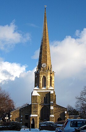
St Mary and St Cuthbert church
St Mary and St Cuthbert is Chester-le-Street’s only Grade I listed building. It was built for an anchorite, an extreme form of hermit. The north aisle is occupied by a line of Lumley family effigies assembled circa 1590.
Chester Burn viaduct
Viaduct to the northwest of the town centre was completed in 1868 for the North Eastern Railway. It is over 230m long with 11 arches, now spanning a road and supermarket car-park.
Lumley Castle
Lumley Castle was built in 1388. It sits upon the eastern bank of the River Wear and overlooks the town and Riverside Park.
Bethel United Reformed church
The small United Reformed Church on Low Chare, just off the main Front Street, was built in 1814 as the Bethel Congregational Chapel and remodelled in 1860. It is still in use and is a Grade II listed building.
The Queens Head Hotel
The Queens Head Hotel was built over 250 years ago when this road was the main route from Edinburgh and Newcastle to the south and London. It is still one of the largest buildings in the street and so the town centre, and is a Grade II listed building.
The Post Office
Chester-le-Street Post Office at 137 Front Street is in the Art Deco style and replaced a smaller building located on the corner of Relton Terrace and Ivanhoe Terrace. It is one of a handful of post offices that display the royal cypher from the brief reign of Edward VIII.
Why visit Chester-le-Street with Walkfo Travel Guide App?
 You can visit Chester-le-Street places with Walkfo Chester-le-Street to hear history at Chester-le-Street’s places whilst walking around using the free digital tour app. Walkfo Chester-le-Street has 42 places to visit in our interactive Chester-le-Street map, with amazing history, culture & travel facts you can explore the same way you would at a museum or art gallery with information audio headset. With Walkfo, you can travel by foot, bike or bus throughout Chester-le-Street, being in the moment, without digital distraction or limits to a specific walking route. Our historic audio walks, National Trust interactive audio experiences, digital tour guides for English Heritage locations are available at Chester-le-Street places, with a AI tour guide to help you get the best from a visit to Chester-le-Street & the surrounding areas.
“Curated content for millions of locations across the UK, with 42 audio facts unique to Chester-le-Street places in an interactive Chester-le-Street map you can explore.”
Walkfo: Visit Chester-le-Street Places Map
42 tourist, history, culture & geography spots
Chester-le-Street historic spots | Chester-le-Street tourist destinations | Chester-le-Street plaques | Chester-le-Street geographic features |
| Walkfo Chester-le-Street tourism map key: places to see & visit like National Trust sites, Blue Plaques, English Heritage locations & top tourist destinations in Chester-le-Street | |||
Best Chester-le-Street places to visit
Chester-le-Street has places to explore by foot, bike or bus. Below are a selection of the varied Chester-le-Street’s destinations you can visit with additional content available at the Walkfo Chester-le-Street’s information audio spots:
 | Pelton, County Durham Pelton is a village and electoral ward in County Durham. The population of the village and ward taken at the 2011 census was 8,250. It is located about two miles to the northwest of Chester-le-Street. Pelton has a newly built community centre updated in 2012. |
 | St Mary and St Cuthbert, Chester-le-Street The parish church of St Mary and St Cuthbert is a Church of England church in Chester-le-Street, County Durham. The site has been used for worship for over 1100 years; elements of the current building are over 950 years old. The oldest surviving translation of the Gospels into English was done here by Aldred between 947 and 968. |
 | Ropery Lane Chester-le-Street Cricket Club play in the North East Premier League. The ground has hosted three first-class matches and eight List A matches. Durham County Cricket Club played six Gillette Cup/Natwest Trophy matches at Ropery Lane. |
 | Durham Coalfield The Durham and Northumberland Coalfield is a coalfield in north-east England. It extends from Bishop Auckland in the south to the boundary with Northumberlands along the River Tyne in the north. |
 | Chester-le-Street Town F.C. Chester-le-Street Town Football Club is a football club based in County Durham, England. They are currently members of the Northern League Division Two and play at Moor Park. |
 | Biddick Hall (house) Biddick Hall is a small privately owned 18th-century country mansion at Bournmoor, County Durham. It is a Grade I listed building and the home of the Lambton family. |
 | Lambton Castle Lambton Castle is the ancestral seat of the Lambton family, the Earls of Durham. It is listed in the mid-category of listed building, Grade II*. |
 | Waldridge Fell Waldridge Fell is one of the largest areas of lowland heath in County Durham. It contains the only lowland valley-mire in the county. The fell is home to a number of plants and insects that are scarce to rare elsewhere. |
Visit Chester-le-Street plaques
 0
0
plaques
here Chester-le-Street has 0 physical plaques in tourist plaque schemes for you to explore via Walkfo Chester-le-Street plaques audio map when visiting. Plaques like National Heritage’s “Blue Plaques” provide visual geo-markers to highlight points-of-interest at the places where they happened – and Walkfo’s AI has researched additional, deeper content when you visit Chester-le-Street using the app. Experience the history of a location when Walkfo local tourist guide app triggers audio close to each Chester-le-Street plaque. Currently No Physical Plaques.


 Trying to encourage visitors to Chester-le-Street?