Welcome to Visit Chell, Staffordshire Places The Walkfo guide to things to do & explore in Chell, Staffordshire
Visit Chell, Staffordshire places using Walkfo for free guided tours of the best Chell, Staffordshire places to visit. A unique way to experience Chell, Staffordshire’s places, Walkfo allows you to explore Chell, Staffordshire as you would a museum or art gallery with audio guides.
Visiting Chell, Staffordshire Walkfo Preview Chell is a suburb of Stoke-on-Trent in Staffordshire, England. It lies on the northern edge of the city, approximately 1-mile (1.6 km) from Tunstall. It borders Pitts Hill to the west, Tunstall to the south west, Stanfield and Bradeley. When you visit Chell, Staffordshire, Walkfo brings Chell, Staffordshire places to life as you travel by foot, bike, bus or car with a mobile phone & headphones.
Visit Chell, Staffordshire – Walkfo’s stats for the places to visit
With 57 audio plaques & Chell, Staffordshire places for you to explore in the Chell, Staffordshire area, Walkfo is the world’s largest heritage & history digital plaque provider. The AI continually learns & refines facts about the best Chell, Staffordshire places to visit from travel & tourism authorities (like Wikipedia), converting history into an interactive audio experience.
Chell, Staffordshire history
There is no mention of Chell in the Domesday Book, it is believed to have come under the lands of Wolstanton. The earliest written record of Chell comes from 1212, by which time Chell had already been split into Little and Great Chell. Prior to 1212 the lord of the manor was Adam de Audley. He was succeeded by his son Henry de Audley who in 1212 confirmed in writing his father’s decision to award one third of Chell to Robert Blund when giving him a further 14 acres ‘in the wood between Chell and Thunstal’. Henry de Audley later gave the remaining two-thirds of Chell to Richard of Hanley, who is recorded under the name Richard Chell c.1230. Chell is now a common family name in north Staffordshire. There are few records of Little Chell manor after 1344 suggesting it had merged with Great Chell manor. However, the earliest confirmation of this is in 1679 when the Sneyd family, owners of Great Chell Manor, are known to have also taken over Little Chell Manor. The Sneyd family held these manors into the 19th century. William Henry Duignan traced the etymology of Chell back to Ceolegh. “Ceole” meant throat or narrow valley in Old English and Chell is situated at the edge of a ridge of land by a narrow valley. Another possibility is that the township was named after a person known as Ceol- Ceol’s Lea, lea meaning meadow. In 1666 surveys conducted for the then recently implemented Hearth Tax recorded a total of ten households in Chell as being liable for payment of the tax on a total of 15 hearths. No households were recorded as being too poor to pay the tax. Chell receives a mention in William White’s 1851 History, gazetteer, and directory of Staffordshire: “CHELL (GREAT AND LITTLE) form a liberty of 740 acres and 737 souls. Great Chell is on an eminence 2 ½ N. by E. of Burslem, and is occupied chiefly by potters. The Primitive Methodists have a chapel here, built in 1823, and enlarged in 1830 and 1841. The Union Workhouse is at Great Chell.” Twenty years later Chell receive another mention in John Marius Wilson’s grander Imperial Gazetteer of England and Wales, compiled 1870–72: “CHELL, a township in Wolstanton parish, Stafford; 2 miles north of Burslem. Population, 1219. Houses, 215. It contains the Wolstanton and Burslem workhouse; and its inhabitants are chiefly colliers and potterers.” In 1772 the celebrated canal engineer James Brindley died at his home, Turnhurst Hall, on what is now Turnhust Road, Great Chell. Little Chell Water-Mill is first mentioned in 1539, as having belonged to the Colclough family for several generations. It is believed to have been situated on Scotia Brook, where it enters what is now Victoria Park, and ground corn. In 1757 the then owner, Thomas Baddeley of Newfield, contracted James Brindley to fit the mill with machinery for grinding flint and also pumping water out of a neighbouring mine. By 1832 the water-mill had been decommissioned and demolished, only the attached farmstead remained. Chell Lodge, on the south side of Little Chell Lane, also known as Little Chell Hall, was built by wealthy potter Thomas Cartlich in the late 1830s. It was demolished in the 1920s to make way for the houses on Sproston and Scott Roads. Sited on the north side of Little Chell Lane, was Little Chell Farm, first documented in 1775. Blessed William Southern Roman Catholic County Secondary was built on this site in 1957 and was renamed St Margaret Ward’s Catholic School in 1970. The school was renamed St Margaret Ward Catholic Academy in 2013. The Local Government Act 1894 put Chell under Wolstanton Rural District from its creation in 1895 to its abolition in 1904. Parts of Great Chell had by then already been transferred to Tunstall Urban District Council. Little Chell and Chell Heath were transferred to Smallthorne Urban District, which did not join the federation of Stoke-on-Trent until 1922, making Chell one of the last additions to Stoke-on-Trent. Barnett Grove and Stross Avenue, in Little Chell, off Little Chell Lane are named after Barnett Stross a former city councillor and MP for Hanley constituency from 1945 to 1950, and its replacement Stoke-on-Trent Central from 1950 to 1966. He is noted for founding and championing the global Lidice Shall Live campaign that sought to raise awareness of, and rebuild, the Czech village of Lidice, destroyed by the Nazis in 1942 in revenge for Reinhard Heydrich’s murder by British trained Czechs. Chatterley Whitfield Colliery is a disused coal-mine on the eastern outskirts of Chell. It was the largest mine in North Staffordshire and in 1937 it became the first colliery in the UK to produce 1,000,000 tons of saleable coal in a year. In 1976 coal drawing at Chatterley Whitfield came to an end, with the coal worked from Wolstanton Colliery, via a four-mile underground passageway, until it too closed in 1981. On 28 April 2014, Greene King Brewery opened a new £4.5m pub named The Chatterley Whitfield on the western outskirts of Chell.
Chell Workhouse
The Wolstanton And Burslem Union Workhouse was opened in 1839 at a cost of £6,900 to house 400 inmates. The workhouse remained in use beyond the Federation of Stoke-on-Trent whereupon the newly formed county borough took over the running of the facility. It finally closed in 1922, eight years before the workhouse system was abolished by act of parliament.
Why visit Chell, Staffordshire with Walkfo Travel Guide App?
You can visit Chell, Staffordshire places with Walkfo Chell, Staffordshire to hear history at Chell, Staffordshire’s places whilst walking around using the free digital tour app. Walkfo Chell, Staffordshire has 57 places to visit in our interactive Chell, Staffordshire map, with amazing history, culture & travel facts you can explore the same way you would at a museum or art gallery with information audio headset. With Walkfo, you can travel by foot, bike or bus throughout Chell, Staffordshire, being in the moment, without digital distraction or limits to a specific walking route. Our historic audio walks, National Trust interactive audio experiences, digital tour guides for English Heritage locations are available at Chell, Staffordshire places, with a AI tour guide to help you get the best from a visit to Chell, Staffordshire & the surrounding areas.
“Curated content for millions of locations across the UK, with 57 audio facts unique to Chell, Staffordshire places in an interactive Chell, Staffordshire map you can explore.”
Walkfo Chell, Staffordshire tourism map key: places to see & visit like National Trust sites, Blue Plaques, English Heritage locations & top tourist destinations in Chell, Staffordshire
Best Chell, Staffordshire places to visit
Chell, Staffordshire has places to explore by foot, bike or bus. Below are a selection of the varied Chell, Staffordshire’s destinations you can visit with additional content available at the Walkfo Chell, Staffordshire’s information audio spots:
Norton United F.C. Norton United F.C. was a football club based in Smallthorne, Stoke-on-Trent, Staffordshire. They were established in 1989 and joined the Staffordshire Senior League in the same year. The club’s ground was the Norton Cricket Club & Miners Welfare Institute; however’ they left that ground mid season due to contractual issues with the owners and played their remaining fixtures at Lyme Valley Stadium.
Whitfield Valley Whitfield Valley is a local nature reserve on the northern fringe of Stoke-on-Trent, England. The nature reserve is located on the north edge of the city.
Brown Edge Brown Edge is a village and civil parish in Staffordshire Moorlands district of Staffordshire. According to the 2001 census it had a population of 2,406, increasing to 2,486 at the 2011 Census. The village is on the fringe of The Potteries Urban Area, and is about 5 miles north-east of Hanley in Stoke-on-Trent.
Queen’s Theatre, Burslem The Queen’s Theatre (originally Queen’s Hall) is a Grade II listed building in Burslem, Stoke-on-Trent. It is situated in Wedgwood Place in the town centre.
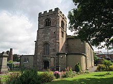
St John the Baptist’s Church, Burslem St John the Baptist’s Church is an Anglican church in Burslem, Stoke-on-Trent, Staffordshire. It is a Grade II listed building.
Old Town Hall, Burslem The Old Town Hall is a Grade II* listed building in Burslem, Staffordshire. It is in the Market Place, in the centre of the town.
Middleport Pottery Middleport Pottery was built in 1888 by Burgess & Leigh Ltd (founders William Leigh and Frederick Rathbone Burgess) It is located at Middleport, Stoke-on-Trent, England.
Golden Torch The Golden Torch, more commonly known as The Torch, was a nightclub in Tunstall, Stoke-on-Trent, England. Opened as a mod venue, it later became important to fans of Northern soul. Peter Stringfellow was among the many DJs who had a residency there.
Christ Church, Tunstall Christ Church is an Anglican church in Tunstall, Stoke-on-Trent, Staffordshire. It is the parish church of Goldenhill and Tunstall; the combined parish, which is an Anglo-Catholic parish, was created in 2010. The church is a Grade II listed building.
St Anne’s Church, Brown Edge St Anne’s Church is an Anglican church in Brown Edge, Staffordshire, and in the Diocese of Lichfield. The building is Grade II listed.
Visit Chell, Staffordshire plaques
3 plaques hereChell, Staffordshire has 3 physical plaques in tourist plaque schemes for you to explore via Walkfo Chell, Staffordshire plaques audio map when visiting. Plaques like National Heritage’s “Blue Plaques” provide visual geo-markers to highlight points-of-interest at the places where they happened – and Walkfo’s AI has researched additional, deeper content when you visit Chell, Staffordshire using the app. Experience the history of a location when Walkfo local tourist guide app triggers audio close to each Chell, Staffordshire plaque. Explore Plaques & History has a complete list of Hartlepool’s plaques & Hartlepool history plaque map.
Walkfo guides for things to do / places to visit in Chell, Staffordshire allows exploration as you would do an art gallery or museum. Walk close to one of Chell, Staffordshire’s 57 historic places & our digital tour guide will create an audio story for that spot. With headphone connected, you can explore Chell, Staffordshire freely by foot, bike or bus – with your own personal tour guide in your pocket.
Explore Chell, Staffordshire Map App
Our visit Chell, Staffordshire map shows you things-to-do & places you can visit in Chell, Staffordshire & surrounding areas using the Walkfo digital audio tour guide app. Each spot has plaque, building, street or area information on history, culture or tourism.
You can set your Walkfo’s Chell, Staffordshire tourist map to find historic & tourism spots within 1km, 3km & 5km of the Chell, Staffordshire centre, depending on how far you plan to explore whilst you visit Chell, Staffordshire area at LONG:-2.1964, LAT:53.0715.
Walkfo App
Walkfo
Walkfo is free to download & use (for a limited time period), so if you are looking to explore Chell, Staffordshire, go to your App Store to search for “Walkfo” or follow a links below and install on your mobile phone. Walkfo is designed for use with headphones or AirPods, so you can walk & explore whilst learning about the things around you without digital distraction.
Things to do & visit in Chell, Staffordshire / surrounding areas
● Baddeley Green ● Norton Green, Stoke-on-Trent ● Ball Green ● Norton le Moors ● Ford Green Hall ● Norton United F.C. ● Smallthorne ● Smallthorne Urban District ● Holden Viaduct ● Ridgeway, Staffordshire ● Bradeley ● Whitfield Valley ● Brown Edge ● Sneyd Colliery Disaster ● Vale Park ● Port Vale F.C. ● Cobridge ● Queen’s Theatre, Burslem ● Wedgwood Institute ● St John the Baptist’s Church, Burslem ● Old Town Hall, Burslem ● Ceramica ● The Duke William, Stoke-on-Trent ● Pinnox branch ● Middleport, Staffordshire ● Longport, Staffordshire ● Middleport Pottery ● Westport Lake, Stoke-on-Trent ● Pitts Hill ● Golden Torch
● Christ Church, Tunstall ● Chell, Staffordshire ● Chatterley Whitfield ● Sandyford, Staffordshire ● Turnhurst ● Bradwell, Staffordshire ● Kidsgrove ● Kidsgrove Athletic F.C. ● Hardings Wood Junction ● Hall Green Branch ● Kidsgrove Urban District ● Bathpool Park ● Harecastle Tunnel ● Whitehill, Staffordshire ● Harecastle railway tunnel ● Goldenhill ● Knypersley Hall ● Knypersley Reservoir ● Packmoor ● Harriseahead ● St Anne’s Church, Brown Edge ● Burslem ● Tunstall, Staffordshire ● Newchapel ● Tunstall Town Hall
Getting to / around Chell, Staffordshire – transport link, station & street map
Getting around in Chell, Staffordshire using public transportation may include road, street, train, underground, bus or tram transport options. Walkfo has identified the following Chell, Staffordshire places with historic / cultural / factual content when you visit:
Local Chell, Staffordshire Public Transport Stations
Local Chell, Staffordshire historians & Chell, Staffordshire tour guides
Trying to encourage visitors to Chell, Staffordshire? Walkfo has millions audio places already available but Walkfo Creator gives Chell, Staffordshire’s places, attractions & landmarks ability to create their own unique outdoor audio museums & using our simple & easy to use Walkfo Creator. – Creating a new audio experience for your Chell, Staffordshire place is free* and quick (15+ minutes if you prepare text content) to use, with Walkfo Creator doing the hard work of generating AI audio files for geo-spots from the text you provide with a simply click on a map. – The 100 Amazing Chell, Staffordshire Places is just one example of an outdoor museum created using Walkfo Creator (pictured to the left) for people to safely explore during Covid-19 times whilst visiting a city. Our tool is open to tourism organisations, travel destinations & National Trust locations to create their own audio walks to offer free when people visit Chell, Staffordshire destinations. – Walkfo itself is looking to partner with websites offering things-to-do / what’s on events listings to enhance the content of our ‘visit-Chell, Staffordshire’ web pages (for example: www.visitChell, Staffordshire.com). If you are interested in partnering, please contact us to discuss options.
* Walkfo Creator is free to use for a limited number of audio spots within a map with a license fee applicable when more than 20 audio spots within location walk are created. v1.1336
 Visit Chell, Staffordshire places using Walkfo for free guided tours of the best Chell, Staffordshire places to visit. A unique way to experience Chell, Staffordshire’s places, Walkfo allows you to explore Chell, Staffordshire as you would a museum or art gallery with audio guides.
 You can visit Chell, Staffordshire places with Walkfo Chell, Staffordshire to hear history at Chell, Staffordshire’s places whilst walking around using the free digital tour app. Walkfo Chell, Staffordshire has 57 places to visit in our interactive Chell, Staffordshire map, with amazing history, culture & travel facts you can explore the same way you would at a museum or art gallery with information audio headset. With Walkfo, you can travel by foot, bike or bus throughout Chell, Staffordshire, being in the moment, without digital distraction or limits to a specific walking route. Our historic audio walks, National Trust interactive audio experiences, digital tour guides for English Heritage locations are available at Chell, Staffordshire places, with a AI tour guide to help you get the best from a visit to Chell, Staffordshire & the surrounding areas.


 3
3


 Trying to encourage visitors to Chell, Staffordshire?