Welcome to Visit Cheetham, Manchester Places
The Walkfo guide to things to do & explore in Cheetham, Manchester
 Visit Cheetham, Manchester places using Walkfo for free guided tours of the best Cheetham, Manchester places to visit. A unique way to experience Cheetham, Manchester’s places, Walkfo allows you to explore Cheetham, Manchester as you would a museum or art gallery with audio guides.
Visiting Cheetham, Manchester Walkfo Preview
Cheetham Hill is an inner-city area and electoral ward of Manchester, England. It lies on the west bank of the River Irk, 1.4 miles (2.3 km) north of Manchester city centre. It is home to a multi-ethnic community, a result of several waves of immigration to Britain. When you visit Cheetham, Manchester, Walkfo brings Cheetham, Manchester places to life as you travel by foot, bike, bus or car with a mobile phone & headphones.
Cheetham, Manchester Places Overview: History, Culture & Facts about Cheetham, Manchester
Visit Cheetham, Manchester – Walkfo’s stats for the places to visit
With 364 audio plaques & Cheetham, Manchester places for you to explore in the Cheetham, Manchester area, Walkfo is the world’s largest heritage & history digital plaque provider. The AI continually learns & refines facts about the best Cheetham, Manchester places to visit from travel & tourism authorities (like Wikipedia), converting history into an interactive audio experience.
Cheetham, Manchester history
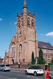
Neolithic implements have been discovered at Cheetham Hill, implying human habitation 7–10,000 years ago. The Roman Catholic church of St Chad was opened in 1847. The Anglican churches as of 1955 were St Mark’s (1794), St Luke’s (1839), St John Evangelist’s (Paley & Austin, 1871), St Alban’s (J. S. Crowther) and St Chad’s.
Cheetham, Manchester geography / climate
Cheetham is 1.4 miles (2.3 km) northeast of Manchester city centre. To the north, it is bordered by Crumpsall, to the west by Broughton in Salford, and to the east and the southeast by Harpurhey and Collyhurst.
Why visit Cheetham, Manchester with Walkfo Travel Guide App?
 You can visit Cheetham, Manchester places with Walkfo Cheetham, Manchester to hear history at Cheetham, Manchester’s places whilst walking around using the free digital tour app. Walkfo Cheetham, Manchester has 364 places to visit in our interactive Cheetham, Manchester map, with amazing history, culture & travel facts you can explore the same way you would at a museum or art gallery with information audio headset. With Walkfo, you can travel by foot, bike or bus throughout Cheetham, Manchester, being in the moment, without digital distraction or limits to a specific walking route. Our historic audio walks, National Trust interactive audio experiences, digital tour guides for English Heritage locations are available at Cheetham, Manchester places, with a AI tour guide to help you get the best from a visit to Cheetham, Manchester & the surrounding areas.
“Curated content for millions of locations across the UK, with 364 audio facts unique to Cheetham, Manchester places in an interactive Cheetham, Manchester map you can explore.”
Walkfo: Visit Cheetham, Manchester Places Map
364 tourist, history, culture & geography spots
Cheetham, Manchester historic spots | Cheetham, Manchester tourist destinations | Cheetham, Manchester plaques | Cheetham, Manchester geographic features |
| Walkfo Cheetham, Manchester tourism map key: places to see & visit like National Trust sites, Blue Plaques, English Heritage locations & top tourist destinations in Cheetham, Manchester | |||
Best Cheetham, Manchester places to visit
Cheetham, Manchester has places to explore by foot, bike or bus. Below are a selection of the varied Cheetham, Manchester’s destinations you can visit with additional content available at the Walkfo Cheetham, Manchester’s information audio spots:

Blackley Cemetery
Blackley Cemetery is a large, municipal cemetery situated within the northern suburbs of Manchester . It is owned, operated and maintained by Manchester City Council . It was opened in 1953 on land that was previously a golf course .
Ardwick
Ardwick is a district of Manchester in North West England, one mile south east of the city centre . The population of the Ardwick Ward at the 2011 census was 19,250 . Historically in Lancashire, by the mid-nineteenth century Ardwick had grown from being a village into a wealthy suburb of Manchester . By the end of that century it had become heavily industrialised .

O2 Apollo Manchester
The O2 Apollo Manchester is a concert venue in Ardwick Green, Manchester . It is a Grade II listed building with a capacity of 3,500 (2,514 standing, 986 seats)

National Graphene Institute
The National Graphene Institute is a research institute and building at the University of Manchester . It is focused on the research of graphene . Construction of the building started in 2013 and finished in 2015 .

The Star and Garter
The Star and Garter has a room upstairs for club nights and gigs . It is situated on Fairfield Street behind Piccadilly railway station . It has been Grade II listed building since 20 June 1988 .

B of the Bang
B of the Bang was a sculpture by Thomas Heatherwick next to the City of Manchester Stadium in Manchester, England . It was one of the tallest structures in Manchester and the tallest sculpture in the UK until the completion of Aspire in 2008 . The sculpture took its name from a quotation of British sprinter Linford Christie, in which he said that he started his races not merely at the “bang” of the starting pistol, but at “the B of The Bang”

Chips, Manchester
Chips is a nine-storey apartment building in New Islington, Manchester . It is part of an urban renewal project, New islington Millenium Village, led by Urban Splash . It was designed by Will Alsop, founder of the architect who designed Chips . In January 2018 Chips failed a Greater Manchester Fire and Rescue Service risk assessment .

The Warehouse Project
Warehouse Project is a series of club nights organised in Greater Manchester . Unlike most other clubs, it has a limited seasonal approach rather than running all year . Each year’s season runs from September through to New Years Day, plus occasional one off dates such as Bank Holiday weekends .

Piccadilly Tower
Piccadilly Tower (Eastgate or Inacity Tower) is a proposed development designed by Woods Bagot in Manchester city centre, England .

Gateway House, Manchester
Gateway House replaced a row of 19th-century railway warehouses on the approach to Manchester Piccadilly station . Richard Seifert & Partners designed the modernist office block in 1969 .
Visit Cheetham, Manchester plaques
 147
147
plaques
here Cheetham, Manchester has 147 physical plaques in tourist plaque schemes for you to explore via Walkfo Cheetham, Manchester plaques audio map when visiting. Plaques like National Heritage’s “Blue Plaques” provide visual geo-markers to highlight points-of-interest at the places where they happened – and Walkfo’s AI has researched additional, deeper content when you visit Cheetham, Manchester using the app. Experience the history of a location when Walkfo local tourist guide app triggers audio close to each Cheetham, Manchester plaque. Explore Plaques & History has a complete list of Hartlepool’s plaques & Hartlepool history plaque map.


 Trying to encourage visitors to Cheetham, Manchester?