Welcome to Visit Cefn Rhigos Places The Walkfo guide to things to do & explore in Cefn Rhigos
Visit Cefn Rhigos places using Walkfo for free guided tours of the best Cefn Rhigos places to visit. A unique way to experience Cefn Rhigos’s places, Walkfo allows you to explore Cefn Rhigos as you would a museum or art gallery with audio guides.
Visiting Cefn Rhigos Walkfo Preview Cefn Rhigos is a hamlet (place) to the west of the village of Rhigo, Wales. Despite being eight (8) miles from the town centre, for postal purposes it comes under Aberdare. It is the most westerly named settlement of the Cynon Valley. When you visit Cefn Rhigos, Walkfo brings Cefn Rhigos places to life as you travel by foot, bike, bus or car with a mobile phone & headphones.
Visit Cefn Rhigos – Walkfo’s stats for the places to visit
With 22 audio plaques & Cefn Rhigos places for you to explore in the Cefn Rhigos area, Walkfo is the world’s largest heritage & history digital plaque provider. The AI continually learns & refines facts about the best Cefn Rhigos places to visit from travel & tourism authorities (like Wikipedia), converting history into an interactive audio experience.
Why visit Cefn Rhigos with Walkfo Travel Guide App?
You can visit Cefn Rhigos places with Walkfo Cefn Rhigos to hear history at Cefn Rhigos’s places whilst walking around using the free digital tour app. Walkfo Cefn Rhigos has 22 places to visit in our interactive Cefn Rhigos map, with amazing history, culture & travel facts you can explore the same way you would at a museum or art gallery with information audio headset. With Walkfo, you can travel by foot, bike or bus throughout Cefn Rhigos, being in the moment, without digital distraction or limits to a specific walking route. Our historic audio walks, National Trust interactive audio experiences, digital tour guides for English Heritage locations are available at Cefn Rhigos places, with a AI tour guide to help you get the best from a visit to Cefn Rhigos & the surrounding areas.
“Curated content for millions of locations across the UK, with 22 audio facts unique to Cefn Rhigos places in an interactive Cefn Rhigos map you can explore.”
Walkfo Cefn Rhigos tourism map key: places to see & visit like National Trust sites, Blue Plaques, English Heritage locations & top tourist destinations in Cefn Rhigos
Best Cefn Rhigos places to visit
Cefn Rhigos has places to explore by foot, bike or bus. Below are a selection of the varied Cefn Rhigos’s destinations you can visit with additional content available at the Walkfo Cefn Rhigos’s information audio spots:
Moel Penderyn Moel Penderyn is in the Brecon Beacons National Park in the county borough of Rhondda Cynon Taff, south Wales. Its summit at 371m is marked by a trig point.
River Mellte River Mellte is formed by the confluence of Afon Llia and the Afon Dringarth. It flows south through the village of Ystradfellte to Pontneddfechan where it joins the River Neath. The river derives its name from ‘mellt’ – the Welsh word for ‘lightning’
Rhigos Rhigos is a small village on the saddle of higher ground between the Vale of Neath and the Cynon Valley. It was part of the old Neath Rural district Council under Glamorgan until 1974. The population of the community in the 2011 census was noted as 894. For postal purposes it comes under the town of Aberdare.
Tower Colliery Tower Colliery (Welsh: Glofa’r Tŵr) was the oldest continuously working deep-coal mine in the UK. It was located near the villages of Hirwaun and Rhigos, north of Aberdare in the Cynon Valley of South Wales.
Dinas Rock Dinas Rock (Welsh: Craig y Ddinas, “Fortress Rock”) is a high promontory of Carboniferous Limestone. It rises between Afon Mellte and its left-bank tributary, the Afon Sychryd. It derives its name from the presence of Iron Age earthworks on its summit.
Foel Chwern Foel Chwern is a Bronze Age burial monument dating to the Bronze Age. It is sited on the edge of a steep scarp slope, with a wide field of view to the north. The long distance footpath Coed Morgannwg Way runs close by the cairn.
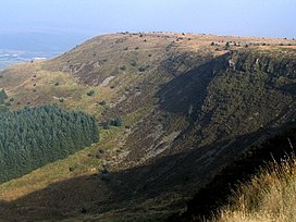
Craig y Llyn Craig y Llyn (Welsh, ‘rock/cliff of the lake’) is a mountain situated to the south of the village of Rhigos in the Cynon Valley. It is the highest point in the traditional county of Glamorgan (Morgannwg) and the South Wales Valleys.
Llyn Fawr Llyn Fawr is one of a series glacial cirques that form the northern escarpment of the South Wales Coalfield uplands. It is known as the site of an important hoard of weapons and tools from the late Bronze Age and early Iron Age. It lies on the northern flanks of Craig-y-Llyn, a mountain designated as a Site of Special Scientific Interest.
Visit Cefn Rhigos plaques
0 plaques hereCefn Rhigos has 0 physical plaques in tourist plaque schemes for you to explore via Walkfo Cefn Rhigos plaques audio map when visiting. Plaques like National Heritage’s “Blue Plaques” provide visual geo-markers to highlight points-of-interest at the places where they happened – and Walkfo’s AI has researched additional, deeper content when you visit Cefn Rhigos using the app. Experience the history of a location when Walkfo local tourist guide app triggers audio close to each Cefn Rhigos plaque. Currently No Physical Plaques.
Experience Cefn Rhigos audio walks & tours
Walkfo guides for things to do / places to visit in Cefn Rhigos allows exploration as you would do an art gallery or museum. Walk close to one of Cefn Rhigos’s 22 historic places & our digital tour guide will create an audio story for that spot. With headphone connected, you can explore Cefn Rhigos freely by foot, bike or bus – with your own personal tour guide in your pocket.
Explore Cefn Rhigos Map App
Our visit Cefn Rhigos map shows you things-to-do & places you can visit in Cefn Rhigos & surrounding areas using the Walkfo digital audio tour guide app. Each spot has plaque, building, street or area information on history, culture or tourism.
You can set your Walkfo’s Cefn Rhigos tourist map to find historic & tourism spots within 1km, 3km & 5km of the Cefn Rhigos centre, depending on how far you plan to explore whilst you visit Cefn Rhigos area at LONG:-3.5728, LAT:51.7508.
Walkfo App
Walkfo
Walkfo is free to download & use (for a limited time period), so if you are looking to explore Cefn Rhigos, go to your App Store to search for “Walkfo” or follow a links below and install on your mobile phone. Walkfo is designed for use with headphones or AirPods, so you can walk & explore whilst learning about the things around you without digital distraction.
Things to do & visit in Cefn Rhigos / surrounding areas
● Glynneath (electoral ward) ● Glynneath ● Penderyn distillery ● Penderyn, Rhondda Cynon Taf ● Moel Penderyn ● Waterfall Country (Wales) ● Pontneddfechan ● Afon Pyrddin ● River Mellte ● Rhigos ● Cwm-Hwnt ● Cefn Rhigos ● Tower Colliery ● Dinas Rock ● Afon Sychryd ● Foel Chwern ● Dyffrynnoedd Nedd a Mellte, a Moel Penderyn ● Craig y Llyn ● Nedd Fechan ● Llyn Fawr ● Caeau Nant y Llechau ● Afon Hepste
Getting to / around Cefn Rhigos – transport link, station & street map
Getting around in Cefn Rhigos using public transportation may include road, street, train, underground, bus or tram transport options. Walkfo has identified the following Cefn Rhigos places with historic / cultural / factual content when you visit:
Local Cefn Rhigos Public Transport Stations
Cefn Rhigos Notable Streets & Road Destinations
British Rhondda Halt railway station
[transportsummary]
Local Cefn Rhigos historians & Cefn Rhigos tour guides
Trying to encourage visitors to Cefn Rhigos? Walkfo has millions audio places already available but Walkfo Creator gives Cefn Rhigos’s places, attractions & landmarks ability to create their own unique outdoor audio museums & using our simple & easy to use Walkfo Creator. – Creating a new audio experience for your Cefn Rhigos place is free* and quick (15+ minutes if you prepare text content) to use, with Walkfo Creator doing the hard work of generating AI audio files for geo-spots from the text you provide with a simply click on a map. – The 100 Amazing Cefn Rhigos Places is just one example of an outdoor museum created using Walkfo Creator (pictured to the left) for people to safely explore during Covid-19 times whilst visiting a city. Our tool is open to tourism organisations, travel destinations & National Trust locations to create their own audio walks to offer free when people visit Cefn Rhigos destinations. – Walkfo itself is looking to partner with websites offering things-to-do / what’s on events listings to enhance the content of our ‘visit-Cefn Rhigos’ web pages (for example: www.visitCefn Rhigos.com). If you are interested in partnering, please contact us to discuss options.
* Walkfo Creator is free to use for a limited number of audio spots within a map with a license fee applicable when more than 20 audio spots within location walk are created. v1.1336
 Visit Cefn Rhigos places using Walkfo for free guided tours of the best Cefn Rhigos places to visit. A unique way to experience Cefn Rhigos’s places, Walkfo allows you to explore Cefn Rhigos as you would a museum or art gallery with audio guides.
 You can visit Cefn Rhigos places with Walkfo Cefn Rhigos to hear history at Cefn Rhigos’s places whilst walking around using the free digital tour app. Walkfo Cefn Rhigos has 22 places to visit in our interactive Cefn Rhigos map, with amazing history, culture & travel facts you can explore the same way you would at a museum or art gallery with information audio headset. With Walkfo, you can travel by foot, bike or bus throughout Cefn Rhigos, being in the moment, without digital distraction or limits to a specific walking route. Our historic audio walks, National Trust interactive audio experiences, digital tour guides for English Heritage locations are available at Cefn Rhigos places, with a AI tour guide to help you get the best from a visit to Cefn Rhigos & the surrounding areas.


 0
0


 Trying to encourage visitors to Cefn Rhigos?